*Stratospheric warming to result in additional cold air outbreaks Great Lakes-to-Northeast US...baseball season gets fully underway on Thursday (3/27) with plenty of cold weather early season games*
Paul Dorian

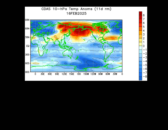
This 30-day loop of stratospheric temperatures features significant warming (shown in orange) in recent weeks at the high latitudes of the northern hemisphere (polar region at top). This on-going stratospheric warming event will likely have an impact well into the month of April with additional cold air outbreaks from Canada into the northeastern quadrant of the nation. Maps courtesy NOAA
Overview
An on-going stratospheric warming event that began in late February increases the chance for additional cold air outbreaks as we wind down the month of March from the Great Lakes/Midwest to the Mid-Atlantic/Northeast US. In fact, the typical lag time between a stratospheric warming event over the polar region and its impact on US temperature patterns suggests there may very well be cold air outbreaks to deal with in this part of the country at least until the middle of April. As it turns out, big-league baseball gets underway in earnest in one week’s time on Thursday, March 27th, and the early part of the season may feature plenty of cold weather games thanks in large part to the on-going big-league stratospheric warming event. In addition, the influx of colder-than-normal air masses in coming weeks keeps hope alive across the northern states for those wishing for more snow...yes, even though spring season is now officially underway.

The recent spike in temperatures (shown in red) at the stratospheric level of 10 millibars exceeds any such warming events that took place earlier this winter season and any that took place last winter (timeline begins in January of 2024 at left). Map courtesy NOAA
Details
While there were a couple of regular season games played this week in Tokyo, Japan (roofed stadium) between the Cubs and Dodgers, the main start to the 2025 big-league season comes next Thursday, March 27th with 14 games on the schedule. At least half of the games are to be played in southern states from Florida-to-Arizona where the weather is likely to be quite favorable for baseball or are scheduled for the “relatively-safe” southern California cities of Los Angeles and San Diego. There are a handful of games, however, that are scheduled for next Thursday in the Midwest (Chicago, Cincinnati) and Mid-Atlantic/Northeast US (New York City, Washington, D.C.) where cold weather is always a possibility this time of year and appears to be quite likely in a week’s time. In fact, the first few weeks of the 2025 baseball season are likely to feature plenty of cold weather games; especially, in the region from the Great Lakes/Midwest to Mid-Atlantic/NE US thanks in large part to an on-going stratospheric warming event the likes of which in the past have often been followed by several weeks of cold air outbreaks into the US.

The stratospheric temperature pattern as of Thursday, March 20th, features a relatively “warm” blob of air directly over the North Pole (center) and a weakened and “split” polar vortex (shown in blue). Temperatures at the 10-millibar level over the North Pole are now about 40 degrees warmer than those observed in the surrounding stratospheric polar vortex regions. Map courtesy NOAA
Stratospheric warming is a naturally occurring phenomenon that can take place in any given winter in the northern hemisphere and perhaps even on more than one occasion. Typically, temperatures are very cold in the stratosphere over the polar region during the northern hemisphere winter, but periodically, significant warming takes place which can disrupt the polar vortex. In some cases, the polar vortex is displaced from its usual location near or over the pole, but it remains fully intact. In other cases, however, the polar vortex can break apart into multiple pieces and is considerably weakened...indeed, this is the pattern we are experiencing right now in the northern hemisphere polar region.

There have been six stratospheric warming events in recent history that took place during the month of March and the average 10-millibar temperature pattern in those years (left plot) is very similar to the current situation. The impact on US temperatures in each of those six years during the subsequent month of April was quite dramatic. In fact, the average temperature in those six years for the month April was below-normal across virtually the entire nation (right plot). Maps courtesy Weather Bell Analytics (Meteorologist Joe Bastardi, X), NOAA
When the polar vortex is disrupted during the northern hemispheric winter, it can set off a chain of events in the atmosphere that ultimately results in cold air masses being unleashed from the high latitudes onto the middle latitudes such as here in the US. History has shown that there tends to be a lag of several weeks from the beginning of the stratospheric warming event over the polar region to its eventual impact on US temperatures. In this particular case, the stratospheric warming event that began during late February increases the chance for colder-than-normal weather through the end of March across the northeastern quadrant of the country from the Great Lakes/Midwest to the Mid-Atlantic/NE US. In fact, there may be winter weather conditions right in the middle of April for this part of the nation which could make for many chilly baseball games during the early part of the 2025 baseball season in places like Chicago, Detroit, Cleveland, Boston, New York and Philadelphia.

The 2025 big-league baseball season gets fully underway in one week’s time on Thursday, March 27th and it may be quite a bit colder -than-normal across the Great Lakes, Midwest and Northeast US (shown in blue, purple). In fact, the early part of this year’s baseball season may feature plenty of cold weather games; especially, across the Great Lakes, Midwest and Northeast US…largely as a result on the on-going stratospheric warming event. Map courtesy ECMWF, tropicaltidbits.com
In recent history, there have been six stratospheric warming events that took place during the month of March and each one of these years (1975, 1982, 1984, 1993, 2007, 2018) featured a colder-than-normal month of April across a huge part of the nation.

Given the expected onslaught of additional cold air outbreaks from Canada into the US, the chance for snow will remain quite high across many parts of the northern US; especially, in higher elevation locations. This 00Z Euro forecast map of “total snowfall” during the next ten days suggests spring skiing will be quite doable in the higher elevations of the northeastern part of the nation. Map courtesy ECMWF, Pivotal Weather
In terms of snow, the influx of colder-than-normal air masses during late March and April certainly raises hope for snow lovers across the northern states that there can be some early spring accumulating snow. In fact, there are likely to be multiple chances for snow in coming weeks across the northern states; especially, in higher elevation locations...a very nice pattern for late season skiing in, for example, the interior Northeast US.

The early part of the 1982 baseball season was marred by plenty of cold and snow and the stretch of winter-like weather that April followed a stratospheric warming event in March that was pretty similar to the one we are currently experiencing over the polar region. The home openers for the Mets and Yankees were postponed several days due to a snowstorm on the 6th that generated a foot of snow in the New York City metro region. Newspaper article courtesy New York Times (top) and snow scene at Yankee Stadium (bottom) courtesy WABC (NYC, Channel 7).
While certainly not common, it is not unprecedented that early spring accumulating snow falls in the big cities along the I-95 corridor of the Mid-Atlantic/Northeast US. In fact, a snowstorm in April of 1982 disrupted the early part of that baseball season and caused postponements of both the Mets and Yankees home openers when a foot of snow fell on New York City. Other home openers that year had to be postponed as well including those in Chicago and Milwaukee. The unusually cold stretch of weather in April of 1982 indeed followed a significant stratospheric warming event that took place during the month of March...quite similar circumstances to what we are experiencing this year.
Meteorologist Paul Dorian
Arcfield
arcfieldweather.com
Follow us on Facebook, Twitter, YouTube
Video discussion: