
Thursday AM, June 19th - ****Severe weather threat later today/early tonight...an extended stretch of high heat and humidity****
Paul Dorian
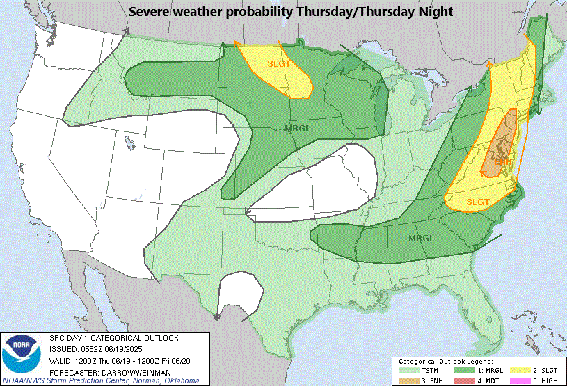
NOAA’s Storm prediction Center (SPC) places the Mid-Atlantic’s I-95 corridor in an “enhanced” risk of severe weather later today/early tonight. Map courtesy NOAA
Overview
Many ingredients are coming together to raise the chance of severe weather later this afternoon and evening in the Mid-Atlantic region. A strong surface cold front, high heat and humidity, and an impressive upper-level disturbance will help to destabilize the atmosphere this afternoon and there are likely to be strong-to-severe thunderstorms impacting the I-95 corridor somewhere between 2pm and 8pm. The cold front clears the coast by late tonight and Friday will turn out to be a less humid day featuring plenty of sunshine and warm conditions.
The moderate humidity expected on Friday will give way to an extended stretch of high heat and humidity in the Mid-Atlantic region from later this weekend into at least the middle of next week. A very strong ridge of high pressure will build into the eastern states, and this will lead to high temperatures well up in the 90’s for multiple days all along the DC-to-Philly-to-NYC corridor.

One of the ingredients today that will lead to an enhanced risk of severe weather in the Mid-Atlantic region is an impressive “short-wave” dropping southeastward across the Great Lakes. Map courtesy NOAA, tropicaltidbits.com
Severe weather threat later this afternoon into early tonight
A warm front pushed northward through the Mid-Atlantic region on Wednesday and opened the door for high heat and humidity which will be a contributing factor to the destabilization of the atmosphere. In addition, other ingredients that will enhance upward motion in the area and raise the risk of severe weather will include a strong surface cold front, and a vigorous “short-wave” in the upper part of the atmosphere. Temperatures in the I-95 corridor will warm quickly during the next few hours through the 80’s to near 90 degrees, and the very moist environment will likely feature the breakout of showers and thunderstorms across the western Mid-Atlantic region by late morning/mid-day (West Virginia, western PA). These showers and thunderstorms will likely then increase in coverage and intensity and push east-to-northeast towards the DC-to-Philly-to-NYC corridor with 2pm-8pm a likely timetable for the possibility of strong-to-severe thunderstorm activity in the big city regions.

There will be an enhanced threat of severe weather on Thursday afternoon and evening in the DC-to-Philly-to-NYC corridor as a strong surface cold front approaches from the northwest. Any strong-to-severe thunderstorm can produce downpours, vivid lightning, and damaging wind gusts...hail and isolated tornadoes on the table as well. Map courtesy NOAA, tropicaltidbits.com
The main risk later today/early tonight with any strong-to-severe thunderstorm will be damaging wind gusts that can reach 60+ mph and there will be downpours that can produce localized flash flooding conditions in already well-saturated areas. In addition, vivid lightning is on the table and large hail and isolated tornadoes cannot be ruled out. The cold front clears the coast by late tonight and - though it won’t be much cooler on Friday - it should be noticeably less humid compared to today.

Very strong upper-level ridging will form in the eastern states by early next week leading to a surge of high heat and humidity in the DC-to-NYC corridor. This coming heat wave will result in temperatures climbing well up in the 90’s in the I-95 corridor during the first half of next week and 100 degrees can be reached in some spots. Map courtesy ECMWF, Pivotal Weather
Extended stretch of high heat and humidity
While today will feature some high heat and humidity in the Mid-Atlantic region, it will be rather short-lived as the late-night frontal passage should usher in noticeably less humid air for the end of the work week. By later this weekend, however, an extended stretch of high heat and humidity will begin in the DC-to-Philly-to-NYC corridor as a very strong ridge of high pressure pushes into the eastern states and becomes a slow-mover.

A surge of heat (orange, red) reaches the eastern states during the early and middle parts of next week as strong upper-level ridging of high pressure develops overhead. Meanwhile, cooler-than-normal conditions (blue) dominate the western states as an upper-level low develops in that area. Map courtesy ECMWF, Pivotal Weather
The sweltering heat will first be felt early this weekend across the central Plains, Mississippi Valley and Great Lakes (e.g., Chicago in the middle 90’s for highs on Saturday), and then the high heat and humidity reaches the eastern states on Sunday (e.g., DC in the middle 90’s for highs on Sunday). That very strong ridge of high pressure aloft will likely remain located over the eastern states into at least the middle of next week translating to perhaps a 4- or 5-day period of high heat and humidity all along the DC-to-Philly-to-NYC corridor with daily highs well up in the 90’s...and perhaps 100 degrees will be reached in some spots.

This forecast map by the high-resolution version of the Euro model features high temperatures near 100 degrees for several days next week in Philly, PA. While this may certainly be overdone, it raises a red flag that an extended period of high heat is coming to the Mid-Atlantic region. Histogram plot courtesy ECMWF, weathermodels.com
Meteorologist Paul Dorian
Arcfield
arcfieldweather.com
Follow us on Facebook, Twitter, YouTube
Video discussion: