
***An onslaught of cold across the eastern half of the nation in coming days...even Florida is impacted (“falling iguana” alert)...late month extreme cold on the table...snow threats as well***
Paul Dorian
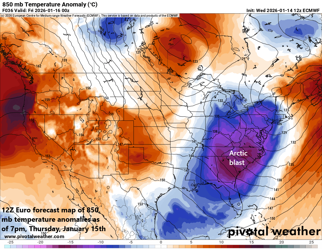
An Arctic blast pushes into the Mid-Atlantic region and Northeast later tonight on the heels of a strong cold frontal system and this won’t be the last…additional Arctic blasts are destined tor each the eastern states during the next couple of weeks. This near-term Arctic blast will be accompanied by accumulating snow in many parts of the interior Mid-Atlantic and Northeast US with at least half a foot on the table. Map courtesy ECMWF, Pivotal Weather
Overview
The next couple of weeks are likely to feature multiple Arctic air outbreaks across the eastern half of the nation and even the state of Florida will be impacted (watch out iguanas). This kind of evolving pattern that features a major disruption of the polar vortex can certainly include some extreme cold during what is statistically speaking the coldest time of the year later in the month. This cold weather pattern will be quite active as well with multiple snow threats along the way for the Great Lakes, Midwest, Mid-Atlantic and Northeast US...and perhaps some snow this weekend in unusual places like the Southeast US.
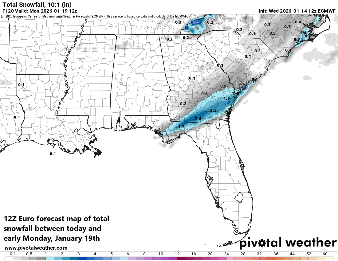
Not only will this near-term Arctic blast affect areas in the Southeast US, but it may also set the stage for some snow this weekend in some unusual places as a strong upper-level disturbance slides to the south and east from Canada. Map courtesy ECMWF, Pivotal Weather
Details
A strong cold front will barrel through the northeastern states later tonight and its passage will not go unnoticed. In fact, temperatures are likely to drop rather sharply behind the front in the late-night hours from the mild levels of today to mid-winter levels on Thursday. Temperatures on Thursday may be reluctant to rise much at all along the DC-to-Philly-to-NYC corridor holding around the freezing mark in the big cities and a stiff NW wind will make it feel even colder than the actual outdoor temperatures. On Thursday night, the Arctic blast will really make its presence felt with overnight lows in the teens in many suburban locations along the I-95 corridor. Indeed, this Arctic blast is likely to have an impact all the way down to Florida where Friday morning lows should be below freezing in cities like Orlando and Lakeland...iguanas need to be on alert. [On occasion, the weather in Florida can get cold enough for iguanas to become “cold-stunned”, making them fall from trees because their bodies slow down and they lose their grip; they aren't dead but can seem lifeless, so don't touch them, as they can bite and will revive as temperatures rise, but watch where you walk and keep pets clear].
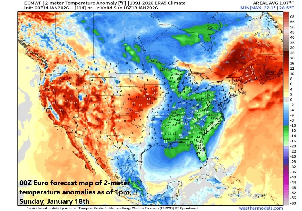
A second blast of Arctic air will arrive in the eastern later this weekend and it also can impact places way down in the southeastern part of the US. Map courtesy ECMWF, weathermodels.com
The sharp drop in temperatures following the frontal passage in the overnight hours along the DC-to-Philly-to-NYC corridor could result in some slick spots on the roadways which should be wet following the rain that falls this afternoon and evening. In addition, there can be a brief transition to snow late tonight as colder air rushes in just before the precipitation winds down. This incoming cold frontal system will act as a catalyst for low pressure to form along its boundary zone early tonight in central Pennsylvania and this low will help to produce accumulating snow as it moves north in places like northwestern PA, western and northern New York (6+ inches on the table).
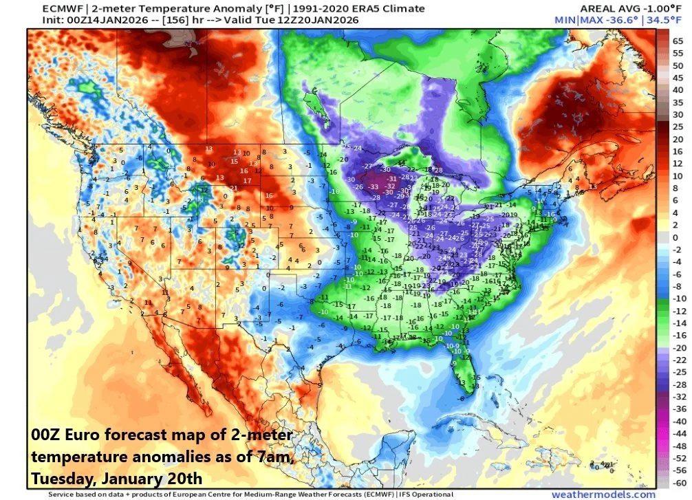
Yet another Arctic blast is destined to arrives in the eastern states by next Tuesday/Wednesday and this one can feature temperatures as much as 25 or 30 degrees below-normal. Map courtesy ECMWF, weathermodels.com
Over the weekend, another Arctic blast will reach the north-central US, and it’ll head south and east across the Great Lakes and towards the Mid-Atlantic/Northeast US. This Arctic blast will be accompanied by a strong short-wave of energy in the upper atmosphere dropping south and east from Canada and rotating through a long-wave trough. The exact path this upper-level disturbance takes this weekend will dictate where and how much snow may fall and it is not out of the question that some of the white stuff falls way down in portions of the Southeast US....stay tuned on the weekend situation as many details have to be ironed out.
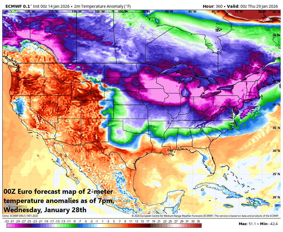
Still a couple weeks away and yet, the signals for some extreme cold late this month have been very persistent. This forecast map of 2-meter temperature anomalies by the 00Z Euro features some extreme cold during the last week of January…a time of year that is statistically the coldest time of year. Map courtesy ECMWF, Weather Bell Analytics
On the heels of the weekend system, yet another Arctic air mass will flood the eastern states early next week with well below-normal temperatures – as much as 25 or 30 degrees below – during a period that is statistically speaking, the coldest time of the year. Looking ahead, there are rather persistent signs that additional Arctic blasts will take place during the last week of January, and a predicted disruption of the stratospheric polar vortex supports the idea that this late month’s invasion could feature some extremely cold air. The overall pattern will stay active as well late in January with additional snow threats quite likely on the table.
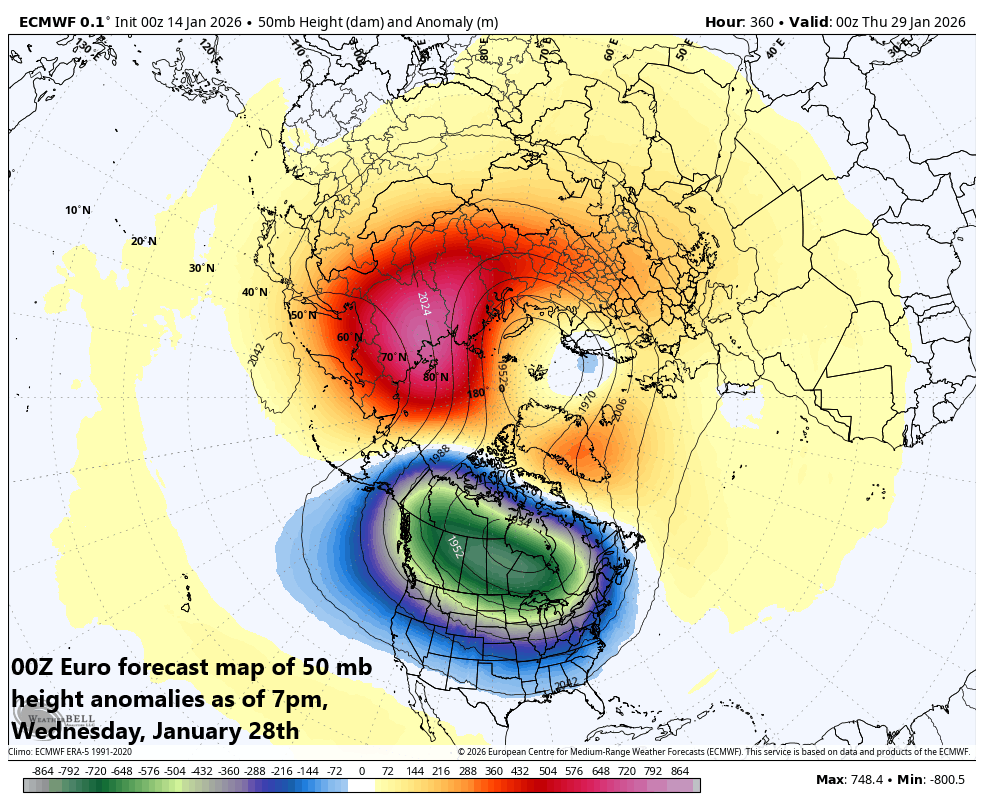
A contributing factor to a very cold weather pattern late in the eastern half of the nation later this month is going to be a major disruption of the stratospheric polar vortex. This forecast map of 50 mb height anomalies features the displacement of the stratospheric polar vortex to the Canadian side of the North Pole. Map courtesy ECMWF, Weather Bell Analytics
Meteorologist Paul Dorian
Arcfield
arcfieldweather.com
Follow us on Facebook, Twitter, YouTube
Video discussion: