
***Arctic air spreads all the way to Florida...another Arctic blast arrives this weekend...another early next week...extreme cold possible later this month...weekend snow threats***
Paul Dorian
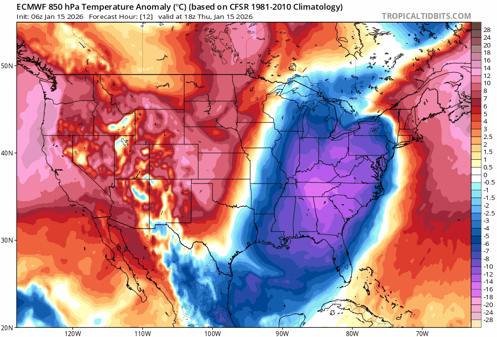
One Arctic air mass pushed into the eastern states on Thursday…the next one arrives later in the upcoming weekend…and a third blast comes during the early-to-middle part of next week. Looking ahead, additional Arctic blasts are likely as we work through the last week of January (not shown) and that time period may feature some extreme cold. Maps courtesy ECMWF, tropicaltidbits.com
Overview
An Arctic air mass has reached the eastern US today on the heels of a strong cold frontal system and this winter chill will extend all the way down to the state of Florida by later tonight. Another Arctic air mass will push into the north-central US early this weekend and it’ll spread to the east coast later in the weekend. The frontal boundary zone at the leading edge of the weekend Arctic blast will act as a catalyst for waves of low pressure to form and one system can bring some snow to parts of the eastern US from later Friday night to Saturday and a second on Sunday. The second low pressure system can bring snow to unusual places in the southeastern part of the nation on Sunday, and its snow field may extend far enough to the north and west to have an impact in the DC-to-Philly-to-NYC corridor. Following the passage of the Sunday system, yet another Arctic air mass will drop south and east into the northern US on Sunday night, and it’ll put the Mid-Atlantic region and Northeast US into the deep freeze by time Monday night and Tuesday roll around. Looking ahead, numerous signs point to additional Arctic air outbreaks as we work through the last week of January and this time period could feature some extreme cold.
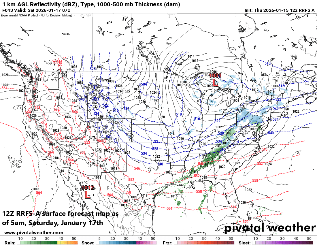
Low pressure may develop early this weekend along an incoming cold frontal system and it could generate some snow for the Mid-Atlantic region from late Friday night into Saturday morning. By later Saturday, any precipitation that falls in the I-95 corridor could be of the mixed variety as temperatures (briefly) modify. Map courtesy NOAA, Pivotal Weather
Details
A strong cold front barreled through the eastern states early Thursday and temperatures have been generally stuck in place along the DC-to-Philly-to-NYC corridor. In addition, winds have stiffened from a northwesterly direction making it feel even colder than the actual outdoor temperatures. Temperatures late Thursday night could bottom out in the teens across some suburban locations in the I-95 corridor and they’ll remain well below normal on Friday as clouds tend to increase.
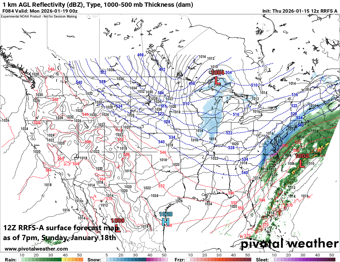
Low pressure is likely to push to the northeast on Sunday near the eastern seaboard and it could bring snow to unusual places like the Southeast US and perhaps as far north and west as the Mid-Atlantic’s I-95 corridor region. Map courtesy NOAA, Pivotal Weather
The increase in clouds on Friday will come ahead of an incoming upper-level disturbance and on the front side of the next Arctic cold frontal system. This Arctic frontal boundary zone will be the catalyst for waves of low pressure to form during the upcoming weekend, one of which can bring some snow to the Mid-Atlantic region from later Friday into Saturday morning and small accumulations are possible. As temperatures modify on Saturday afternoon ahead of the next incoming front, any precipitation that falls could become mixed with sleet and/or rain; especially, in the big cities along the I-95 corridor.
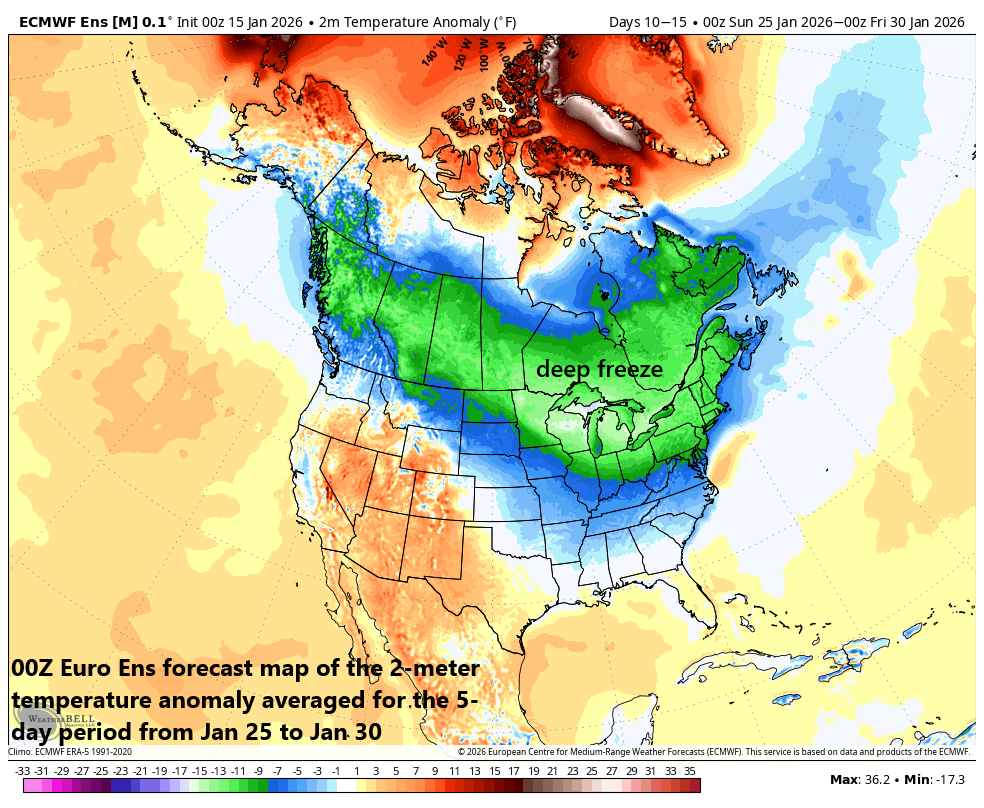
Arctic outbreaks are likely to continue right into the last week of the month as indicated here by this forecast map of 2-meter temperature anomalies for the 5-day period from 25 Jan to 30 Jan. Map courtesy ECMWF, Weather Bell Analytics
On Sunday, the Arctic cold front will continue its trek to the south and east and a second low pressure system is likely to form along its boundary zone. This low is likely to ride up along the east coast at the same time cold air advances to the south and east and the result can be some snow in unusual places across the southeastern states (e.g., eastern Carolinas, eastern Georgia). As this system pushes to the northeast on Sunday, it is possible that some accumulating snow extends far enough to the north and west of the low pressure center to have an impact in the I-95 corridor from DC-to-Philly-to-NYC…stay tuned.
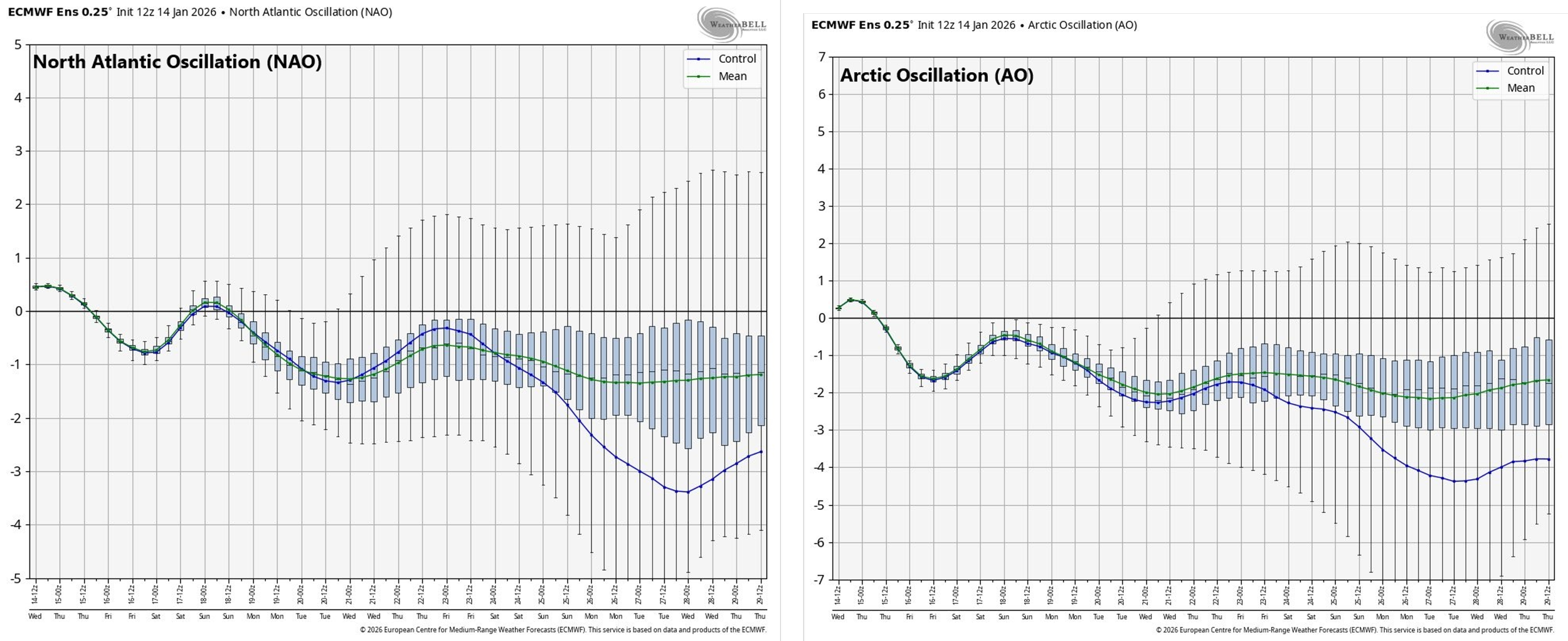
The North Atlantic Oscillation (NAO, left plot) and Arctic Oscillation (AO, right plot) remain in “negative” territory through the second half of January which is generally correlated with colder-than-normal conditions across the central and eastern US. Plots courtesy NOAA, Weather Bell Analytics
Following the passage of the Sunday system, yet another Arctic air mass will plunge into the north-central states on Sunday night, and it will most assuredly spread to the south and east during the early part of next week. Consequently, the Mid-Atlantic region will likely be in the deep freeze by the time Monday night, Tuesday, and Tuesday night roll around, and this incoming bitter cold air mass could result single digit low temperatures in some of suburban locations along the I-95 corridor. Looking ahead, there are signs from computer forecast models and predicted trends in teleconnection indices that additional Arctic air outbreaks are likely during the last week of the month for the central and eastern US and the potential exists for some extreme cold to mix into the picture...bottom line, not looking forward to the next electric bill.
Meteorologist Paul Dorian
Arcfield
arcfieldweather.com
Follow us on Facebook, Twitter, YouTube
Video discussion: