
*****Major winter storm to impact a large part of the nation this weekend...significant snowfall in the Mid-Atlantic and some icing possible...bitter cold air sets the stage...bitter cold follows*****
Paul Dorian
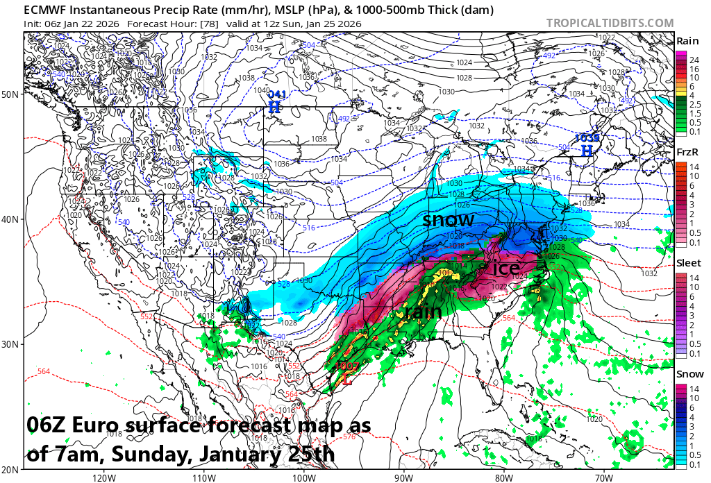
Snow could be falling heavily at 7 AM on Sunday morning in the DC-to-Philly-to-NYC corridor with very cold conditions…wild weather indeed. There can be icing across central Virginia at the same time as a thin layer of slightly above freezing air advances slowly to the north. An initial low pressure system will head to KY/WV and then a secondary low will develop just off the Mid-Atlantic coastline and it’ll become the main player by later Sunday. Map courtesy ECMWF, tropicaltidbits.com
Overview
Buckle up…the next ten days or so will be quite wild. The latest in a series of Arctic air outbreaks is plunging today into the north-central states today and it’ll swallow up much of the eastern two-thirds of the nation by the upcoming weekend. This Arctic outbreak means business and features some extremely cold air with temperatures well below zero in many spots, and it’ll set the stage for widespread impacts this weekend by a major storm system. A crippling ice event is on the table for many in the Texas-to-Virginia corridor, and a significant snowfall in other areas including the DC-to-Philly-to-NYC corridor where some icing may get involved. Following the storm, brutally cold conditions are likely to continue across much of the nation including in the Mid-Atlantic region where morning lows during the first half of next week may reach seldom seen territory.
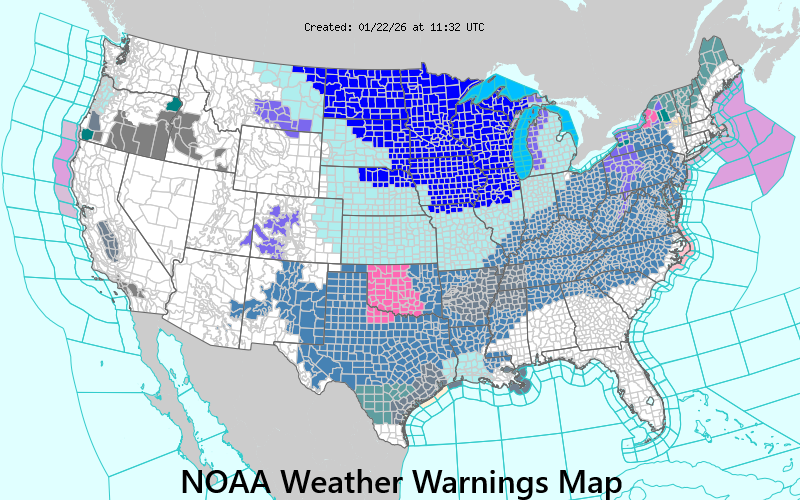
The map is already filled with Winter Storm Watches/Warnings (blue, pink) and Extreme Cold Warnings (dark blue) as issued by NOAA for the upcoming winter weather event. Map courtesy NOAA
Details
It turns noticeably milder today in the Mid-Atlantic region with temperatures likely to reach the 50-degree mark in some spots along the I-95 corridor such as in Washington, D.C. However, a look at the unfolding temperature pattern upstream raises a red flag that this warmup will be just a temporary blip. Indeed, the latest in a series of Arctic air outbreaks is now invading the north-central states and it’ll swallow up much of the eastern two-thirds of the nation by the upcoming weekend setting the stage for significant and widespread impacts by a major winter storm. This incoming Arctic blast means business with temperatures likely to drop to as low as 30 degrees below zero across parts of the Northern Plains and wind chills there can reach 50 below.
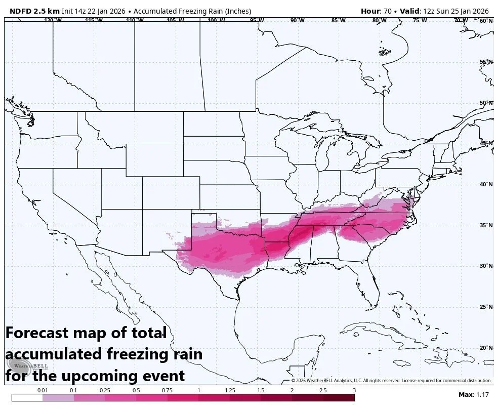
There can be significant icing during this weekend storm primarily in the region from Texas-to-Virginia and, unfortunately, this can lead to numerous power outages in some of those locations. Map courtesy NOAA
On Friday, copious amounts of moisture will start gathering across the south-central states. As this moisture shield then heads to the north and east, it will encounter this very cold air mass and frozen precipitation will break out with significant icing likely this weekend across many southern states all the way from Texas-to-Virginia.
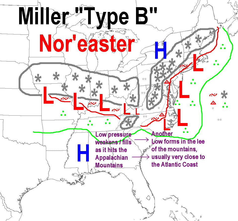
There are a few different types of storm tracks that tend to dominate during a winter season in the central and eastern US. One storm track which dominated during the first half of the winter was along a line from southwestern Canada to the NE US. These “clipper” low pressure system pushed along in the polar jet which dominated the early winter. A “Miller A” storm track is one that takes low pressure right up over or near the eastern seaboard. A third storm track known as a “Miller B” features an initial or primary low that heads to the Appalachians, weakens, and transfers its energy to a newly forming secondary low just off the east coast. This “Miller B” scenario is what we will be dealing with this weekend in the northeastern part of the country.
As the moisture pushes farther to the north and east, snow will break out, and significant accumulations are on the table all the way from the southern Plains to the Mid-Atlantic/Northeast US. One difficulty in the forecast with respect to total snow accumulations for the immediate DC-to-Philly-to-NYC corridor is that sleet can mix into the picture - perhaps even some freezing rain - despite surface temperatures likely staying below freezing throughout the event and icing would keep a cap on final amounts. Some slight warming can take place aloft as the initial (primary) surface low heads towards Kentucky/West Virginia before it weakens and transfers its energy to a secondary low pressure that’ll form just off the Mid-Atlantic coastline (a “Miller B” type of storm track). As the initial low reaches its most northward extent over the Appalachians, so will the slight warming in the upper atmosphere, and then as the secondary low becomes the main player just off the east coast, colder air aloft will tend to push back to the south and east...some areas may see sleet change back to snow before the precipitation winds down.
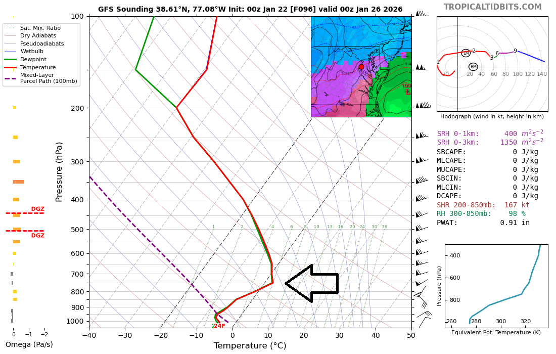
While surface temperatures will remain below-freezing throughout this event, there can be a thin layer of air aloft with slightly above-freezing temperatures and this can cause sleet to fall; especially, across the southern Mid-Atlantic. This vertical profile data is for later Sunday just to the south of Washington, D.C. and the arrow indicates the narrow layer with slightly above-freezing air. Map courtesy NOAA, tropicaltidbits.com
Despite the threat of some icing, this should turn out to be one of the biggest snowstorms in many years for the DC-to-Philly-to-NYC corridor with preliminary estimates of at least 8-14 inches in most areas. The timeframe in the Mid-Atlantic’s I-95 corridor appears to be from Saturday night into early Monday morning meaning there can be impacts on travel conditions to start the new work week. The heaviest snow in the DC, Philly, NYC corridor may fall on Sunday morning and there will be very cold conditions at this time…some wild weather indeed for at least a few hours.
Brutally cold air sets the stage for the major winter storm this weekend and bitter cold air will follow with low temperatures in seldom seen territory next week in the Mid-Atlantic region including the big cities of DC, Philly and NYC. Map courtesy ECMWF, tropicaltyidbits.com
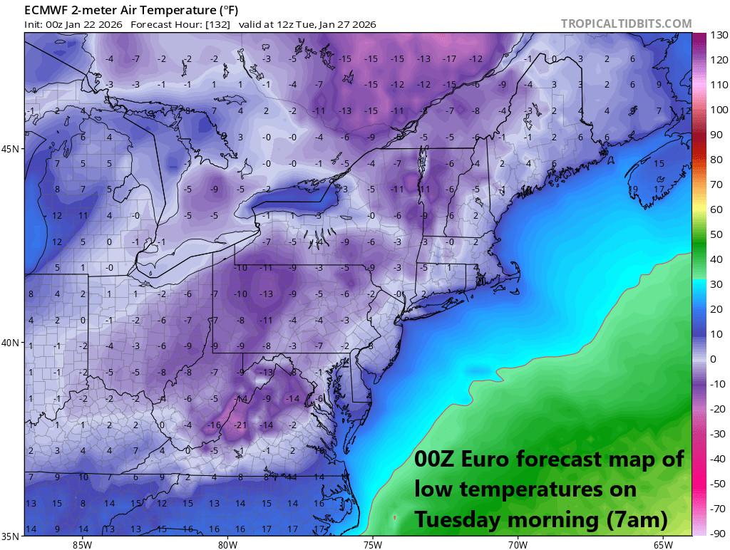
Bitter cold air will follow the storm with some rarely-seen low temperatures possible in the Mid-Atlantic region during the first half of next week. The last time Philly and Washington, D.C. recorded temperatures below zero was in January of 1994…Central Park (NYC) last went below zero in February of 2016. And a quick look ahead, there can be another major storm to deal with along the east coast in about a week after this upcoming event (i.e., somewhere around 1/31-2/1)...more on that threat next week.
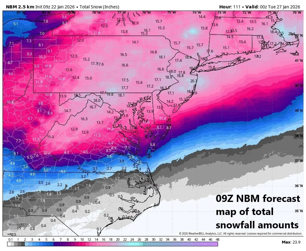
This is a forecast map of total snowfall for the upcoming event by a compilation of computer forecast models with significant amounts throughout the Mid-Atlantic region. Any sleet and freezing rain that falls would put a limit on final snowfall amounts. Map courtesy NOAA, Weather Bell
There are still a few days to go before this weekend’s event and there will likely be some adjustments; however, from this vantage point, all signs continue to point to a major winter storm that will have big-time impacts across a large portion of the nation…this would include a crippling ice event in some areas, and a significant snowfall in other areas including the DC-to-Philly-to-NYC corridor where some icing may get involved…buckle up.
Meteorologist Paul Dorian
Arcfield
arcfieldweather.com
Follow us on Facebook, Twitter, YouTube
Video discussion: