
**A mild weather pattern in the Mid-Atlantic region to peak on Friday and Saturday and there will be plenty of rainfall...cold front reverses the milder trend by Sunday/Monday**
Paul Dorian
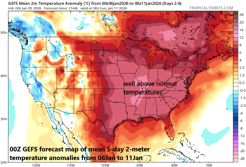
A warmer weather pattern is finally coming to the northeastern states for the period from the mid-week to the early part of the weekend. A strong cold front will pass through the eastern states late Saturday bringing an end to the warm-up and moderately cold conditions are likely to return for Sunday. Map courtesy NOAA, tropicaltidbits.com
Overview
It has been persistently cold in the northeastern states from around Thanksgiving Day to the present time with the month of December being observed as the coldest since 2010 in many spots including Washington, D.C. and New York City. A warmer weather pattern is on the way, however, which will bring noticeably milder conditions to the region in the Wednesday through Saturday time period. The peak in temperatures will come on Friday and Saturday for the northeastern states, but both of those will feature some rainfall dampening the mood a bit. The next strong cold front looks like it’ll arrive in the eastern states late on Saturday, and its passage will reverse the warmer trend by the time we get to the second half of the upcoming weekend and the early part of next week.
Details
The overall weather pattern across the northeastern states has been colder-than-normal since around Thanksgiving Day and the month of December turned out to be the coldest since 2010 in many spots including Washington, D.C. (DCA) and New York City (Central Park). The first few days of January have been much the same in the Mid-Atlantic region with well below normal temperatures since the new year got underway last Thursday...changes are, however, on the way.
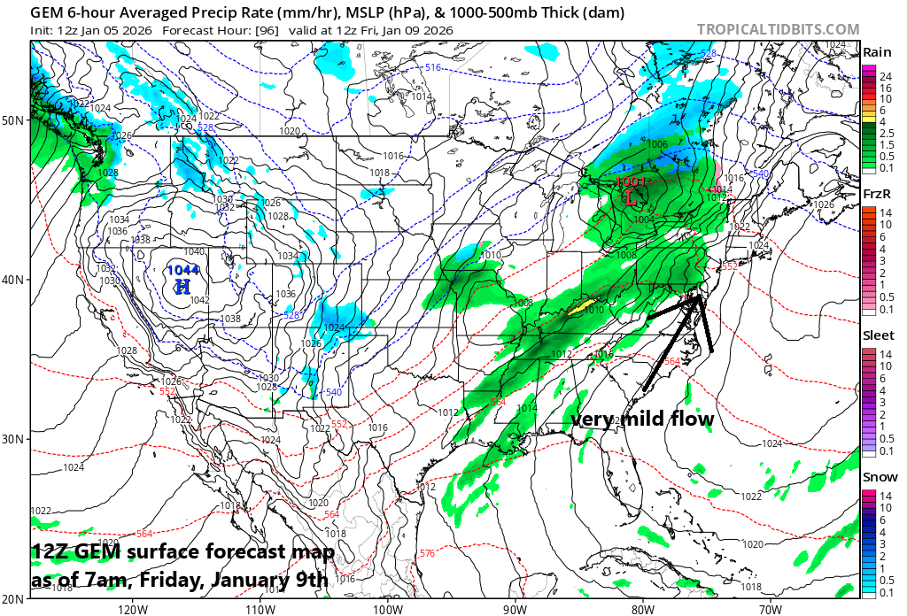
The warmest days of the week in the eastern US are likely to come on Friday and Saturday - ahead of the next strong cold front - with temperatures boosted by stiff south-to-southwest winds and there will likely be some rainfall on both of those days. Map courtesy Canadian Met Centre, tropicaltidbits.com
It looks like a noticeably milder pattern will take place across the northeastern states for about a 4- or 5-day period from this mid-week through the first half of the upcoming weekend. The new work week has started off on the chilly side in the Mid-Atlantic region with temperatures on Monday below normal; however, some improvement comes on Tuesday in the temperature department, and it turns even milder at mid0-week. An upper-level ridge of high pressure will develop over the eastern states by the middle of the week, and this will lead to the overspreading of milder air from the middle of the country with temperatures here climbing into above-normal territory. There will be a weak cold front passing through the Mid-Atlantic region late in the day on Wednesday and this could knock off a few degrees for Thursday, but above-normal temperatures should still generally prevail.
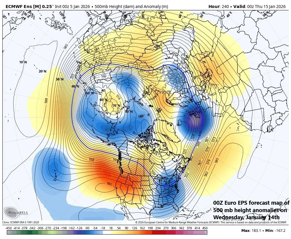
By later next week, a trough of low pressure is likely to form in the eastern US (shown in blue) and higher heights than normal (shown in orange) could extend all the from western Canada to the western Atlantic. If this pattern indeed develops, it would raise the chances for wintry weather conditions to return to the northeastern part of the country. Map courtesy ECMWF, Weather Bell
By later this week, the overall weather pattern gets more active bringing the threat of showers to the eastern states on Friday and the threat of rain will continue on Saturday as well. In fact, the late week active weather pattern could even result in some heavy rainfall and strong thunderstorms across the Mississippi and Tennessee Valleys. A deepening low-pressure system over the central part of the nation will push a warm front through the northeastern states by the end of the work week and stiffening south-to-southwest winds will boost temperatures to their warmest levels of the week on Friday and Saturday. In fact, temperatures on Friday and Saturday should surpass the 60-degree mark in the DC metro region and likely reach well up into the 50’s in the Philly and NYC metro regions - despite plenty of clouds and frequent showers. The strong low-pressure system will lift north into the Great Lakes region on Saturday and drag its trailing strong cold front through the eastern states by Saturday night paving the way for (moderately) colder temperatures during the latter half of the upcoming weekend and the early part of next week.
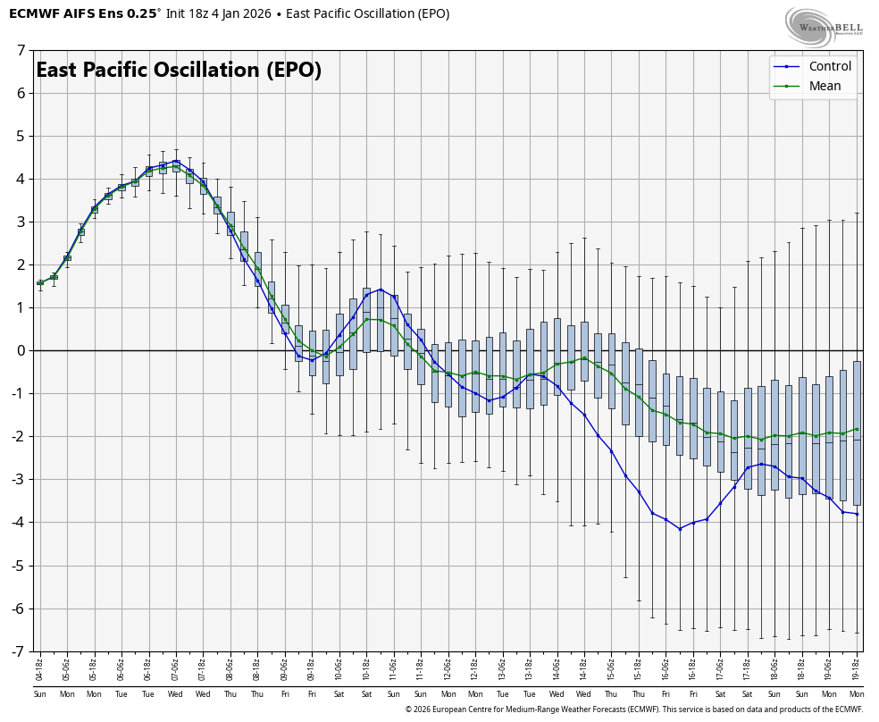
One of the teleconnection indices that supports the idea of a return to colder-than-normal weather next week across the northeastern states is the East Pacific Oscillation (EPO) which drops back into “negative” territory after a spike to “positive” territory. A sustained period of “negative” levels for the EPO this time of year generally favors colder-than-normal weather across the central and eastern US. Plot courtesy NOAA
Looking ahead, there are signs that a trough of low pressure will develop over the eastern states during the early and middle parts of next week at the same time higher heights develop in the region extending all the way from western Canada to the western Atlantic. It is too early to say if this kind of upper-level pattern will indeed come to fruition, but this is something to monitor over the next several days as it would likely lead to wintry weather conditions once again across the northeastern quadrant of the country.
Meteorologist Paul Dorian
Arcfield
arcfieldweather.com
Video discussion: