**Not one, not two, but three very interesting tropical systems to monitor in coming days...two in the eastern Pacific and one in the Gulf**
Paul Dorian
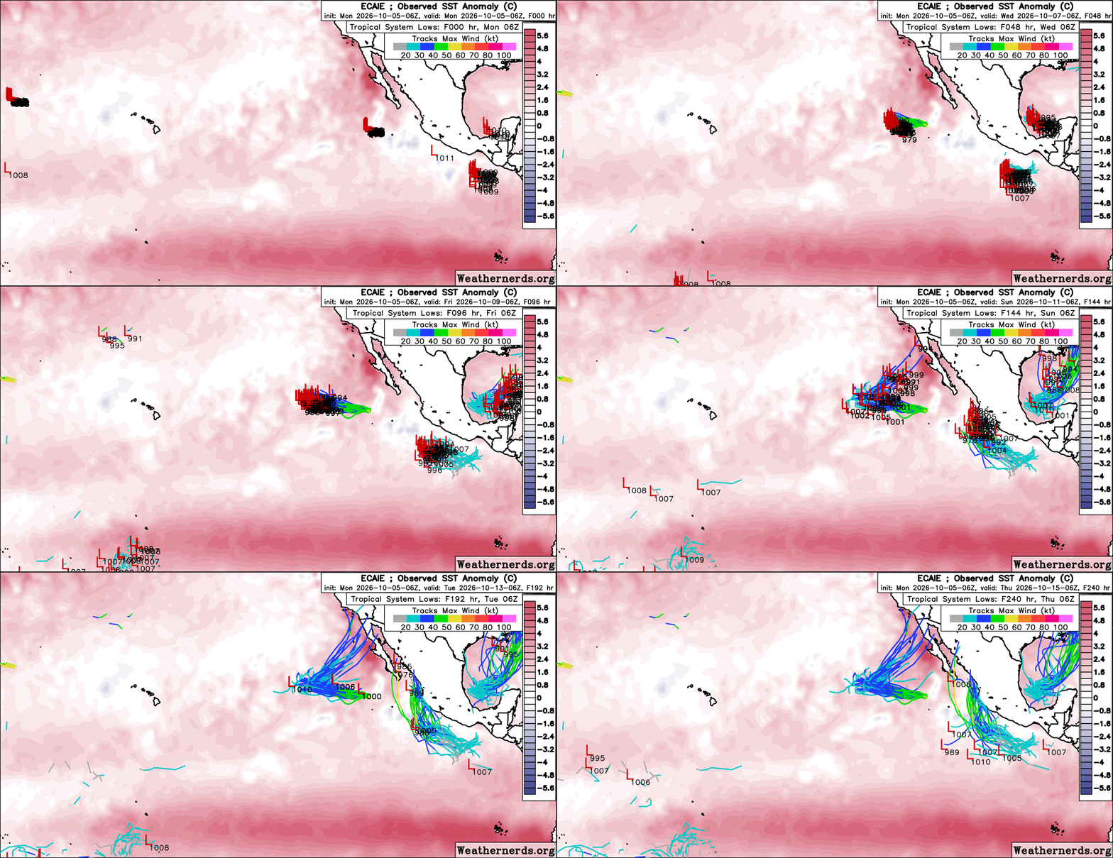
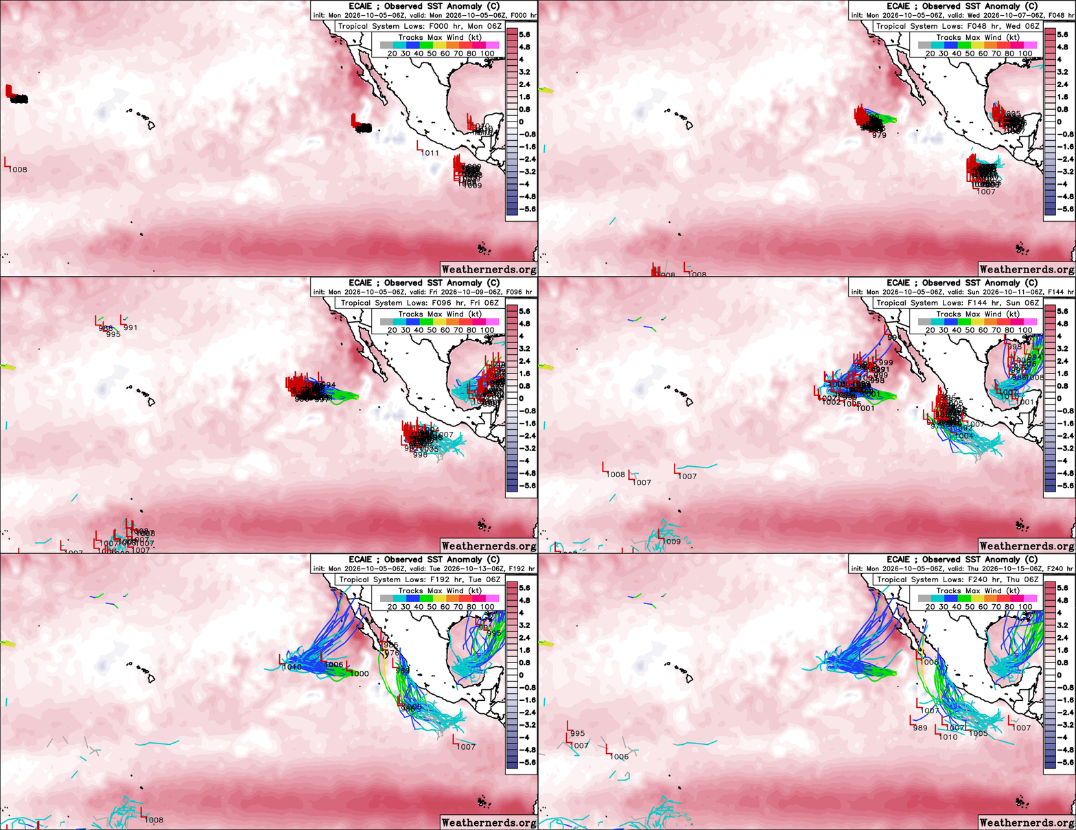
There are three tropical systems to monitor closely in coming days…two in the eastern Pacific Ocean including Hurricane Rachel which may experience a drastic change in direction by the weekend, and the third over very warm waters of the southwestern Gulf of America. There is a chance that this Gulf system becomes the 1st hurricane of the season in the Atlantic Basin. Maps courtesy ECMWF, weathernerds.org.
Overview
All in all, this looks like a relatively quiet and dry week for the continental US, but tropical systems may change that in a big way by this weekend or the early part of next week. There are not one, not two, but three tropical systems that will have to be closely monitored in coming days...two in the eastern Pacific and one in the Gulf. The only one of the three systems that is currently named is “Rachel” which is a minimal hurricane in the eastern Pacific that is on a seemingly harmless westerly track during the next few days. After that, however, there are signs that “Rachel” will take a drastic turn from a westerly direction to northeasterly, and this could bring its moisture field into the southwestern US and potentially, well up to the north of there.
The second tropical wave in the eastern Pacific should strengthen in the near term to become a named tropical storm and potentially, it can attain classification as a hurricane. This trailing system is likely to turn into Mexico and ultimately, its moisture field can impact the southwestern or south-central states. Meanwhile, a tropical wave now over the very warm waters of the southwestern Gulf of America can intensify into named tropical storm status and potentially into the season’s first hurricane for the Atlantic Basin as it pushes towards the northern Gulf region by the weekend…and potentially, well to the north of there.
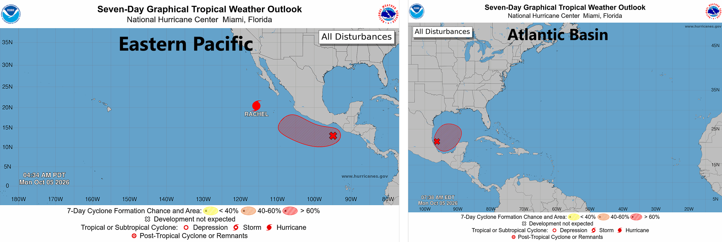
Hurricane Rachel is currently on a westward track, but this may change drastically to a northeasterly trajectory by the upcoming weekend. Two other tropical waves - one off the southern Mexico coastline and the other over the southwestern Gulf of America - are likely to intensify into named tropical storm status in coming days and potentially to hurricane levels. Maps courtesy NOAA/NHC
Details
Enjoy the quiet weather pattern across the continental US during the next four or five days or so as there are signs in the tropics that big changes may take place by the weekend or the early part of next week. Multiple high-pressure systems dominate the scene on Monday from coast-to-coast and most sections of the continental US are enjoying dry and quiet early October weather...but trouble is brewing to the south.
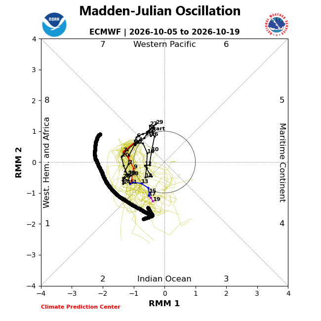
A teleconnection known as the Madden-Julian Oscillation or MJO will rotate into locations or “phases” that are usually correlated with increased tropical activity in the Atlantic Basin during this time of year. Plot courtesy NOAA, ECMWF
In the eastern Pacific Ocean, two tropical systems are alive and well. The front runner is Hurricane Rachel which has now been around for several days, and it is moving slowly (and seemingly harmlessly) to the west at around 7 mph with maximum sustained winds of 85 mph. There are signs, however, that “Rachel” may experience a pretty drastic change in direction by the end of the week from the current westerly trajectory to northeasterly which can push its moisture field towards the northern part of Baja California and ultimately, into the southwestern US. In fact, some long-range forecast maps (e.g., 00Z Euro) feature the remnants of “Rachel” pushing all the way into the northwestern US by early next week where enough cold air could cause its moisture to fall as snow in places like Montana and Idaho...certainly this forecast is in the “speculation phase”; nonetheless, quite an interesting possibility.
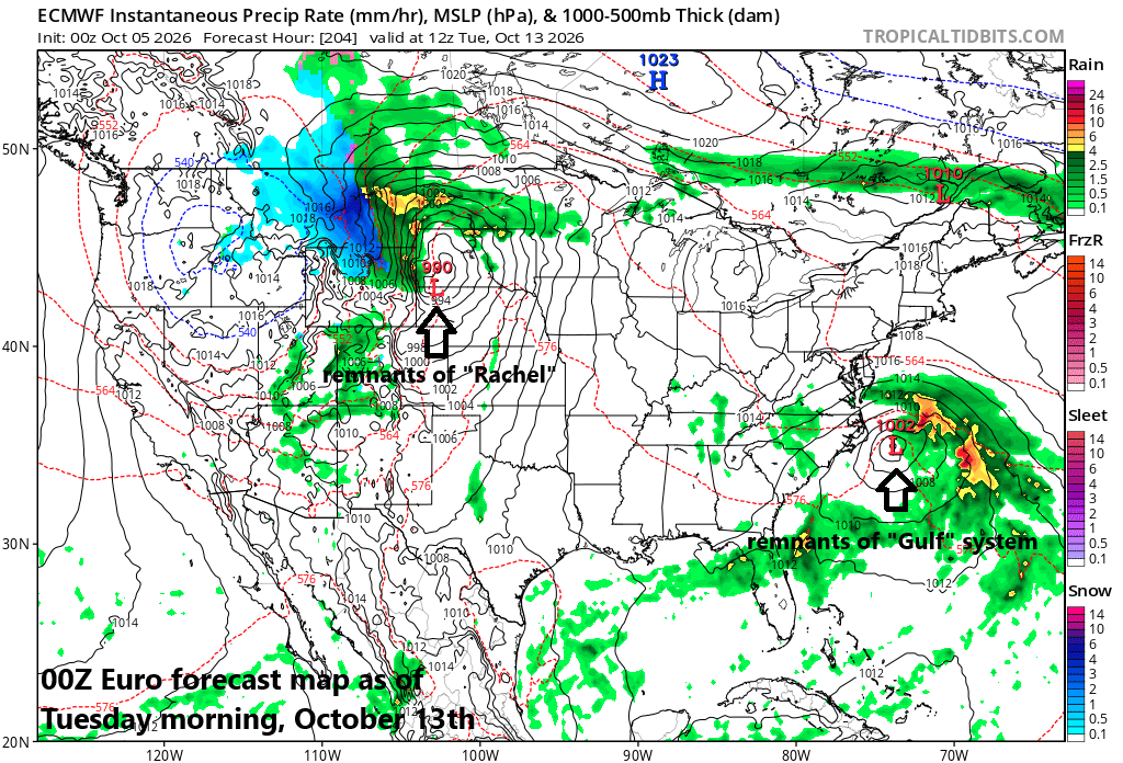
A longer-range forecast map by the 00Z Euro for next Tuesday, October 12th features the remnants of Hurricane Rachel all the way into the northern Rocky Mountain States and it could run into enough cold air up there for snow to fall in places like Montana and Idaho. Map courtesy ECMWF, tropicaltidbits.com
In addition to Rachel, there is a tropical system just off the southern Mexico coast and it has an excellent chance of intensifying into tropical storm status and potentially to hurricane levels as it treks over some very warm waters of the eastern Pacific (boosted in temperatures by the very strong El Nino). This trailing tropical system could turn northeastward into western Mexico and eventually its moisture field could have an impact on the south-central and/or southwestern US.
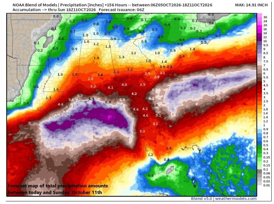
A tropical wave over the SW Gulf has a good chance of intensifying into tropical storm status and potentially even hurricane levels and it can produce copious amounts of rain for the northern Gulf region during the next several days. Map courtesy NOAA
Finally, there is a tropical wave now situated over the very warm waters of the southwestern Gulf and signs point to enough intensification in coming days for it to become a named tropical storm. Indeed, this system has the potential to become the first hurricane of this extremely quiet tropical season in the Atlantic Basin...already the latest in the season without a hurricane in more than one hundred years.
A teleconnection index that we follow this time of year is the Madden-Julian Oscillation or MJO and it pushes into territory that supports the idea of increased activity in the Atlantic Basin…even as the season winds down in the month of October. Moisture from the Gulf system could indeed push northward into the northern Gulf states by this weekend and potentially, farther north into the Tennessee Valley and perhaps even into the Mid-Atlantic region by the early part of next week...something to monitor in coming days.
Bottom line...while much of the continental US will enjoy a quiet and dry next four or five days, some trouble is brewing in the tropics.
Meteorologist Paul Dorian
Arcfield
arcfieldweather.com
Follow us on Facebook, Twitter, YouTube
Video discussion: