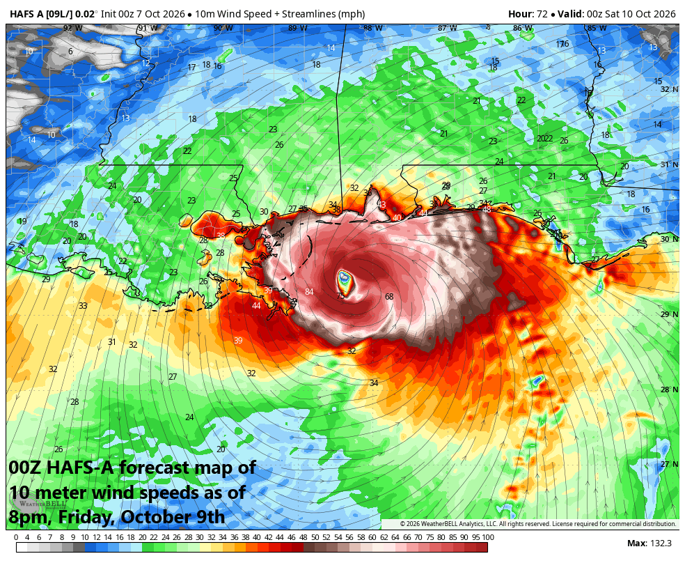
***“Isaias” to become first hurricane of the Atlantic Basin season...likely to slam the central Gulf coast on Friday night/early Saturday...impact to reach the Ohio Valley/Mid-Atlantic/NE US***
Paul Dorian
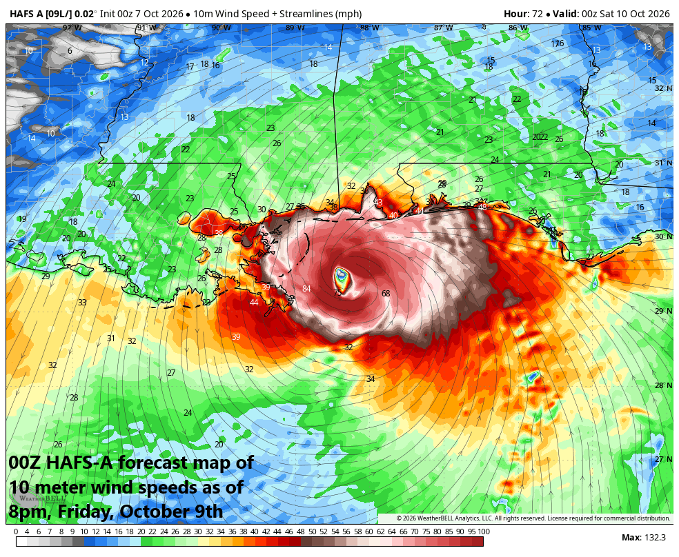
NOAA”S hurricane model known as the HAFS-A features the center of the hurricane just off the central Gulf coast on Friday evening with hurricane-force winds just offshore at this time. Map courtesy NOAA, Weather Bell Analytics (Meteorologist Joe Bastardi, X)
Overview
The tropics are alive and well and we now have a named tropical storm, Isaias, over the southwestern Gulf of America where water temperatures are near 30 degrees (C)...plenty capable of supporting a late season hurricane. TS Isaias is very likely to become the Atlantic Basin’s first hurricane of the season and can hit the central Gulf coast on Friday night or early Saturday...perhaps as a cat 2 hurricane. While landfall is likely to be in the region between southeast Louisiana and the western part of Florida’s Panhandle, all Gulf residents from Texas to Florida should closely monitor this system.
After landfall, the impact from Isaias is likely to continue well to the north of the northern Gulf with its rain shield possibly moving as far as the Ohio Valley, Mid-Atlantic and Northeast US by later in the weekend. Elsewhere on the tropical scene, Hurricane Rachel over the eastern Pacific is currently churning to the west-northwest; however, it will take a drastic turn to the northeast in coming days and head towards the northern Baja California region with impacts on the way for much of the western US including an added contribution to snow in the Northern Rocky Mountain States.
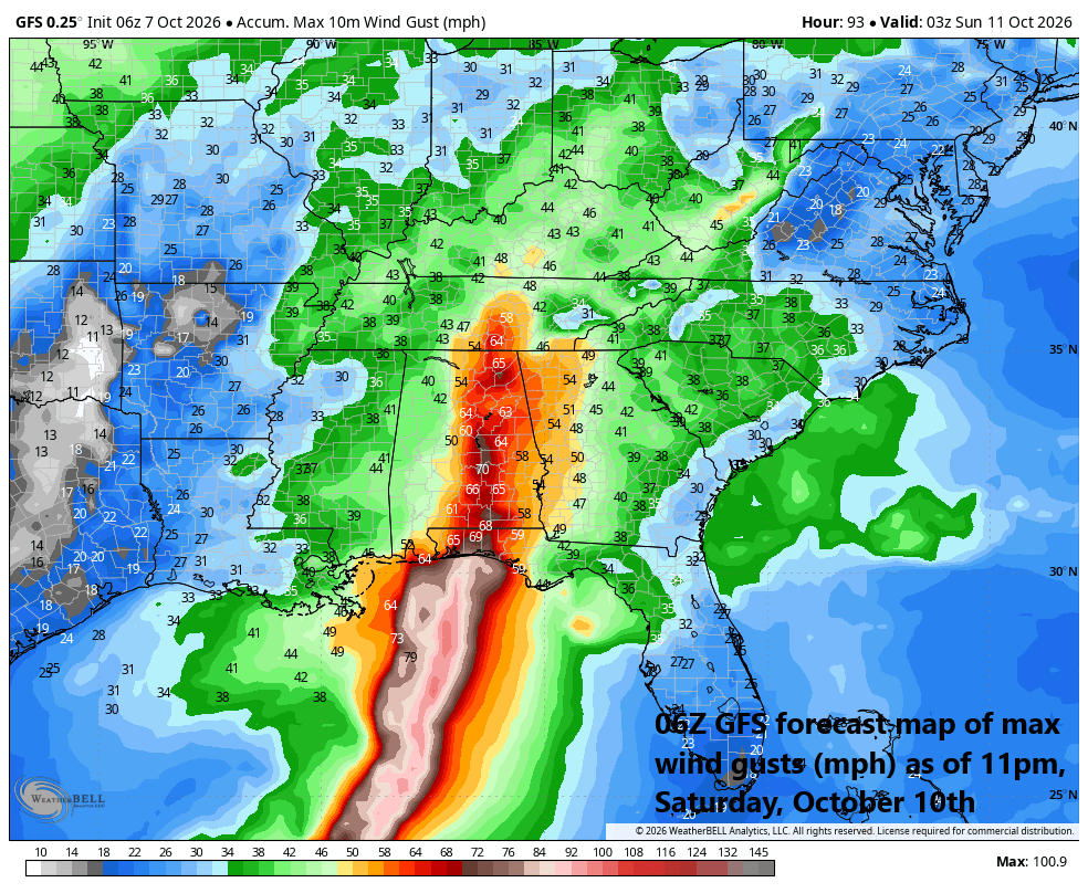
Wind gusts could remain quite powerful and still damaging all the way into the Tennessee Valley from the Gulf coast as environmental conditions will be quite supportive (jet streak, etc.). Map courtesy NOAA, Weather Bell Analytics (Meteorologist Joe Bastardi, X)
Details
There was hope that we could get through the entire Atlantic Basin tropical season without a hurricane, but our luck has run out here in early October and we now face the threat of a direct hit in the central Gulf by the end of the week. A tropical system over the very warm waters of the southwestern Gulf of America has reached classification as a named tropical storm, Isaias, and it is quite likely to reach hurricane status by the end of the week. In fact, favorable environmental conditions raise the risk of intensification into category 2 classification before a potential landfall in the central Gulf, and a “major” hurricane classification of category 3 cannot be completely ruled out.
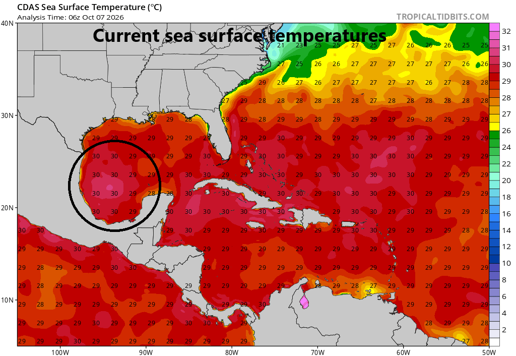
Current sea surface temperatures are near the 30 degrees Celsius mark which is plenty capable of supporting a hurricane despite the fact that we are now well into the month of October. Map courtesy NOAA
The favorable environmental conditions that support intensification of TS Isaias include very warm sea surface temperatures (30-31 degrees Celsius), plenty of moisture, and only light to moderate wind hear in the vicinity of its core center. Having said that, there are some signals that vertical wind shear can increase in the final hours before it reaches the central Gulf coast late Friday or early Saturday. Hopefully, this takes place which could cause some last-minute weakening, though it is looking pretty likely that it will be a significant hurricane when it reaches the coast. The most likely landfalling region is somewhere between the southeastern part of Louisiana and the western part of Florida’s Panhandle, but all Gulf coastal residents from Texas to Florida should monitor the still evolving situation.
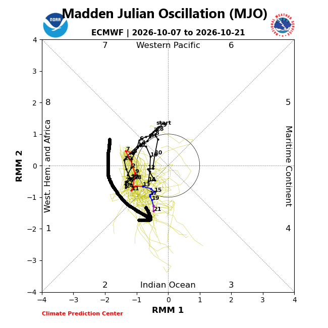
The teleconnection index known as the Madden -Julian Oscillation or MJO supports the notion of increased activity in the Atlantic Basin as it moves to locations or “phases” (e.g., 8, 1 and 2) that indicate increased upward motion in the Gulf of America and western Atlantic. Map courtesy NOAA, ECMWF
After landfall, the impact of Isaias is likely to last well to the north of the Gulf region during the upcoming weekend. The remnants of Isaias are likely to push north across the Deep South and Tennessee Valley and could end up over the Ohio Valley by later Saturday night or early Sunday. Typically, the right side of a northward moving tropical system after landfall can experience severe weather including the risk of tornadoes and this could place a risk across states such as Mississippi, Alabama, Georgia and Florida as the weekend gets underway. There indeed may be an impact on some college football games on Saturday; especially, in the Southeastern Conference.
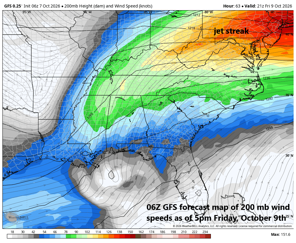
An upper-level jet streak will play a role in the weather across the eastern states on Friday night and Saturday by enhancing upward motion and raising the risk of severe weather in the southern states. Map courtesy NOAA, Weather Bell Analytics (Meteorologist Joe Bastardi, X)
Powerful and damaging wind gusts will accompany the storm system along the central Gulf coast, and these could survive all the way north into portions of Tennessee and Ohio Valleys as the remnants interact with an upper-level jet streak which will enhance upward motion well to the north of the Gulf coast. Ultimately, the rain shield of Isaias could push into the Mid-Atlantic region and Northeast US, and some heavy rain is certainly on the table in those areas from late Saturday night through Sunday.
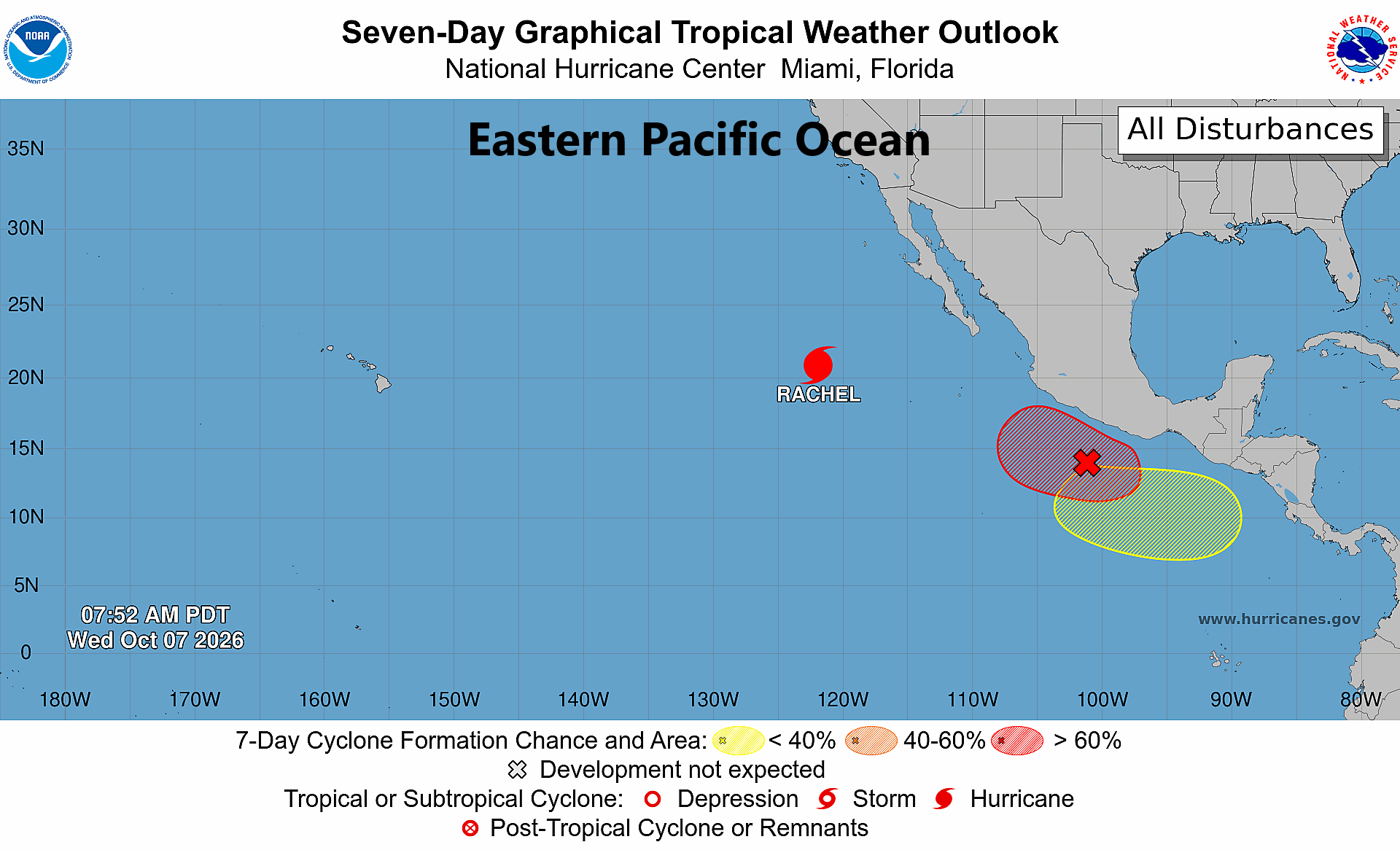
Hurricane Rachel continues to churn to the west-northwest over the eastern Pacific, but it will make a dramatic turn towards northern Baja by the weekend. Its moisture field will then cross southern California and impact much of the western US all the way north into the northern Rocky Mountain States where there will be enough cold air for accumulating snow. Map courtesy NOAA/NHC
In the eastern Pacific Ocean where tropical activity has been high this season, Hurricane Rachel continues to churn in a seemingly harmless west-to-northwest direction over some very warm waters that have been enhanced by a very strong El Nino. This tropical system is likely to take a dramatic turn by the end of the week from a west-northeast trajectory to northeast, likely bringing it near northern Baja California by late Saturday. After that, the moisture field associated with the remnants of Rachel will push across southern California and into the interior western US, perhaps all the way to the northern Rocky Mountains States. In fact, the tropical moisture field of Rachel – now centered way down south over the eastern Pacific Ocean - could very well end up enhancing snowfall in places like Montana, Idaho and Wyoming by the end of the weekend or early part of next week...quite an amazing turn of events.
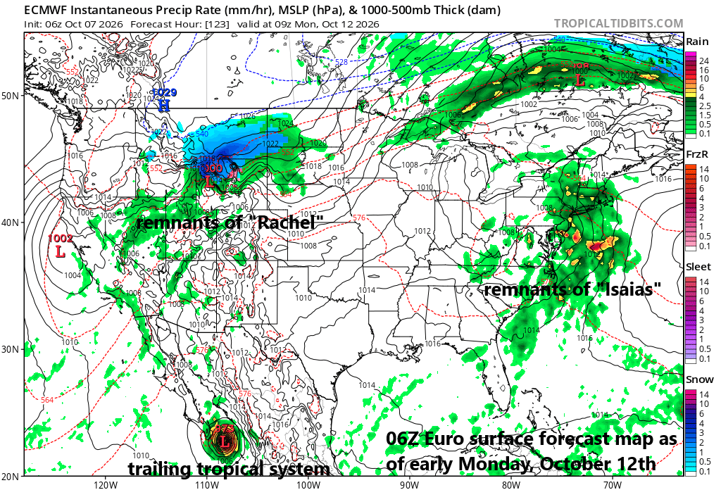
Meanwhile, a second tropical wave over the far eastern Pacific may very well develop into a hurricane in the near term and then veer into northwestern Mexico by the end of the weekend potentially bringing another batch of tropical moisture to the southwest and south-central US by early next week.
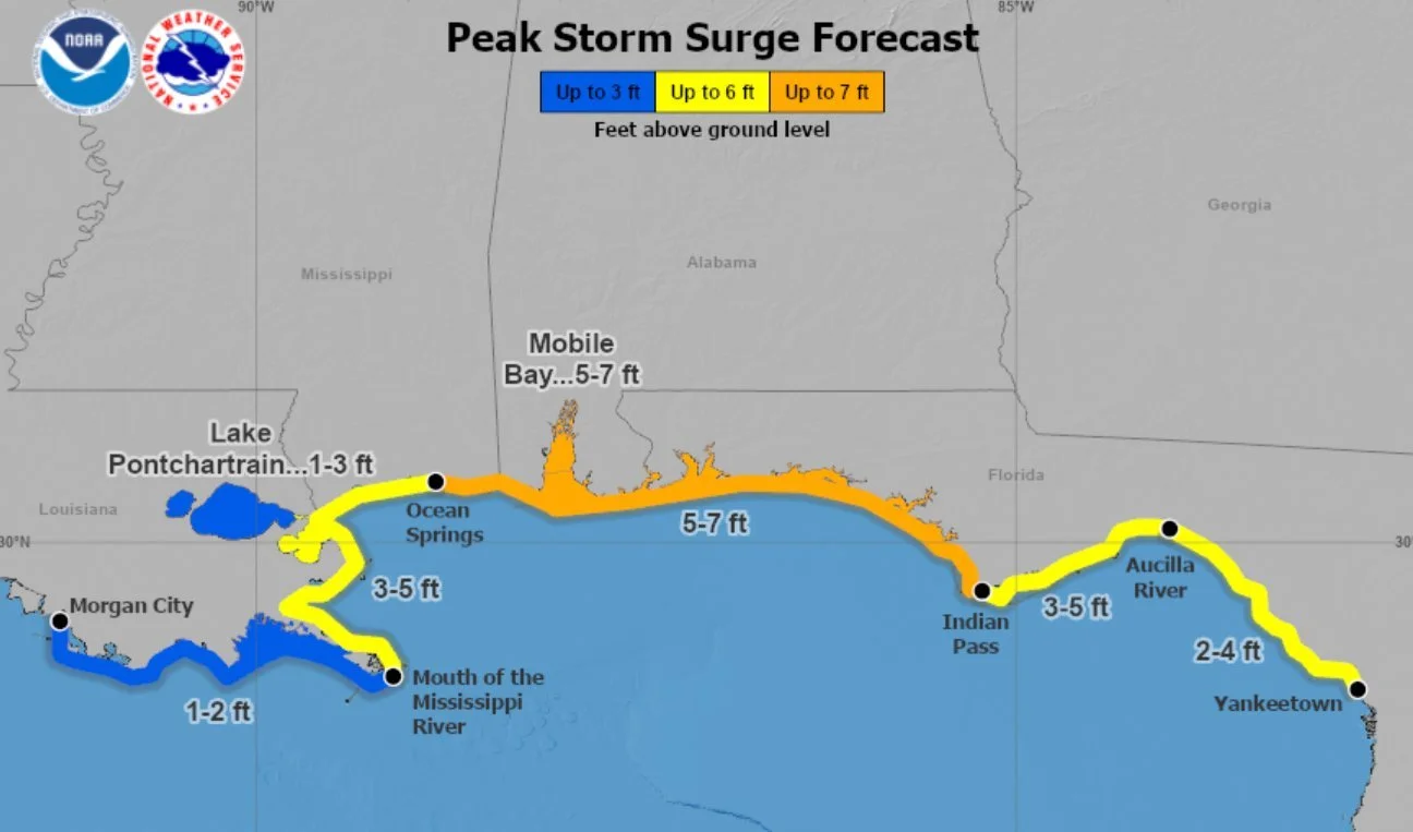
Storm surge is a big concern for the central Gulf coast with potential landfall of Isaias in that vicinity and it can be troublesome all the way from Texas to Florida. Map courtesy NOAA
Stay tuned and monitor closely...the tropics are alive and well.
Meteorologist Paul Dorian
Arcfield
arcfieldweather.com
Follow us on Facebook, Twitter, YouTube
Video discussion: