***Buckle up, it’s going to be a bumpy ride…stormy weather pattern - enhanced by a very strong El Nino - is about to get underway***
Paul Dorian
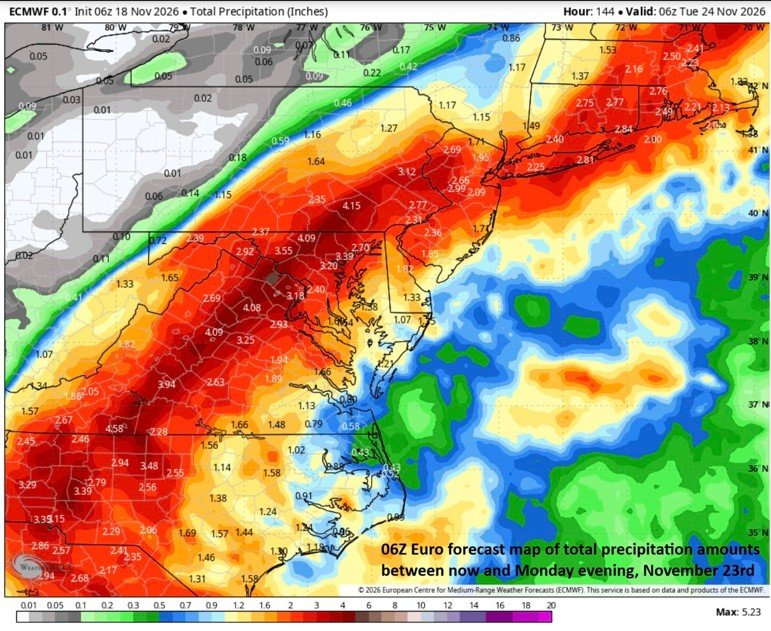
A strong coastal low is likely to ride right up along the eastern seaboard this weekend and it can generate significant rainfall in the Mid-Atlantic region on Sunday. Before climbing up the coast, this system is liable to produce 6+ inches of rainfall in portions of eastern Florida. Map courtesy ECMWF, Weather Bell Analytics
Overview
The overall weather pattern continues to look more active next week, and this could be the opening salvo in what appears to be a stormy winter season across the nation in large part due to the very strong El Nino event in the tropical Pacific Ocean. Strong El Nino increases the odds of a stormy winter weather pattern for multiple reasons including its tendency to amplify the sub-tropical jet stream that typically sets up across the southern states. An amplified sub-tropical jet stream in the winter acts as a high-altitude "conveyor belt" that taps into rich tropical moisture (enhanced through evaporation by the warmer-than-normal waters of El Nino) and channels it directly into contrasting mid-latitude air masses. In the medium term, a storm is going to pull out of the southeast US this weekend and likely ride up along the eastern seaboard potentially bringing significant rainfall to the Mid-Atlantic region on Sunday ending this latest dry stretch. Beyond that, there can be additional storm systems to deal with from later next week right into the first week of December…perhaps just the beginning of a very active winter season.
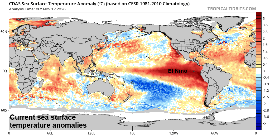
El Nino continues to dominate the scene in the tropical Pacific Ocean with water temperatures well above normal from the central Pacific to the west coast of South America (shown in orange). This very strong El Nino event will help to activate the southern branch of the jet stream likely leading to a very stormy weather pattern across the nation this winter season. Map courtesy NOAA, tropicaltidbits.com
Details
El Nino is correlated with warmer-than-normal water temperatures in the tropical Pacific Ocean which tends to lead to increased evaporation and higher moisture levels in the tropics. This enhanced moisture field helps to amplify the sub-tropical jet stream during the northern hemisphere winter season, and the result may be numerous storm systems pushing into the continental US from the eastern Pacific Ocean. Chances are rather high that overall precipitation amounts will exceed the norm this winter season across the western US with soaking rains in low-lying areas and substantial snow across higher elevation locations such as the Sierra Nevada Mountains of eastern California. In fact, just the next few days could feature as much as 5 feet of snow in the Sierras and 2+ inches of rain in low lying areas of California.
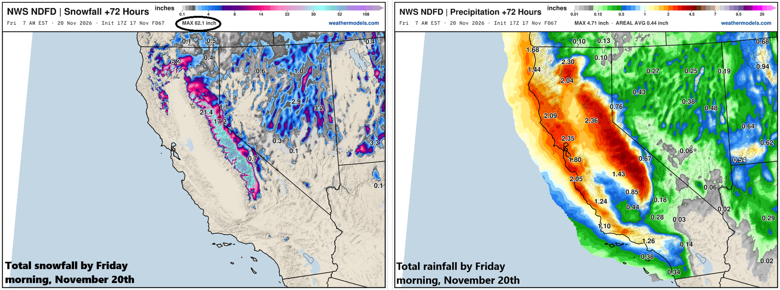
The next few days will feature a major storm system for California - typical of a very strong El Nino episode - with significant rain across low lying areas and substantial snow in the mountains. In fact, as much as 5 feet of snow is possible by the weekend across the higher elevations of the Sierra Nevada Mountains in the eastern part of the Golden State. Maps courtesy NOAA, weathermodels.com
Farther east, numerous storms this winter season are likely to also enhance precipitation chances across much of the southern and eastern US and soaking rains in many low-lying areas and above-normal snowfall is quite likely in many of the interior higher elevation locations such as the Appalachian Mountain chain all the way from Tennessee Valley to New England.
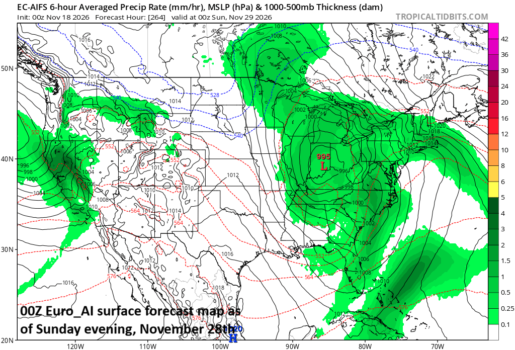
After this weekend’s coastal storm, the next system in a series of potential storms could impact the Mid-Atlantic region and Midwest during the latter part of next week. Map courtesy ECMWF, tropcialtidbits.com
After a few more quiet days in the eastern US, a storm system looks like it’ll ride up along the eastern seaboard this weekend and, after producing soaking rainfall in parts of the Southeast US (6+ inches in eastern Florida), rain is likely in the Mid-Atlantic region on Sunday, and it could be heavy at times. After that, there are signs for a parade of storms from later next week right into the first week of December…all riding along an activated sub-tropical jet stream...and this is very likely not to be the end of the active weather pattern.
Buckle up, it’s going to be a bumpy ride.
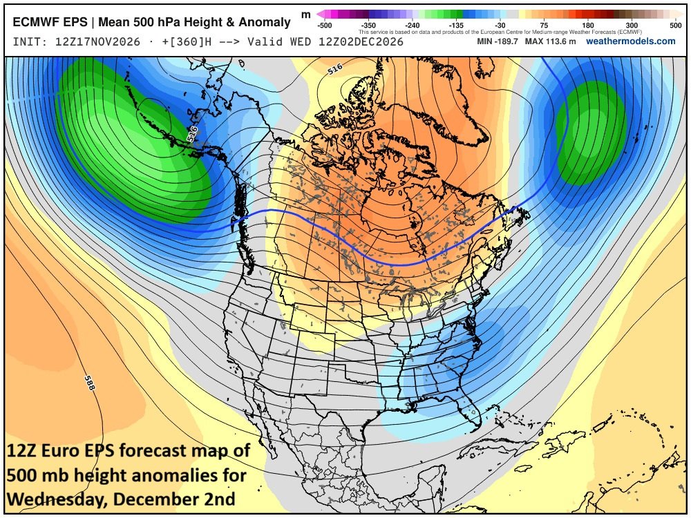
In the more speculative longer-range, there are signals for another possible storm system in the eastern US during the beginning part of December. This forecast map of 500 mb height anomalies for the Wednesday, December 2nd time period features a strong upper-level trough centered near the east coast (shown in blue) with strong ridging over Canada (shown in orange). This combination can certainly produce another strong storm system to deal with in early December somewhere in the eastern states. Map courtesy ECMWF, weathermodels.com
Meteorologist Paul Dorian
Arcfield
arcfieldweather.com