****Bitter cold this weekend with a direct discharge of Arctic air from eastern Canada...snow showers and possible squalls with Arctic front...powerful winds on both weekend days****
Paul Dorian

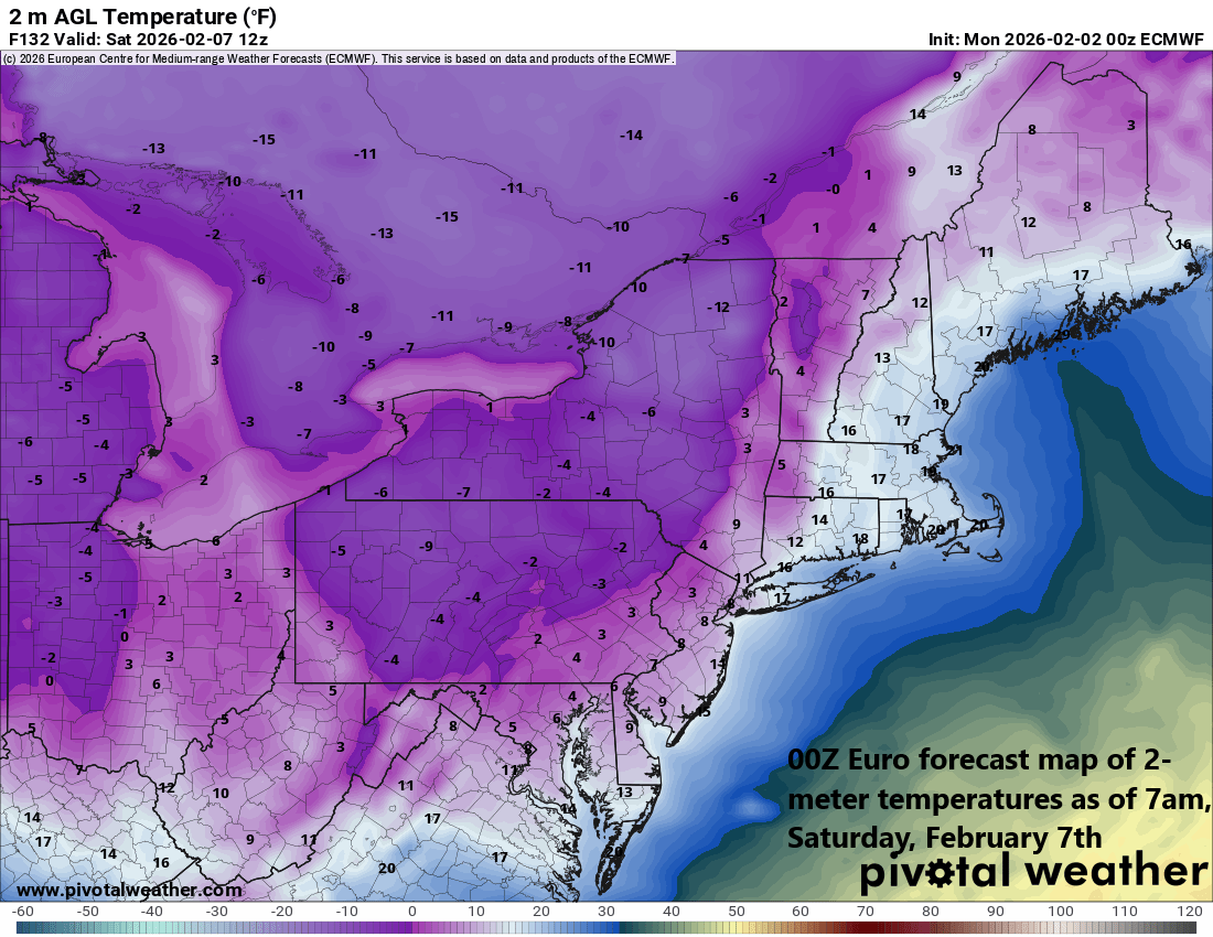
With the direct discharge of Arctic air this weekend from eastern Canada into the northeastern US, overnight lows are again likely to fall into single digits in much of the I-95 corridor and daytime highs might do no better than the teens. Map courtesy ECMWF, Pivotal Weather
Overview
Punxsutawney Phil saw his shadow this morning suggesting there will be six more weeks of winter, and I certainly have faith in all Pennsylvania prognosticators. One thing is for sure...the next 7 days will feature more in the way of well below-normal temperatures, and the upcoming weekend will be bitterly cold across the Mid-Atlantic/Northeast US with a direct discharge of Arctic air from eastern Canada. The Arctic front at the leading edge of this brutally cold air mass can produce snow showers and squalls on Friday, and powerful winds will add to the misery on both weekend days. The big cities from DC-to-Boston will likely experience single digit lows once again during the weekend and wind chills will be at dangerously low levels on both days.
A direct discharge of Arctic air takes place this weekend from eastern Canada into the northeastern US with a north-to-south flow of low-level air. Map courtesy ECMWF, Pivotal Weather
Details
Temperatures have a chance (finally) of reaching the freezing mark for afternoon highs later today in DC and on Tuesday in Philly and NYC; however, by the time the weekend rolls around, we’ll likely be dealing with the teens again for afternoon highs. This return to brutal cold will be the result of a direct discharge of Arctic air from eastern Canada into the Mid-Atlantic/Northeast US and this kind of trajectory of low-level flow has often resulted in some of the lowest temperatures observed in this part of the country.
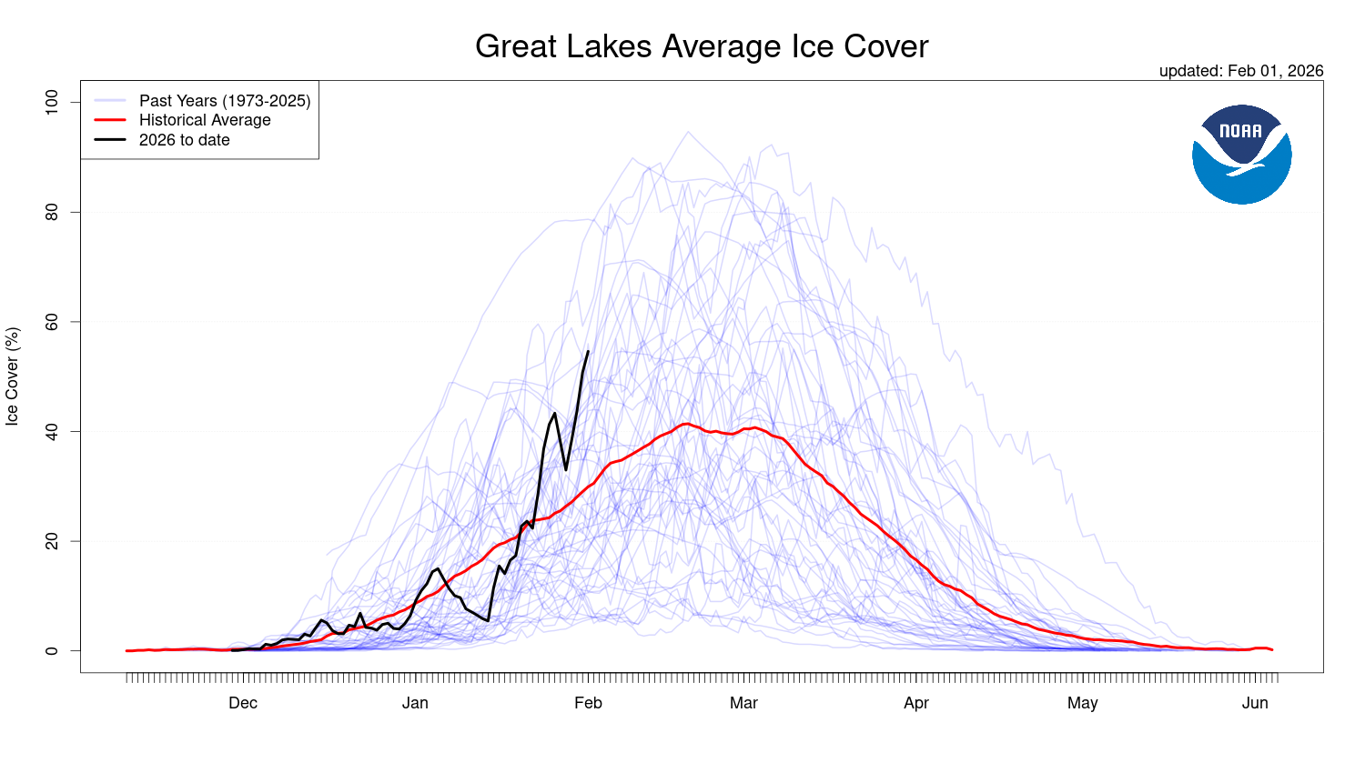
While well above-normal, ice cover on the Great Lakes is only partial as we enter February. In the conventional Arctic air outbreak for the northeastern US, the flow of air is from a northwesterly direction and this unfrozen lake water would have a modifying effect. In the weekend scenario, the low-level flow of air will likely be from a northerly direction and this will inhibit the modifying effects of the Great Lakes. Map courtesy NOAA
The more conventional wind flow for Arctic air to flow into the Mid-Atlantic/NE US is from a northwesterly direction, and this allows the air to modify some while crossing over the partially unfrozen Great Lakes. In addition, a northwesterly flow of air will descend the Appalachian Mountains (known as “downsloping”) and this results in some modification of temperatures as the air reaches the coastal plain. In the case with a direct discharge of Arctic air from eastern Canada into the Mid-Atlantic/NE US, these “modification” processes are greatly inhibited and this trajectory has resulted in some of the lowest temperatures recorded in places like New York City and Boston.
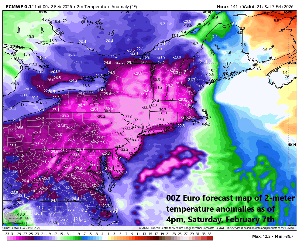
Temperatures will be far below-normal this weekend with a direct discharge of Arctic air from eastern Canada into the Mid-Atlantic/Northeast US. Map courtesy ECMWF, Weather Bell
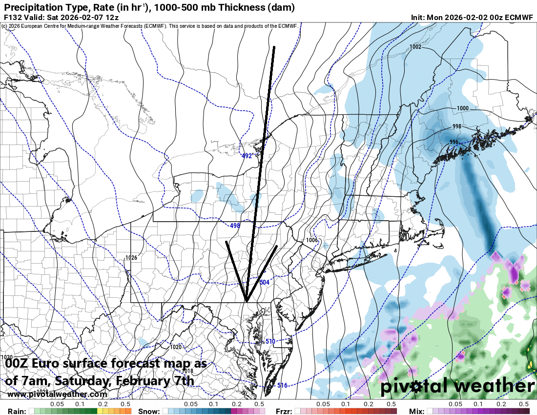
The Arctic front at the leading edge of the intensely cold air mass will cross the Mid-Atlantic/Northeast US later Friday and it can be accompanied by snow shower activity...even in the immediate I-95 corridor. In fact, the atmosphere is liable to become unstable enough to add the possibility of snow squalls on Friday...something we’ll have to better assess as we closer to the event.

Punxsutawney Phil saw his shadow this morning indicating there will be six more weeks of winter…have faith in all Pennsylvania prognosticators.
Over the weekend, the overall weather pattern will feature a deep upper-level low sitting over the northeastern states, and the surface will feature an intense departing low pressure system and a strong incoming high pressure. As a result, the pressure gradient between these two systems will become tight enough to result in powerful winds on both weekend days throughout the Mid-Atlantic region and Northeast US. The combination of powerful winds and temperatures likely doing no better than the teens for afternoon highs would result in dangerously low wind chill factors on both Saturday and Sunday.
Any good news? Yes, a warmup is likely by the middle and latter parts of next week and pitchers and catchers report to spring training in a week to ten days.
Meteorologist Paul Dorian
Arcfield
arcfieldweather.com
Follow us on Facebook, Twitter, YouTube
Video discussion: