***Significant severe weather threat next couple of days associated with powerful cold front...southern Plains to Upper Midwest later today...Lower MS Valley to Mid-Atlantic later tomorrow***
Paul Dorian

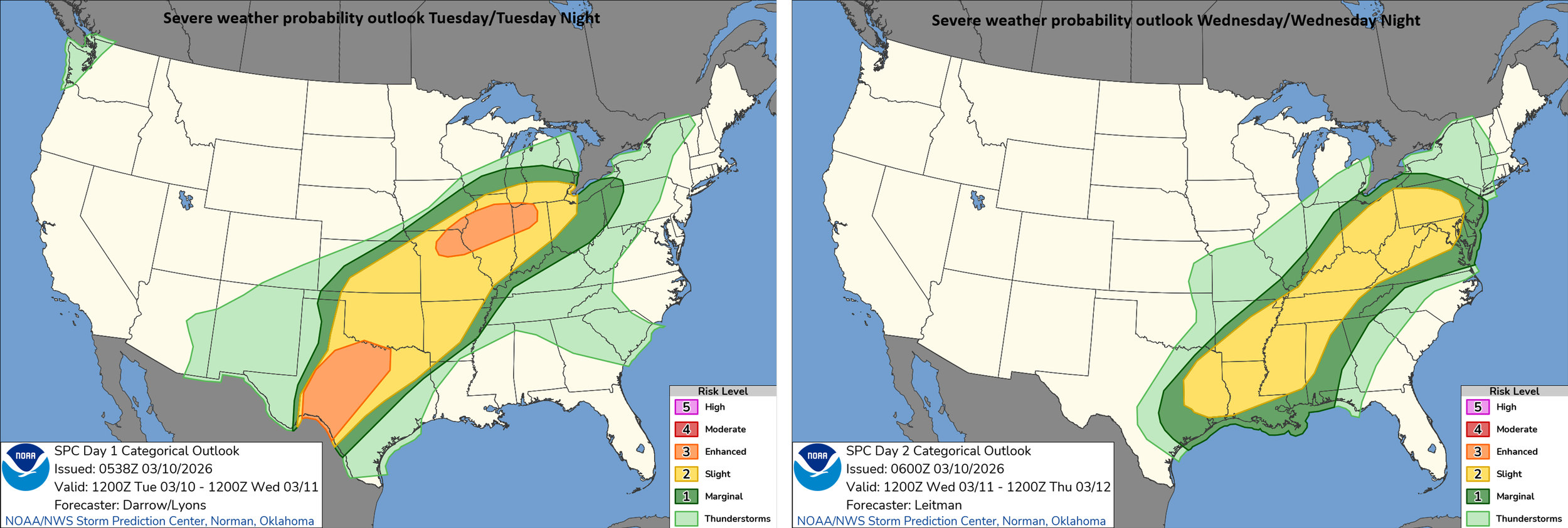
A significant severe weather event is in the offing for later today and tonight extending from the southern Plains to the Upper Midwest. The severe weather threat shift east on Wednesday with the risk zone to include the region from the Lower Mississippi Valley to the Mid-Atlantic. Maps courtesy NOAA/SPC
Overview
A significant severe weather threat exists for later today and tonight in the region from the southern Plains to the Upper Midwest and this risk which includes possible tornadoes will shift east later tomorrow to an area that extends from the Lower Mississippi Valley to the Mid-Atlantic region. Numerous ingredients are coming together for this severe weather threat including a powerful surface cold front, warm and humid air in place, waves of energy aloft in both the northern and southern jet streams, and an incoming colder-than-normal air mass. After possible record-breaking warmth during the next two days in the Mid-Atlantic region, it’ll turn much cooler for Thursday and Friday following the passage of the strong cold front, and a widespread colder-than-normal air mass will push into the eastern states early next week.
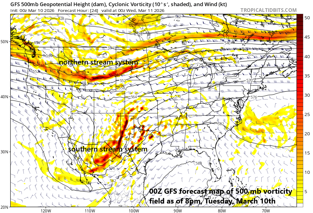
There are two waves of energy aloft that will help to destabilize the atmosphere later today and tonight. The first in riding along the northern jet stream and it will enhance the chance of severe weather across the Upper Midwest including in and around the Chicago metro region. The second system will push along the southern branch of the jet stream and enhance the chance of severe weather later today/tonight across Texas including in and around the Dallas metro. Map courtesy NOAA, tropicaltidbits.com
Severe weather threats for the next two days
Numerous ingredients are coming together to increase the chance of a significant severe weather event from later today into late tonight in the region from the southern Plains to the Upper Midwest and this includes the risk of tornadic activity. A split flow upper air pattern persists today across the continental US, and two separate waves of energy will play crucial roles in the potential severe weather outbreak with one pushing system along the northern jet stream now located over Montana and a second wave now over Baja Peninsula riding along the southern branch. This northern wave of energy will enhance the threat later today and tonight across the Upper Midwest including the Chicago metro region and the southern wave will enhance the threat across much of Texas including the Dallas area.
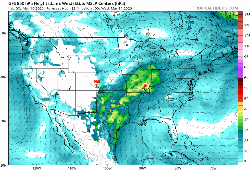
A strong low-level jet will play a crucial role in the severe weather threat both later today and later tomorrow. This strong jet streak will add to the overall shear in the atmosphere raising the chance of tornadic activity including in the overnight hours. Maps courtesy NOAA, tropicaltidbits.com
In addition to the upper-level waves of energy, other ingredients will help to destabilize the atmosphere later today and tonight including a strong low-level jet, an influx of warm and humid air from the south and east, and an influx of colder-than-normal air from the north and west.
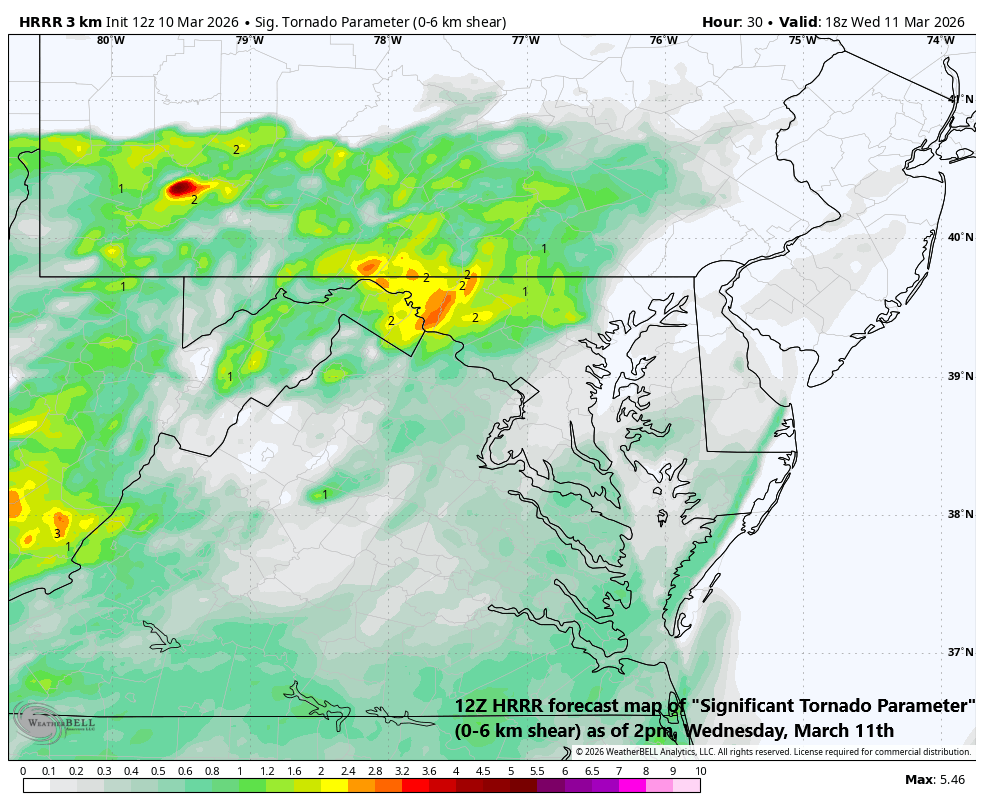
The severe weather threat during the next couple of days will include a risk of tornadoes and that’ll pertain to the Mid-Atlantic region later tomorrow/tomorrow night where low-level wind shear will become quite high. Map courtesy NOAA, Weather Bell, Tony Pann (X)
On Wednesday, as the surface cold front advances to the east, so will the severe weather threat...this time extending from the Lower Mississippi Valley to the Mid-Atlantic region. As will be the case later today, numerous severe weather ingredients should come together later tomorrow and tomorrow night to produce severe thunderstorms and tornadoes will again be a risk. One of the questions regarding the risk of severe weather in the Mid-Atlantic region on Wednesday will be whether morning/mid-day showers actually develop which could inhibit destabilization of the atmosphere in the area. If these early-to-midday showers fail to materialize then the atmosphere could become quite unstable by the afternoon and evening hours. By Thursday morning, the strong cold front will reach the eastern seaboard, and it’ll turn quite breezy and much cooler in the Mid-Atlantic region with a sharp drop in temperatures compared to the potential record-breaking warmth to be experienced at mid-week.

A widespread colder-than-normal air mass will push into the eastern US early next week and the overall weather pattern will become quite reminiscent of much of the winter season with warmer-than-normal conditions in the western states and colder-than-normal across the east. Map courtesy ECMWF, polarwx.com (Tomer Burg, X)
Widespread cold air outbreak early next week
Looking ahead, all signs point to a widespread cold air outbreak early next week across the eastern states with a colder-than-normal air mass dropping southeast from central Canada. Another strong cold front will show up on the scene later in the weekend and this looks like it’ll be quite an active system with the chance of severe weather in its warm sector and the possibility of some accumulating snow for some areas in its cold sector. In fact, the general pattern that appears to be unfolding for next week will be reminiscent of the pattern seen during much of the winter with strong high pressure ridging centered over the western states and an upper-level trough of low pressure positioned over the eastern US.
Meteorologist Paul Dorian
Arcfield
arcfieldweather.com
Follow us on Facebook, Twitter, YouTube
Video discussion: