
****March Madness...record-warmth...severe weather threat...accumulating snow likely on Thursday in the Mid-Atlantic ...late weekend Great Lakes blizzard...widespread cold air outbreak next week****
Paul Dorian
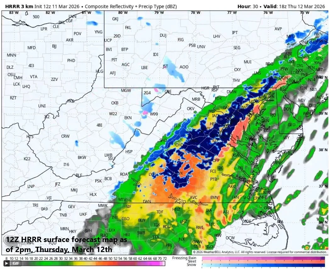
Temperatures will plunge on Thursday in the Mid-Atlantic region and precipitation behind a strong cold front could change to snow for parts of the area and small accumulations cannot be ruled out. Map courtesy NOAA, Weather Bell
Overview
March is known for some wild swings in the weather, and this one looks like it will not disappoint. Temperatures peaked at record-breaking levels on Tuesday in the Mid-Atlantic region and included the earliest observation of 80 degrees in New York City’s Central Park. Severe weather broke out on Tuesday afternoon and evening across the Upper Midwest with tornadoes reported across parts of Illinois and Indiana and severe thunderstorms will be possible today from the Mid-Atlantic region and Ohio Valley to the Lower Mississippi Valley and again tornadoes will be on the table. A strong cold front pushes through the Mid-Atlantic region early Thursday and there is the chance that rain can mix with or change to snow in parts of the area by the late morning or midday hours following right on the heels of the record-breaking warmth…small accumulations of a coating to an inch or two cannot be ruled out.
Over the weekend, another strong cold front will enter the picture across the nation’s midsection with a widespread colder-than-normal air mass on its backside and charging to the south and east. A strong storm system is likely to form along the frontal boundary zone as upper-level support arrives, and the Great Lakes may end up with an all-out blizzard come late Sunday into Monday with plenty of snow and powerful winds. In fact, there can be accumulating snow and strong winds in this same Great Lakes region on Friday from a clipper-system and this would just be an appetizer for the potential late weekend blizzard. The widespread colder-than-normal air mass reaches the eastern states by late Monday and the 20’s and 30’s will be commonplace in the Mid-Atlantic region by the time we get to next Tuesday for afternoon highs...a far cry from the past couple of days. Looking ahead, as is often the case during the month of March, the early-to-mid week cold snap in the eastern states may change dramatically to much milder conditions by the end of next week and yes, this wild weather pattern can flip again with yet another widespread cold air outbreak later in the month.

Severe weather is a threat today from the Mid-Atlantic/Ohio Valley to the Lower Mississippi Valley and this includes the risk of tornadoes. Map courtesy NOAA/SPC
Record-warmth and severe weather
Temperatures climbed dramatically on Tuesday in the Mid-Atlantic region to record high levels in Washington, D.C., Baltimore, Philadelphia and New York City. The record highs included 84 degrees at Reagan National Airport (DCA), 85 degrees at Dulles (IAD), 85 degrees at BWI in Baltimore, 83 degrees in Philly (PHL) and 80-degrees in Central Park (NYC) which was their earliest ever observation of 80-degrees. Today will again feature spring-like warmth in the Mid-Atlantic region ahead of a strong cold front and records are possible in a few spots, but the abundance of clouds will limit the extremes that were experienced on Tuesday.
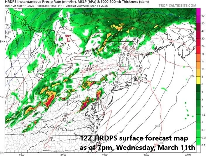
There is the threat of severe weather in much of the DC-to-Philly-to-NYC corridor later today/early tonight with tornadoes on the table. The most likely time period for the severe weather in the I-95 corridor is 5 to 9pm on Wednesday, March 11th. Map courtesy NOAA, weathermodels.com
The approaching strong cold front contributed to a severe weather outbreak on Tuesday across the Upper Midwest with a breakout of tornadoes across Illinois and Indiana. A pre-frontal trough out ahead of the cold front today will play key role in the destabilization of the atmosphere across the Mid-Atlantic region potentially leading to strong-to-severe thunderstorms this afternoon and evening and isolated tornadoes cannot be ruled out. Today’s severe weather threat will not only include the Mid-Atlantic region, but also the Ohio, Tennessee, and Lower Mississippi Valleys where severe thunderstorms and tornadoes are also on the table.
In an example of true March Madness, the Mid-Atlantic region can switch from record-breaking warmth in the 80’s to accumulating snow on Thursday following the passage of a strong cold front. Map courtesy NOAA, Weather Bell
Much colder on Thursday...snow possible in parts of the Mid-Atlantic...
Small accumulations cannot be ruled out
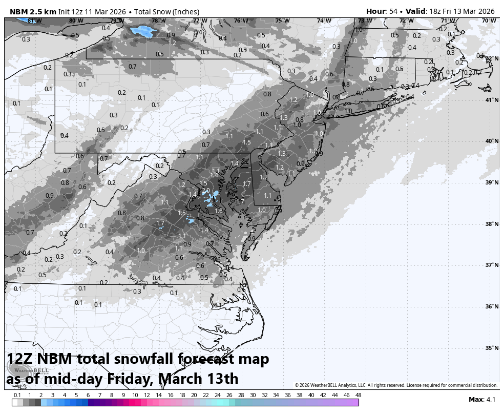
The strong surface cold front will barrel through the Mid-Atlantic region early Thursday accompanied by rain showers and temperatures will drop through the 40’s in the DC-to-Philly-to-NYC corridor. In fact, there may be enough precipitation on the back side of the front (i.e., in the cold sector) for a mixing with or changeover to snow in parts of the Mid-Atlantic region by the late morning or mid-day hours on Thursday and small accumulations cannot be ruled out on the order of a coating to an inch or two...quite a change from the record-warmth. (The snow could actually stick on Thursday despite the recent excessive warmth as it would likely be of the heavy, wet variety). It stays chilly on Friday and cool to begin the upcoming weekend with generally dry conditions expected on both Friday and Saturday.
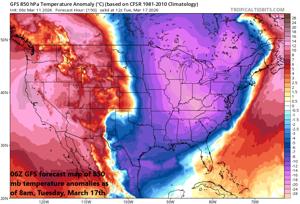
Widespread colder-than-normal air will push into the eastern states by later Monday and highs temperatures on Tuesday in the Mid-Atlantic region could be confined to the 20’s and 30’s. Map courtesy NOAA, tropicaltidbits.com
Widespread cold air outbreak arrives later Monday...
20’s/30’s on Tuesday in much of the Mid-Atlantic region for afternoon highs
Another strong cold front will reach the middle of the nation this weekend and it’ll be at the leading edge of a widespread colder-than-normal air mass that had its origins way up in Canada. This colder-than-normal air mass will plunge southward into the Northern Plains on Sunday and then spread to the south and east on Sunday night and Monday. Showers and thunderstorms are likely to form along and just ahead of this strong cold front and like the current setup, severe weather may develop in some areas. The cold front reaches the eastern seaboard during the day on Monday, and much colder conditions are expected here by Monday night and Tuesday with the 20’s and 30’s commonplace for high temperatures by Tuesday afternoon...a far cry from the 80’s of this week. In addition, winds will likely be quite strong on Tuesday producing even lower wind chill values compared to the actual ambient temperatures and a snow shower or two will be possible.
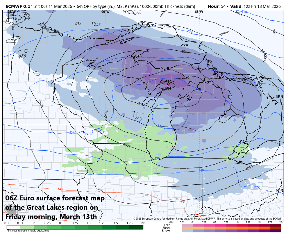
A clipper-like system will push across the Great Lakes region on Friday likely with strong winds and accumulating snow. Map courtesy ECMWF, Weather Bell
Great Lakes late weekend blizzard (and a preceding Friday snowstorm)
The strong cold front that reaches the middle of the nation on Sunday will feature a sharp temperature gradient at surface level and there will be lots of support aloft with a deepening upper-level trough of low pressure moving overhead. Surface low pressure will deepen dramatically by later Sunday/Sunday night over the Great Lakes, likely leading to an all-out blizzard into Monday with substantial snowfall and powerful winds potentially reaching 60+ mph.

Ingredients may come together for an all-out Great Lakes blizzard from later Sunday into Monday featuring powerful winds and substantial snow. Map courtesy ECMWF, Weather Bell
Much of this same Great Lake’s region may actually experience accumulating snow and strong winds on Friday as an appetizer to the main event which comes from late Sunday into Monday. A clipper system will move through the area on Friday and likely produce accumulating snow some two days ahead of the potential late weekend blizzard. The combination of these two storms may end up resulting in 1-2 feet of snow across portions of the Great Lakes by the time we get to the early part of next week...welcome to March Madness.
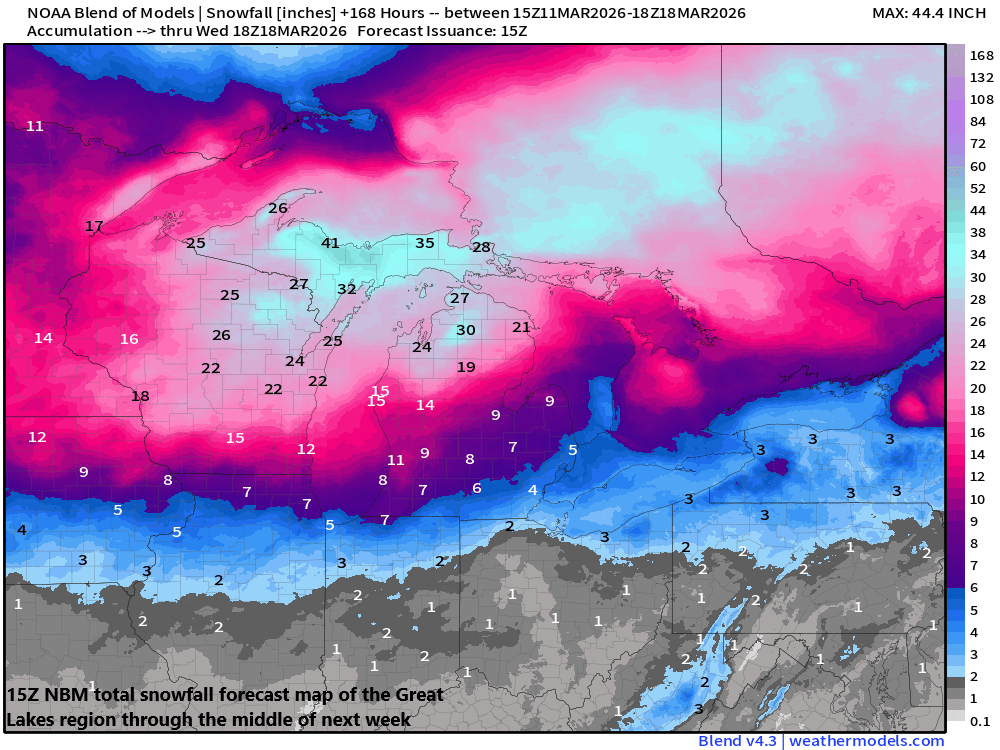
The Great Lakes region may get pounded by snowfall from two separate storm systems in coming days. The first will be a clipper-system that pushes across the area on Friday with accumulating snow, and the second could turn out to be an all-out blizzard later Sunday into Monday with substantial snow and powerful winds. Map courtesy NOAA, weathermodels.com (Dr. Ryan Maue, X)
Meteorologist Paul Dorian
Arcfield
arcfieldweather.com
Follow us on Facebook, Twitter, YouTube
Video discussion: