
**Cooler-than-normal pattern across much of the eastern half of the nation to at least the middle of May...cooler pattern will come with multiple rain opportunities**
Paul Dorian
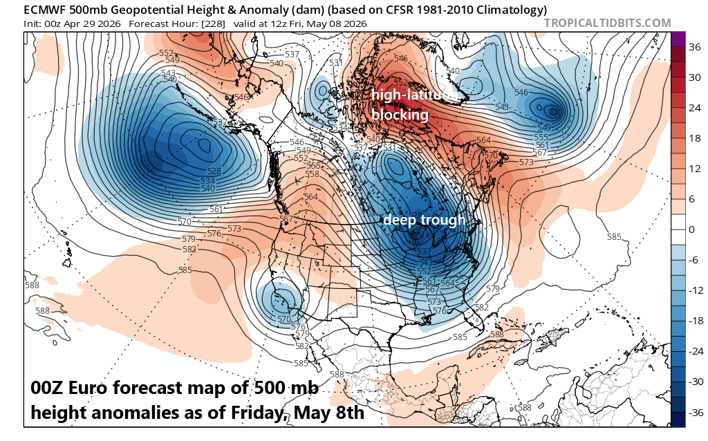
The upper air pattern across North America during the next couple of weeks (at least) will feature a long-wave trough of low pressure (shown in blue) centered near the Great Lakes and “high-latitude blocking” (shown in orange) over northeastern Canada and Greenland. This kind of pattern is favorable for the transport of cooler-than-normal air masses from central Canada into the northern US. In addition, multiple rain events are on the table in parts of the eastern US during the next couple of weeks. Map courtesy ECMWF, tropicaltidbits.com
Overview
May gets underway on Friday, and it looks like a cooler-than-normal pattern will dominate in the eastern half of the nation to at least the middle of the new month. Multiple cooler than normal air masses are likely to push into the north-central states from central Canada during those next couple of weeks and these will ultimately spread to the south and east and encompass the Great Lakes, Mid-Atlantic, and Northeast US. A favorable pattern for the transport of cooler-than-normal air masses from Canada into the US will feature a persistent upper-level trough centered near the Great Lakes as well as some “high-latitude blocking” up across northeastern Canada and Greenland. In addition to the expected cooler conditions, multiple rain events are on the table during the next couple of weeks beginning with one from later today into early Thursday which will impact the Mid-Atlantic region.
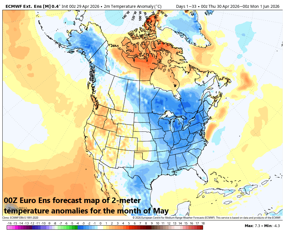
All indications are for cooler-than-normal conditions to persist across much of the eastern half of the nation well into the month of May. This long-range forecast of 2-meter temperature anomalies for the full month of May supports this idea. Map courtesy ECMWF, Weather Bell Analytics
Details
Some snow lovers in the northeastern part of the nation may end up thinking that this kind of unfolding upper-air pattern would have been great if it were the middle of the winter season and not the beginning of May. Multiple cooler than normal air masses are destined to reach the northeastern states during the next couple of weeks and this overall pattern will likely include some beneficial rain events and also the chance for more frost across interior sections. Indeed, one such cooler-than-normal air mass will arrive on Thursday following the passage of a strong cold front and temperatures are likely to fall into the upper 30’s late tomorrow night across some suburban locations in the I-95 corridor. The strong cold front will be preceded by a beneficial rainfall for the DC-to-Philly-to-NYC corridor in the period from later today to early Thursday and there can be some strong-to-severe thunderstorm activity in the mix; especially to the south of the PA/MD border (e.g., D.C., Baltimore). Additional rain events are likely during this cooler weather pattern in parts of the eastern US as we progress through at least the first half of the new month.
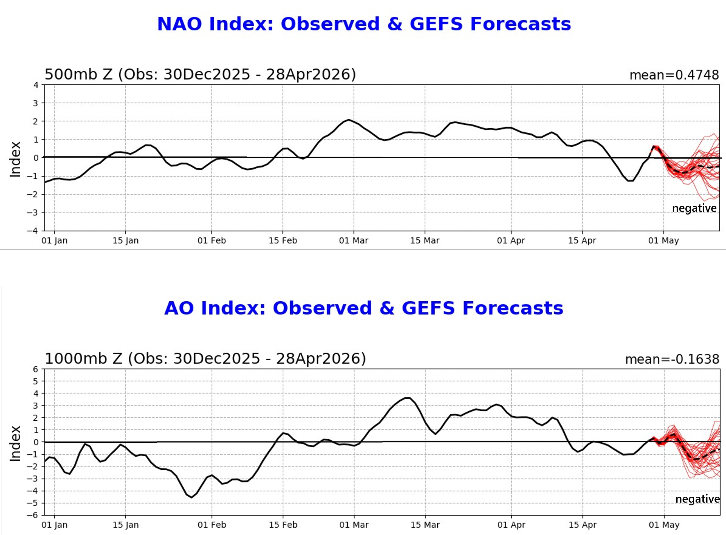
A cooler-than-normal weather pattern is setting up for much of the eastern half of the nation that will likely carry us to at least the middle of May - and potentially through the entire month. The upper air pattern will feature a persistent long-wave trough of low pressure centered over the Great Lakes region as well as “high-latitude blocking” over northeastern Canada and Greenland…a pattern supported by the “negative” trend of the AO and NAO (see “red” on plots). Maps courtesy NOAA
This incoming cooler-than-normal air mass will not be the last for the northeastern part of the country as a long-wave trough of low pressure sets up across the eastern half of the nation at the same time “high-latitude blocking” (i.e., higher heights and pressures than normal) sets up across northeastern Canada and Greenland. This kind of upper air pattern is favorable for the transport of cooler-than-normal air masses from Canada into the northern US and it looks like it’ll persist into at least the middle of May and perhaps right through the entire month. Teleconnection indices such as the Arctic Oscillation (AO) and its closely related cousin known as the North Atlantic Oscillation (NAO) support the notion of “high-latitude blocking” as they both will be in “negative” territory through much of the first half of May...usually a trend that is well correlated with cooler-than-normal conditions across the eastern half of the nation.
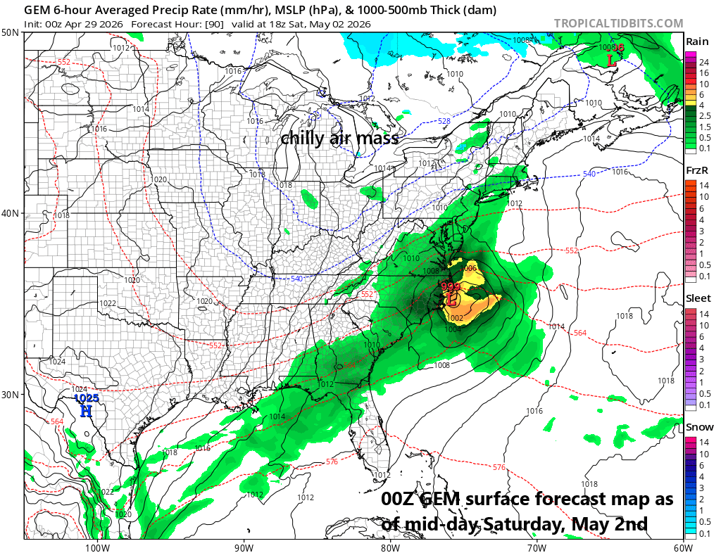
A cooler-than-normal weather pattern will likely include multiple rain events for the eastern states during the next couple of week beginning with one impacting the Mid-Atlantic region from later today into early Thursday as a strong cold front approaches the area. Looking ahead, a storm system will slide to a position just off the Mid-Atlantic coastline on Saturday and it can bring some rain as far north and west as the the DC-to-Philly-to-NYC corridor…still a close call. Map courtesy Canadian Met Centre, tropicaltidbits.com
As far as additional rain events are concerned, there is the chance for some rain on Saturday in the DC-to-Philly-to-NYC corridor as intensifying low pressure slides to a position just off the Mid-Atlantic coastline, but there is also the chance that its precipitation shield stays just to the south and east of here. No matter what the final result is in terms of rainfall, the upcoming weekend will be on the cool side of normal in the Mid-Atlantic region and look for many additional cooler-than-normal days as we progress through the first half of the new month.
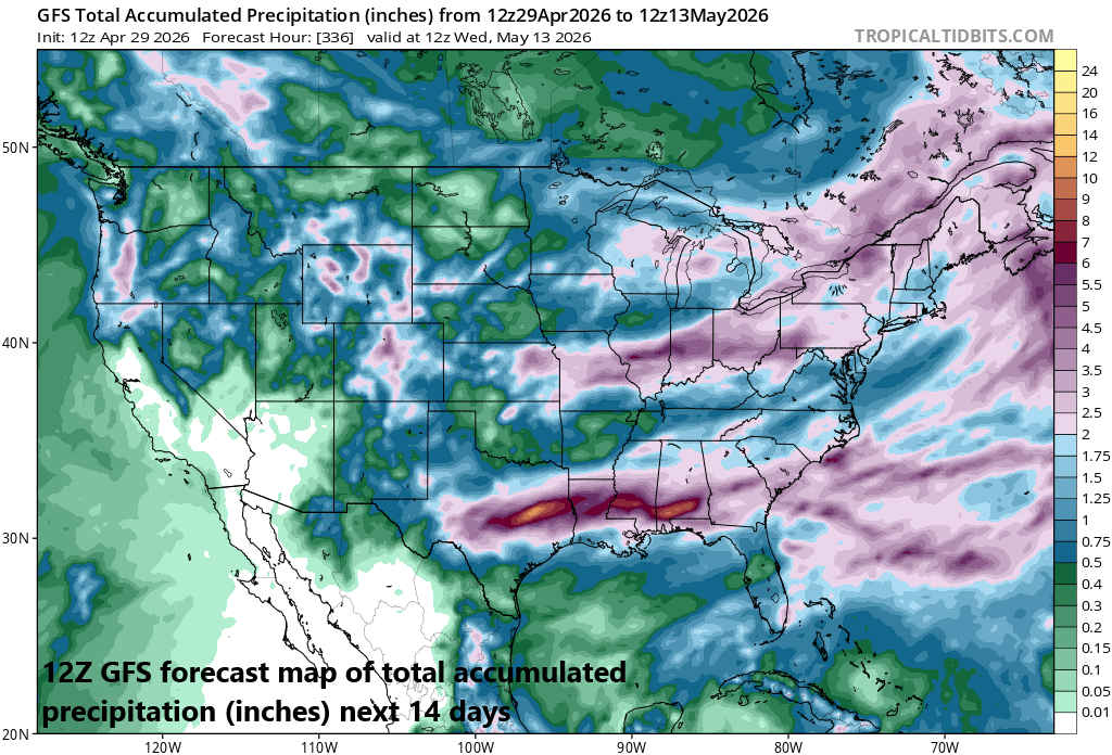
There will be multiple rain opportunities in the eastern half of the nation during the next couple of weeks - all welcomed news - and this forecast map of total amounts during the next 14 days suggest many areas will see at least 2 inches. Map courtesy NOAA, tropicaltidbits.com
One final note, as long as cooler-than-normal outbreaks make their way from Canada into the northern US, the chance for severe weather outbreaks will remain on the table. This type of pattern will increase the prospects for “clashes” to set up in the atmosphere between the incoming chilly air charging to the south and east and warmer air situated across the Deep South supported by the increasingly strong effects of the sun.
Meteorologist Paul Dorian
Arcfield
arcfieldweather.com
Follow us on Facebook, Twitter, YouTube
Video discussion: