*No hurricanes so far in the 2026 Atlantic tropical season and that puts us in rare territory...there are some signals, however, for activity going forward*
Paul Dorian
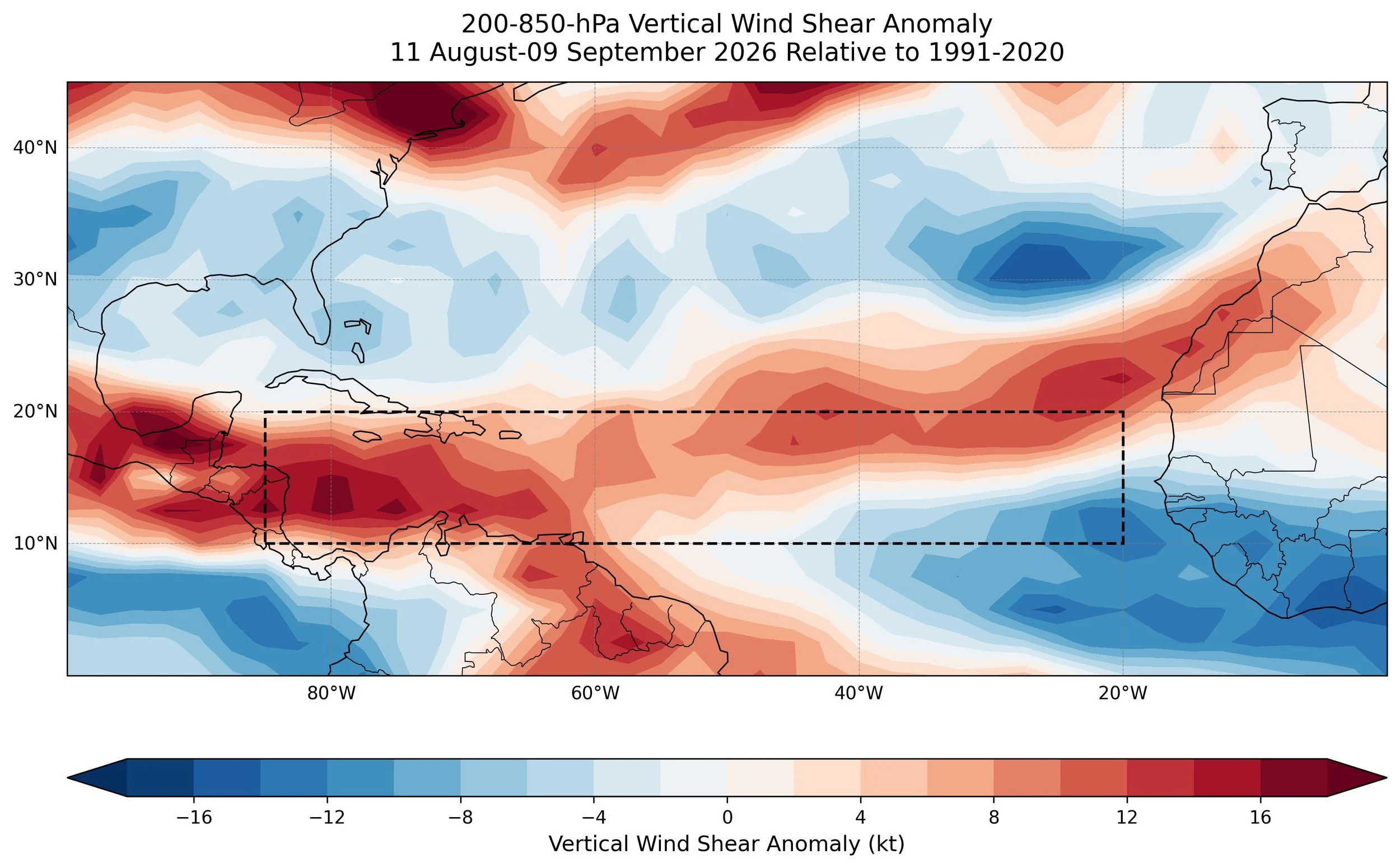
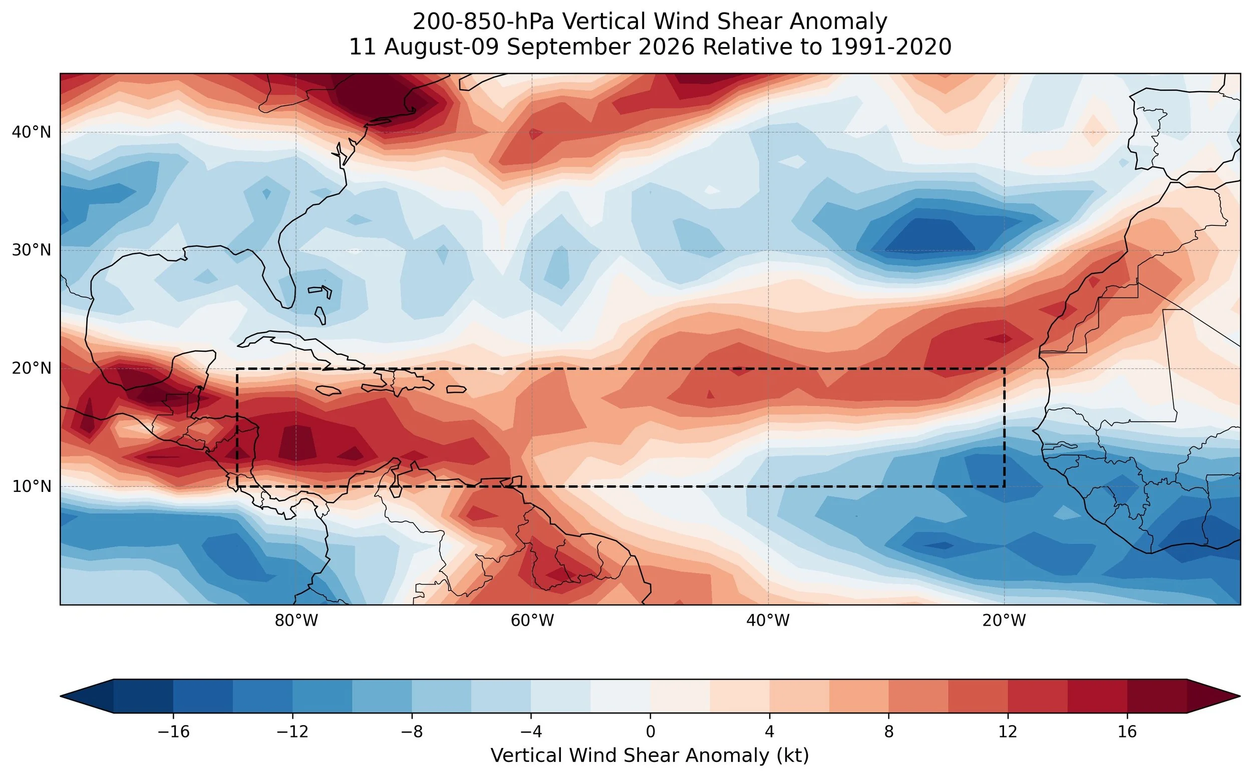
One of the significant impacts of an El Nino event in the tropical Pacific Ocean is increased vertical wind shear across the Atlantic Basin which is an inhibiting factor for tropical storm development or intensification. The last 30 days have seen well above normal vertical wind shear anomalies across the Atlantic’s Main Development Region (boxed region). Map courtesy NOAA, Dr. Philip Klotzbach (CSU)
Overview
We have now reached rare territory for the Atlantic Basin due to the lack of hurricanes at this stage of the tropical season. In fact, this is the latest time without an Atlantic hurricane during the satellite era which began in 1966 and there is likelihood that one has to go all the way back to 1941 though confidence in the tracking of hurricanes is far less certain in the pre-satellite era. Having said that, an extremely quiet first half of the tropical season does not guarantee an uneventful second half and there are some signals that activity will pick up later this month.
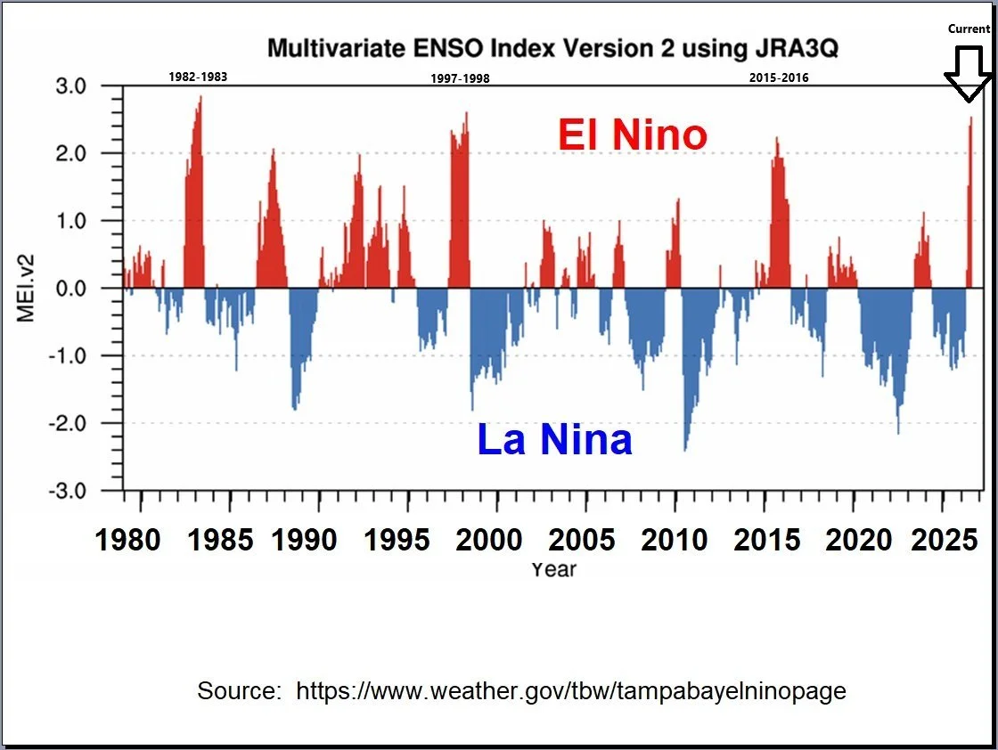
One way to track the magnitude of an El Nino is through an index known as the Multivariate ENSO Index or MEI. This particular Index is quite useful as it not only factors in sea surface temperature anomalies into its calculation, but also considers the response of the atmosphere. Using this metric, the current El Nino (far right) is on par with some of the great El Nino episodes during the last 50 years or so including 1982-1983, 1997-1998, and 2015-2016. Map courtesy NOAA
Details
One of the benefits of an El Nino event in the tropical Pacific Ocean is that it generally leads to a quieter Atlantic Basin tropical season due to an increase in vertical wind shear in the Atlantic Ocean’s Main Development Region, but what has happened so far this year has been pretty remarkable indeed. Vertical wind shear tends to suppress tropical cyclone development or intensification since it disrupts the circulation center of a tropical cyclone by tilting the storm’s vortex and often leads to an influx of cooler and dry air into the warm core. By passing by the specific date of September 11th without having the first hurricane in the Atlantic Basin, we have entered rare territory for being this late into the tropical season. There happened to be two “first” hurricanes that fell on September 11th - Gustav in 2002 and Humberto in 2013 – and now that we have past this point, we have gone as deep into the tropical season as ever recorded during the satellite era which began in 1966. In fact, there is reason to believe that we have to go all the way back to 1941 to match this kind of extreme quiet in the Atlantic Basin this late in the season though confidence is far less certain on the tracking of hurricanes in the pre-satellite era.
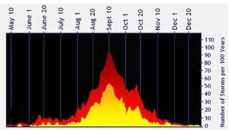
From a climatological point of view, the peak of the Atlantic Basin tropical season comes right around the 10th of September when sea surface temperatures are near their peak in much of the Atlantic Ocean’s Main Development Region. Plot courtesy NOAA
The climatological peak of the Atlantic Basin tropical season is right around the 10th of September so nearly half of the season remains and a quiet first half (albeit remarkedly quiet) does not guarantee an uneventful second half. Indeed, one of the important teleconnection indices that we follow this time of year is known as the Madden-Julian Oscillation (MJO) which tracks a tropical disturbance that propagates eastward on a regular basis over the tropics. Depending on the location or phase of this tropical disturbance, the chance of tropical activity in the Atlantic Basin can increase (or decrease) due to the positioning of strong upward (downward) motion in the atmosphere. Some of the most recent computer model forecasts suggest the MJO can rotate into phases 8, 1 and 2 during the next few weeks and these locations are usually favorable this time of year for increased upward motion in the Atlantic Basin and, in turn, increased chances for tropical storms and hurricanes.
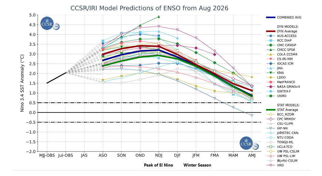
A compilation of sea surface temperature anomalies for the central Pacific Ocean (region 3.4) is shown here and many indicate El Nino during October or November of this year. In addition, there is widespread agreement that El Nino will continue into the winter season of 2026-2027 which would likely have a significant impact on the winter weather across the continental US. Map courtesy NOAA, ECMWF, JMA, NASA, IRI/CPC
So far this summer season, there have been five named tropical storms in the Atlantic Basin (Arthur, Bertha, Cristobal, Dolly, Edouard), but none of these reached the required threshold to be classified as hurricanes with sustained winds of 74 mph or higher. Interestingly, there were no landfalling hurricanes in the US last year despite it being a “neutral” season in the Pacific Ocean with respect to El Nino (warmer-than-normal water)/La Nina (colder-than-normal water). If we can make it through this year without a landfalling hurricane in the US then that would be the rare territory as well as according to Capital Weather, it has happened only six times since records began in 1851. The last landfalling hurricane in the US was Hurricane Milton in October 2024, which came ashore as a category 3 storm in Siesta Key, Florida.
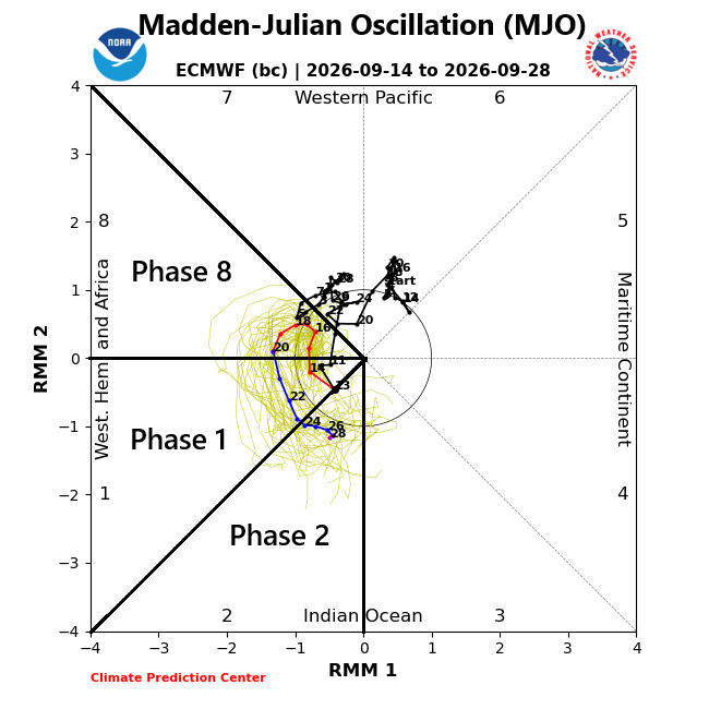
The teleconnection index known as the Madden-Julian Oscillation or MJO will “rotate” into phases known as 8, 1 and 2 in coming weeks according to a recent European model forecast. These locations are often correlated with increased tropical activity this time of year across the Atlantic Basin. Plot courtesy NOAA, ECMWF
Meteorologist Paul Dorian
Arcfield
arcfieldweather.com
Follow us on Facebook, Twitter, YouTube
Video discussion: