The collapse of El Nino in the tropical Pacific Ocean has begun and it will be rather dramatic. The current strong El Nino event reached its peak intensity level in December 2015 and all indications suggest it will completely flip to La Nina conditions by later this year. This naturally occurring oceanic cycle that produces warmer-than-normal sea surface temperatures (SSTs) in the equatorial region of the Pacific Ocean began in earnest early in 2015 and strengthened throughout the year to comparable intensity levels of the strong El Nino episodes of 1982-1983 and 1997-1998 although the warmest region relative-to-normal set up in somewhat different locations. El Nino has had widespread consequences around the world and will continue to do so in the near future. By later this year, colder-than-normal sea surface temperatures are quite likely to appear in the tropical Pacific Ocean as predicted by multiple computer forecast models and this flip to La Nina will also have extensive consequences around the world.
Read More
The current solar cycle, #24, is the weakest solar cycle in more than a century and it is now heading towards the next solar minimum phase which would be the beginning of solar cycle #25. The last solar minimum phase lasted from 2007 to 2009 and it was historically weak. In fact, it produced three of the most spotless days on the sun since the middle 1800’s (bar graph below). The current solar cycle is the 24th solar cycle since 1755 when extensive recording of solar sunspot activity began. Solar cycle 24 is currently on pace to be the weakest sunspot cycle with the fewest sunspots since cycle 14 peaked in February 1906. Solar cycle 24 continues a recent trend of weakening solar cycles which began with solar cycle 22 that peaked around 1990.
Read More
The “Blizzard of 2016” – some preliminary Mid-Atlantic snowfall reports (inches):
1) BWI Airport, MD - 29.2 (RECORD)
2) Philly Airport, PA - 22.4 (4th highest)
3) Dulles Airport, VA - 29.3 (2nd highest)
4) Central Park, NY - 26.8 (2nd highest)
5) Harrisburg, PA - 34.0 (RECORD)
6) Allentown, PA - 31.9 (RECORD)
7) JFK Airport, NY - 30.5 (RECORD)
8) LGA Airport, NY - 27.9 (RECORD)
9) King of Prussia, PA - 26.1
10) Chantilly, VA - 30.0
Reagan National Airport (DCA) in Washington, D.C. has officially come in with a highly suspicious reading of 17.8 inches and it is being investigated as it looks an underestimate compared to surrounding areas. This is not the first measurement problem at DCA. Last year, the temperature sensor at DCA was replaced as it was found to have been reporting erroneously high readings for years. By the way, 17.8 inches would make it the 4th biggest snowstorm ever at DCA.
Read More
One of the key factors cited in the Vencore Weather Winter Outlook (http://www.vencoreweather.com/2015-2016-winter-outlook) for a snowier-than-normal winter in the Mid-Atlantic region was the expectation for high-latitude blocking episodes this winter based on favorable signals from the Arctic Oscillation (AO) index, autumnal snowpack across Siberia, and on-going relatively quiet solar activity. In all likelihood, it appears we will have a stretch of at least two or three weeks with amazingly strong high-latitude blocking over places like Canada and Greenland which will increase chances for sustained cold air outbreaks into the Northeast US. A second important factor cited for more snow-than-normal this winter was the expectation that the strong El Nino phenomenon in the tropical Pacific Ocean would add moisture and energy to the southern branch of the jet stream. Indeed that appears ready to take place simultaneously with the high-latitude blocking as multiple storms are likely to trek from California to the Gulf of Mexico and then into the Northeast US during the next few weeks. All in all, it is looking very interesting and quite active for at least the next two or three weeks and accumulating snow is a good bet in the Mid-Atlantic region.
Read More
In all likelihood, El Nino in the tropical Pacific Ocean reached its peak intensity level several weeks ago and will completely flip to La Nina conditions later this year. This naturally occurring oceanic cycle that produces warmer-than-normal sea surface temperatures (SSTs) in the equatorial region of the Pacific Ocean began in earnest early last year and strengthened throughout 2015. It has become comparable in strength to the very strong El Nino events of 1997-1998 and 1982-1983 although the warmest region relative-to-normal has set up in a different location (current El Nino "centrally-based", 1997-1998 "eastern-based"). While the demise of this current El Nino event has likely begun - make no mistake about it - there will still be significant ramifications for the next few months in many places around the globe. By later this year, colder-than-normal sea surface temperatures are quite likely to appear in the tropical Pacific Ocean as suggested by numerous computer models and this flip to La Nina will also have widespread consequences.
Read More
We’ve talked for several days about several signals (“teleconnections”, stratospheric warming, MJO) that pointed to an important change coming in the overall weather pattern that would bring us much closer-to-normal temperatures by the beginning of the New Year and more sustained cold air outbreaks during the month of January and perhaps beyond. There is no change at all in that outlook. In fact, there are even signs for below-normal cold air outbreaks in the Mid-Atlantic region during the next few weeks beginning with an Arctic blast set to arrive for Monday and Tuesday of next week. Furthermore, now that the colder pattern seems to be settling into the Mid-Atlantic region, it is time to monitor potential threats for snow and indeed the period about 10-15 days from now looks quite ripe with storminess potential for the Mid-Atlantic region.
Read More
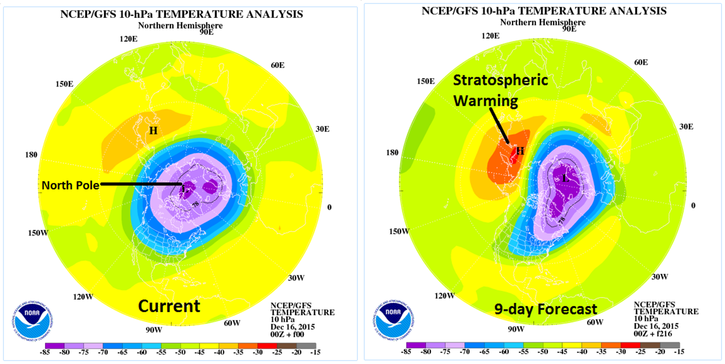
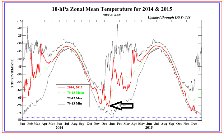
The month of December has been much warmer-than-normal in the Mid-Atlantic region (PHL +13.8°, DCA +11.3°,NYC +13.8°), but there are numerous signs that a significant pattern change is coming which will allow for much more in the way of sustained cold air outbreaks in the area. The first two signals suggesting a pattern change – stratospheric warming and a tropical disturbance known as the Madden Julian Oscillation (MJO) – have been discussed already in recent postings on our “Climate Info” page: http://www.vencoreweather.com/blog?category=Climate%20Info ). Now there are other “teleconnection” signals that also suggest a pattern change is coming to the Mid-Atlantic region for the month of January and perhaps even beyond which will bring far different weather than what we experienced during this potentially record-breaking warm month of December.
Read More
The month of December has been much warmer-than-normal in the Mid-Atlantic region and there are at least two more widespread record-breaking days to come in the near future. Longer term, however, there are signals for an important pattern change in the eastern states as we begin the New Year. One of the signals for a pattern change is connected to a tropical disturbance called the Madden Julian Oscillation (MJO). Its projected changes over the next couple of weeks as depicted by a reliable computer forecast model (Euro) suggest changes are coming here by the beginning of January.
Read More
The month of December has been much warmer-than-normal in the Mid-Atlantic region and there are several warm days still to come during this week and next. Indeed the month of December could turn out to be the warmest ever in much of the region aided in large part by the strong El Nino oceanic cycle in the tropical Pacific Ocean. So far this month temperatures have averaged 10.6°F above normal in Philadelphia, 11.3°F above normal in Central Park, NY, and 7.6°F above normal in Washington, D.C (Reagan National Airport). There are signs; however, for an important change in the overall weather pattern that is likely to occur around the New Year’s Day holiday period and it should bring quite a change in temperatures to the eastern states from well above normal to much closer-to-normal.
Read More