12:15 PM (Wed) | ***Western US storm to run into an “atmospheric roadblock” and be “forced” to slide southeast towards the Mid-Atlantic/NE US coastline…result will be snow and ice on Sunday/Monday***
Paul Dorian

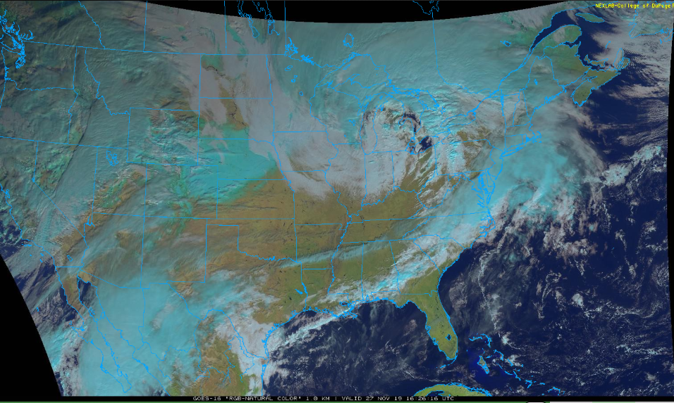
Two major storms continue to impact much of the nation on this the busiest travel day of the year; image courtesy College of DuPage, NOAA GOES
Overview
One strong storm is producing heavy snowfall across the Upper Midwest today and it’ll generate some very strong winds later today into Thursday in a large section of the country extending from the Great Lakes/Ohio Valley to the Mid-Atlantic/NE US. Another powerful storm continues to wreak havoc across much of the western third of the nation with heavy coastal rain and significant inland snows. This second system will push to the northeast over the next couple of days, but once it reaches the Dakotas, it’ll run into an “atmospheric roadblock” and be “forced” to slide southeast towards the Mid-Atlantic/NE US coastline by later this weekend into early next week. The result of this storm track will allow for cold air to be in place in the Mid-Atlantic/NE US when the storm arrives later this weekend and this raises the chance for snow and ice. The threat for snow and ice will continue into Monday for this part of the nation as the surface low spins around just off the coastline of the Mid-Atlantic/NE US.

NOAA’s “weather warnings” map is quite busy as a result of these two major storms; map courtesy NOAA
Initial storm
Heavy snow fell yesterday from the Colorado Rockies to the central Plains and now this storm is generating heavy snowfall in the Upper Midwest with more than a foot possible by day’s end in portions of Minnesota and Wisconsin. Yesterday’s snowfall in Colorado resulted in some “eye-popping” amounts with 19.8 inches recorded in Loveland – their biggest November snowfall ever – and an unofficial reading of 22.3 inches in Boulder which would be their biggest snowstorm ever. This system will move quickly over the next 12-24 hours reaching the coastal waters of Maine by tomorrow morning and its biggest impact will become the very strong wind gusts that it’ll generate from the Great Lakes/Ohio Valley to the Mid-Atlantic/NE US. High wind warnings have been issued in a widespread area from the Midwest to the interior Mid-Atlantic and these may be extended to the east coast by later today. Winds can gust to 50 mph in many of these areas over the next 24 hours or so

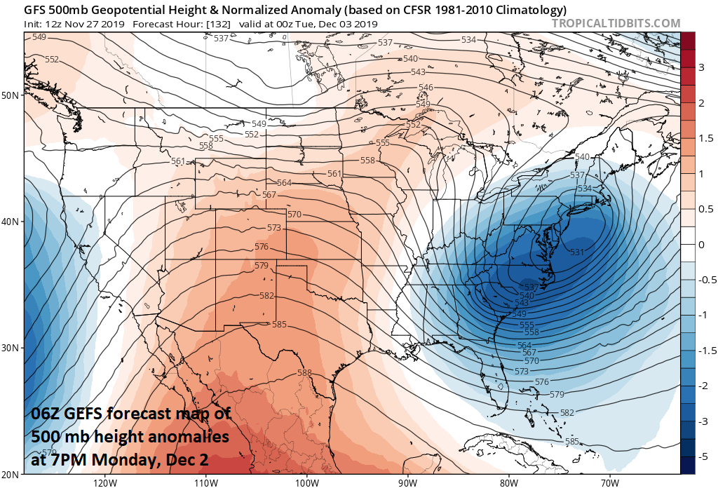
High-level high pressure ridging across south-central Canada will act as an “atmospheric roadblock” and force the western US storm to head towards the Mid-Atlantic/NE US coastline later this upcoming weekend; map courtesy NOAA, tropicaltidbits.com
Second storm
The major storm that made landfall near the Oregon/California border region last night has weakened some as it has moved inland. Heavy rains continue across coastal sections and heavy snowfall is taking place in higher elevation inland locations. The Sierra Nevada mountain range in eastern California may see some spots measuring 3 to 4 feet of snow by the time this system pulls away and turns northeastward towards the Northern Plains. The lowest pressure observed with this major storm appears to be 28.69 inches in Crescent City, CA which is unofficially the lowest pressure ever recorded in the state.
A strong storm is likely to “spin around” just off the Mid-Atlantic/NE US coastline as we begin the new work week; map courtesy NOAA, tropicaltidbits.com
Once the storm reaches the Northern Plains, it’ll run into an “atmospheric roadblock” as strong high pressure ridging aloft over south-central Canada will prevent any further movement to the northeast. Instead, this system will be “forced” to make a southeast turn and ultimately, will likely end up near or just off the Mid-Atlantic/NE US coastline by late in the weekend. This kind of storm track will allow for a cold air mass to dive to the south this weekend from southeastern Canada into the Mid-Atlantic/NE US and this raises the chance for snow and/or ice in many spots once the precipitation arrives late Saturday night/early Sunday. A changeover to plain rain is possible on Sunday; especially, in areas close to the coast such as the urban areas along I-95. However, once this system reaches the waters just off the Mid-Atlantic/NE US coastline early next week, it may “spin around” for awhile and this raises the chance that some areas will see the precipitation change back to snow and/or ice on Monday…perhaps with decent accumulations.
Stay tuned…it’ll be an interesting transition from November to December for much of the nation.
Meteorologist Paul Dorian
Perspecta, Inc.
perspectaweather.com
Video: