9:45 AM (Tuesday) | *Hurricane “Delta” now a category 2 storm is on its way to “major” hurricane status…"Delta" is headed for Mexico’s Yucatan Peninsula and then likely the north-central Gulf coast*
Paul Dorian

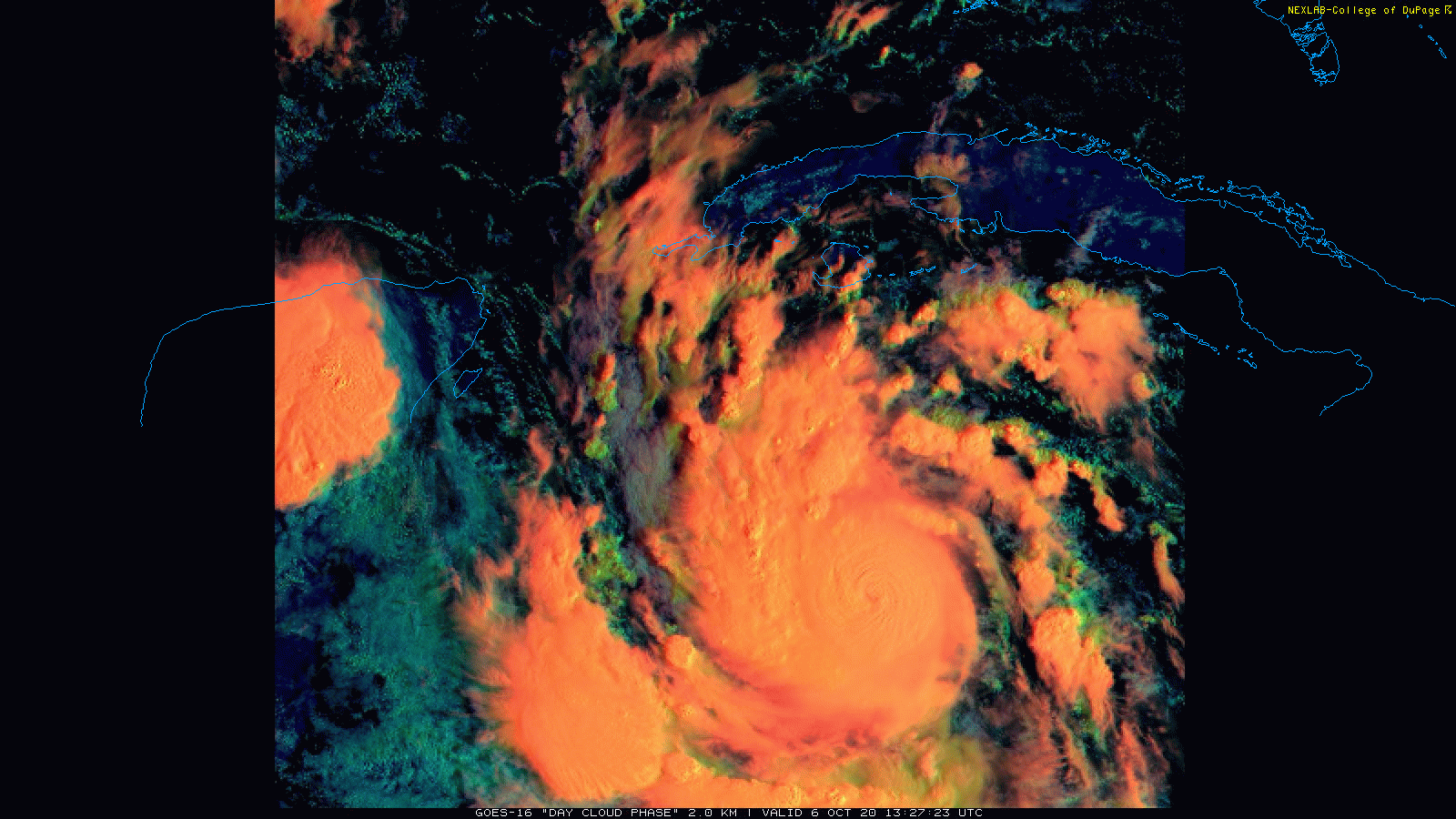
Hurricane “Delta” is now a category 2 storm on its way to “major” status with an eye trying to form as it churns to the WNW at 15 mph. Hurricane “Delta” could reach category 4 status by later today and has an outside shot at attaining category 5 status within the next 24 hours or so. Satellite images courtesy College, of DuPage, NOAA
Overview
All systems are go for Hurricane “Delta” as it has undergone rapid intensification in the last 24 hours and will very likely reach at least category 4 “major” hurricane status over the next 12-24 hours. During the past 24 hours, Hurricane “Delta” has seen its maximum sustained winds increase by 70 mph – now at 110 mph – which represents the fastest October intensification of a tropical cyclone since “Wilma” of 2005. Hurricane “Delta” is headed towards the northeast part of the Yucatan Peninsula region of Mexico in coming days – very likely as a category 4+ storm. After that, “Delta” may make a direct impact on the north-central Gulf coastal region (e.g., southern Louisiana) by late Friday or so and then take a turn to the north and east once inland with significant rainfall in the Deep South and Tennessee Valley – perhaps even bringing some late weekend rainfall to the Mid-Atlantic region.

NOAA’s National Hurricane Center’s forecast track of Hurricane “Delta” has it reaching the northern Gulf coastal region by Friday night or early Saturday. Map courtesy NOAA/NHC
Details
The sea surface temperatures in the Caribbean Sea are still very warm, moisture levels are high, and the vertical wind shear has been virtually non-existent in the last 24 hours or so and these favorable conditions have allowed for a rapid intensification of Hurricane “Delta” – now a strong cat 2 storm – and the strengthening is not near over. In fact, Hurricane “Delta” is very likely to reach “major” hurricane status (i.e., category 3 or higher) in the near-term as it heads towards the northeast part of Mexico’s Yucatan Peninsula and there is even an outside chance of an intensification all the way to category 5 status (i.e., max sustained winds of over 155 mph) in the next day or so. In the past 24 hours, maximum sustained winds of Hurricane “Delta” have increased by 70 mph and the central pressure has dropped by 42 millibars. This type of rapid intensification has not been seen in an October tropical system since Hurricane “Wilma” did so in the super-charged year of 2005.

Significant rainfall associated with the remnants of Hurricane “Delta” could extend from the south-central states to the Mid-Atlantic region after possible landfall in southern Louisiana. Map courtesy NOAA/WPC
After an encounter with the Yucatan Peninsula, Hurricane “Delta” is unfortunately, quite likely to maintain most of its strength and spill out over the still very warm waters of the southern Gulf of Mexico. Looking beyond, Hurricane “Delta” appears to be headed on a collision course with the north-central Gulf coastal region by late Friday or early Saturday - perhaps not all that far from where Hurricane Laura hit earlier this tropical season in the southwestern part of Louisiana. Hopefully, there will be some weakening of Hurricane “Delta” as it approaches the north-central Gulf coastal region late Friday and this is a decent possibility as it will encounter somewhat cooler-than-normal sea surface temperatures in those last hours before landfall. [The cooler-than-normal waters in the northern Gulf of Mexico are actually a leftover effect of Hurricane “Sally” through the process of upwelling].

Warmer-than-normal waters in the western Caribbean Sea (boxed region) aiding in the rapid intensification of Hurricane “Delta”. Cooler-than-normal waters in the northern Gulf of Mexico (shown in blue) provides some hope for a weakening of “Delta” as it approaches the north-central Gulf coastal region later in the week. Map courtesy NOAA, tropicaltidbits.com
Once “Delta” goes inland, it is likely to turn to the north and east and spread some significant rainfall to the Deep South and the Tennessee Valley. In fact, some the heavy rainfall associated with the remnants of Hurricane “Delta” could make it all the way into the Mid-Atlantic region by the late stages of the upcoming weekend. On a positive note, there is a chance that the Atlantic Basin turns quiet again in terms of tropical activity after the Yucatan region of Mexico and the southern/eastern US deal with the effects of powerful Hurricane “Delta”.
Meteorologist Paul Dorian
Perspecta, Inc.
perspectaweather.com
Follow us on Facebook, Twitter, YouTube
Video discussion: