
10:30 AM (Saturday) | ***Major storm to impact much of the nation from Sunday into Monday with accumulating snow, heavy rain, damaging winds and severe thunderstorms...cold blast to follow***
Paul Dorian

The major storm will head from the Plains on Sunday to the Great Lakes on Monday morning and it will intensify rapidly along the way. Heavy snow (shown in blue) will take place to the storm’s north and west and heavy rain and severe weather is likely to its south and east. Map courtesy NOAA, tropicaltidbits.com
Overview
A major storm will impact a large part of the nation from tomorrow into Monday with a wide-ranging set of conditions from accumulating snows in its cold sector to heavy rain and severe weather in areas to the east and south of the storm track. Low pressure will consolidate over the Mississippi Valley on Sunday morning and then intensify significantly as it pushes northeastward into the Great Lakes region by Monday morning. Accumulating snows are likely from this storm from the Rockies to the Upper Peninsula of Michigan where a foot or more can fall. The threat for severe weather will be widespread from Sunday into Sunday night in the region extending from Texas/Louisiana to the Carolinas as ingredients come together to destabilize the atmosphere. A significant rain and extreme wind event is coming to the Mid-Atlantic region from Sunday night into Monday and it can include damaging wind gusts of up to 60 mph and perhaps severe thunderstorm activity. All of this will be followed by a cold blast of air for mid-April that will arrive in the eastern US on Tuesday and another low pressure system could even produce some in parts of the Mid-Atlantic by Tuesday night and Wednesday.

A widespread severe weather outbreak is possible from Sunday into Sunday night; primarily, focused on the southern US. Map courtesy NOAA/SPC
Details
Low pressure will come together on Sunday across the central Plains as the system that was swirling over California for a few days earlier this week finally ejects eastward into the middle of the country. This system will have several ingredients that will promote rapid intensification between Sunday morning and mid-day Monday including a surge of very warm and humid air on its southeast side, an influx of abnormally cold air to its north and west, and vigorous energy aloft that will ultimately take on a “negative-tilt” enhancing upward motion.
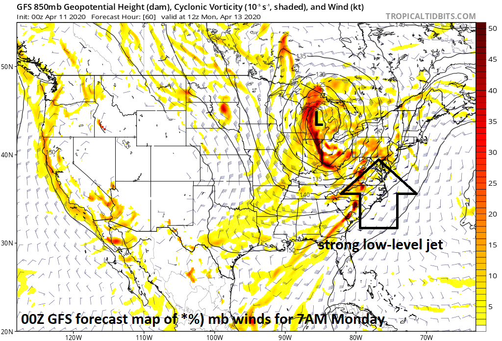
The major storm will feature strong winds on its east and south in the lower levels of the atmosphere which can result in damaging winds gusts and perhaps tornadic activity; Map courtesy NOAA, tropicaltidbits.com
An outbreak of severe thunderstorms appears quite likely on Sunday from Texas to the Carolinas with the greatest threat extending from Louisiana, Mississippi and Alabama to the Tennessee Valley. Given the likelihood of very strong winds in the lower and middle atmosphere, damaging wind gusts are a main severe weather threat and tornadoes are quite possible as well in much of this region. By Sunday night, the severe weather threat can extend northeastward into the Ohio Valley with the chance there of damaging wind gusts and even some tornadic activity.
In the Mid-Atlantic region, rain is likely to arrive on Sunday night and become heavy at times by early Monday morning and 2+ inches is on the table during this event. Warmer and humid air will surge northward on Monday along the eastern seaboard and temperatures could shoot up into the 70’s in the DC, Philly, NYC corridor to go along with the rain and strong winds. Given the expectation of strong winds in the lower and middle levels of the atmosphere of up to 80 mph or so, it wouldn’t take much to see some damaging wind gusts of up to 60 mph in the Mid-Atlantic region anytime from late Sunday night into late Monday.

Widespread below-normal temperatures will follow the major storm in the eastern two-thirds of the nation. Map courtesy NOAA, tropicaltidbits.com
In addition, severe thunderstorms are a possibility depending on the timing of the cold front that will be barreling towards the east coast from the Ohio Valley. If the arrival of the front holds off until late in the day and there is any kind of mid-day “break in the action” allowing for some sunshine then the chances for strong-to-severe thunderstorms will increase. A “break in the action” in the precipitation is indeed on the table on Monday as there can be a “dry slot” that forms as the precipitation field may turn out to be multiple narrow bands of showers and thunderstorms with rain-free conditions in between.

The major storm will produce accumulating snow from the Rockies to the western Great Lakes. Map courtesy NOAA, tropicaltidbits.com
The deep low pressure system pulls away on Tuesday and a colder-than-normal air mass slides into the Mid-Atlantic region. The trailing cold front may get hung up near the east coast on Tuesday allowing for the possibility of another low pressure system to form along the frontal boundary zone. If this were to take place, precipitation could re-develop from Tuesday night into Wednesday in the Mid-Atlantic region and it could actually be cold enough for some wet snowflakes in some higher elevations locations. The colder-than-normal weather pattern will on average stick around in the central and eastern US for much of the second half of the month of April.
Meteorologist Paul Dorian
Perspecta, Inc.
perspectaweather.com
Follow us on Facebook, Twitter, YouTube