
10:20 AM (Sunday) | ***Major storm to impact much of the nation from today through Monday with accumulating snow, heavy rain, damaging wind gusts and severe weather…cold blast to follow***
Paul Dorian
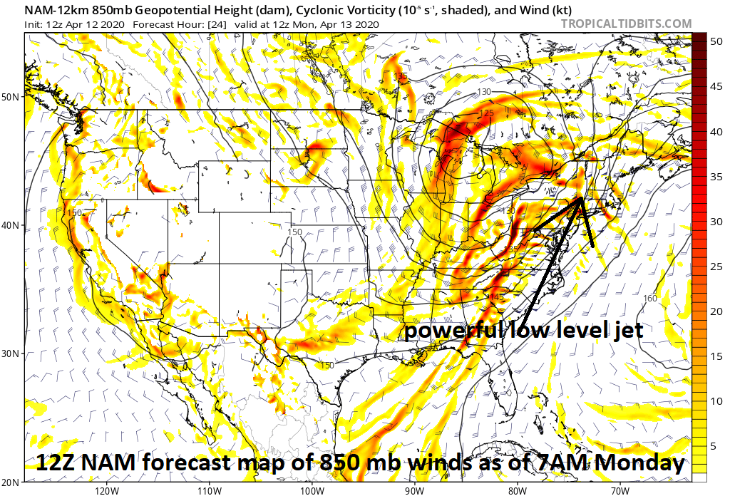
One of the key ingredients leading to the likelihood of damaging wind gusts with this major storm system will be a very strong low level jet of up to 80 mph or so on its eastern flank. Winds could gust past 60 mph on Monday in the Mid-Atlantic region whether or not severe thunderstorms actually do form and widespread power outages are a real concern. Map courtesy NOAA, tropicaltidbits.com
Overview
A major storm will impact a large part of the nation from today into Monday with a wide-ranging set of conditions from accumulating snows in its cold sector to heavy rain and severe weather in areas to the east and south of the storm track. Low pressure will consolidate over the central Plains today and then intensify significantly as it pushes northeastward through the Great Lakes region early Monday and then to the Hudson Bay, Canada region by Monday night. Accumulating snows are likely from this storm from the Rockies to the Upper Peninsula of Michigan where a foot or more can fall. The threat for severe weather will be widespread from today into tonight in the region extending from Texas/Louisiana to the Carolinas and as far north as the Ohio Valley as ingredients come together to destabilize the atmosphere. A significant rain and extreme wind event is coming to the Mid-Atlantic region on Monday with heavy rain, damaging wind gusts of 60+ mph, and perhaps severe thunderstorm activity with hail and isolated tornadoes. All of this will be followed by a cold blast of air for mid-April that will arrive in the eastern US on Tuesday and a weaker low pressure system could produce more precipitation from Tuesday night into Wednesday - and it could even be cold enough for wet snow in some areas.

The developing major storm system will be situated over the Great Lakes region by Monday morning and still undergoing significant intensification. Map courtesy NOAA, tropicaltidbits.com
Details
Low pressure will come together today across the central Plains as the system that was swirling over California earlier this week finally has pushed into the middle of the country. This system will have several ingredients that will promote rapid intensification between this morning and late Monday including a surge of very warm and humid air on its southeast side, an influx of abnormally cold air to its north and west, and vigorous energy aloft that will ultimately take on a “negative-tilt” enhancing upward motion.

Severe weather will be quite significant on the south and east side of this developing major storm system (i.e., in the warm sector) over the next 24-36 hours extending from the southern US to the Mid-Atlantic region. Map courtesy NOAA, tropicalttidbits.com
An outbreak of severe thunderstorms appears quite likely today from Texas to the Carolinas with the greatest threat extending from Louisiana, Mississippi, Alabama and Georgia on the southern side to the Tennessee Valley in the north. Given the likelihood of very strong winds in the lower and middle atmosphere, damaging wind gusts are a main severe weather threat and tornadoes are quite possible as well in some of this region. By Sunday night, the severe weather threat can extend northeastward into the Ohio Valley with the chance there of damaging wind gusts and even some tornadic activity.

Accumulating snow will be quite significant on the north and west side of this developing major storm system (i.e., in the cold sector) over the next 24-36 hours extending from the Rockies to southern Canada. Map courtesy NOAA, tropicalttidbits.com
In the Mid-Atlantic region, rain is likely to arrive late Sunday night and become heavy at times by early Monday and 2+ inches is on the table during this event. Warmer and humid air will surge northward on Monday along the eastern seaboard and temperatures could shoot up into the 70’s in the DC, Philly, NYC corridor to go along with the rain and strong winds. Given the expectation of extremely strong winds in the lower levels of the atmosphere of up to 80 mph or so, it wouldn’t take much to see some damaging wind gusts of 60+ mph in the Mid-Atlantic region anytime on Monday - and this could happen regardless of whether severe thunderstorms actually do form. Watch out for downed tree limbs on Monday and unfortunately, there is the good chance for numerous power outages.

The developing major storm system has prompted all kinds of “weather warnings” by NOAA across much of the nation.
In addition, severe thunderstorms are a possibility depending on the timing of the cold front that will be barreling towards the east coast from the Ohio Valley. If the arrival of the front holds off until late in the day and there is any kind of mid-day “break in the action” allowing for some sunshine then the chances for strong-to-severe thunderstorms will increase. A “break in the action” in the precipitation is indeed on the table on Monday as there can be a “dry slot” that forms as the precipitation field may turn out to be multiple narrow bands of showers and thunderstorms with rain-free conditions in between. Any severe thunderstorm can include hail and even isolated tornadoes in addition to heavy rain and strong wind gusts.

A cold blast will follow the major storm system with widespread below-normal temperatures by mid-week across much of the eastern two-thirds of the nation. Map courtesy NOAA, tropicalttidbits.com
The deep low pressure system pulls away on Tuesday and a colder-than-normal air mass slides into the Mid-Atlantic region. The trailing cold front may get hung up near the east coast on Tuesday allowing for the possibility of another (weaker) low pressure system to form along the frontal boundary zone. If this were to take place, precipitation could re-develop from late Tuesday night into Wednesday in the Mid-Atlantic region and it could actually be cold enough for some wet snow in parts of the Mid-Atlantic region. This time of year the best chance for snow would be in the higher elevations locations to the north and west of Route I-95. The colder-than-normal weather pattern will stick around in the central and eastern US for much of the second half of the month of April.
Buckle up…its going to be a wild ride.
Meteorologist Paul Dorian
Perspecta, Inc.
perspectaweather.com
Follow us on Facebook, Twitter, YouTube