2:00 PM (Thurs.) | *Strong thunderstorm threat continues in the Mid-Atlantic…an active tropical scene with two systems to monitor…Comet NEOWISE makes is closest approach to Earth*
Paul Dorian

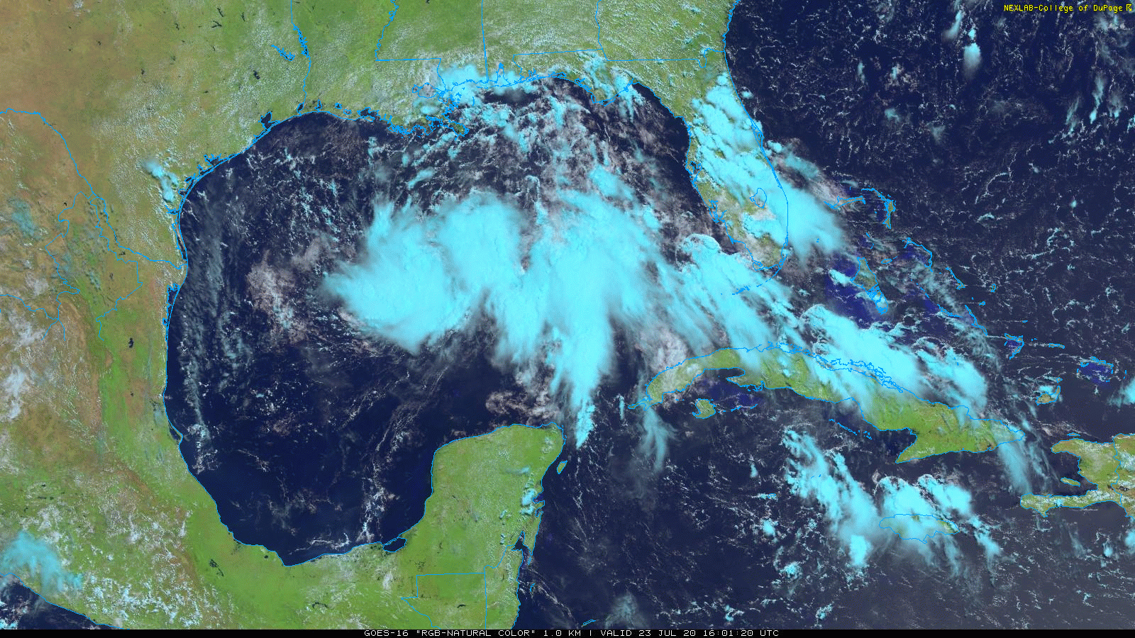
Tropical Depression #8 continues to churn slowly over the Gulf of Mexico in a general WNW direction. This system could reach tropical storm strength before it reaches the east coast of Texas likely on Saturday where very heavy rainfall is on the table. Imagery courtesy College of DuPage, NOAA
Overview
A potpourri of topics today ranging from another day with a strong thunderstorm threat in the Mid-Atlantic region to an active Atlantic Basin tropical scene to an update on Comet NEOWISE which is making its closest approach to Earth later tonight. First, on the weather threat in the Mid-Atlantic region, yet another wave of energy aloft will combine with considerable amounts of moisture in the low and middle levels of the atmosphere to bring another shot at strong storms later today and tonight. Second, on the tropics, an impressive tropical wave over the central Gulf of Mexico is likely headed to the east coast of Texas by the early part of the weekend and it will result in heavy rainfall in that part of the southern US. A second tropical system, Tropical Storm Gonzalo, has run into a bit of dry air which has halted its intensification in recent hours as it continues to push towards the Caribbean Sea. A third tropical wave has just emerged off the west coast of Africa and it may become an important player to monitor next week. Finally, Comet NEOWISE makes its closest approach to the Earth later tonight and it won’t be back around these parts for about 6800 years.
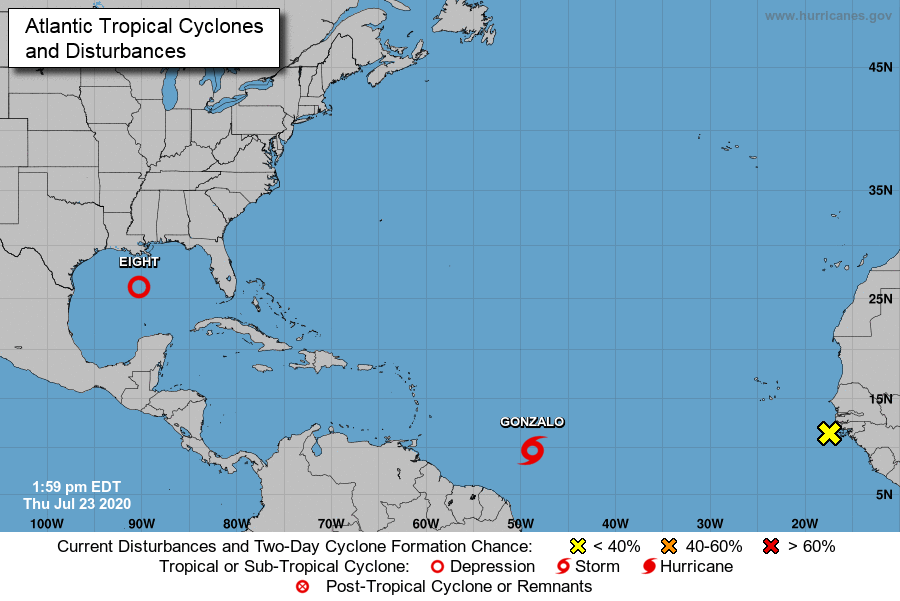
Two systems are being closely monitored in the Atlantic Basin….TD #8 (Gulf of Mexico) and TS Gonzalo (central Atlantic). There is also a third system just now coming off the west coast of Africa (“X” at far right) and it could actually become more important of a system than Gonzalo which is likely to weaken in coming days. Map courtesy NOAA/NHC
An active Atlantic Basin tropical scene
There are two tropical systems that we continue to closely monitor. The first system is Tropical Depression #8 and it is pretty impressive-looking on satellite imagery and has a decent chance at becoming a named tropical storm (would be “Hannah”). The latest measurements for this system have its movement at only 7 mph in a WNW direction with maximum sustained winds at 35 mph. This tropical system will continue to drift west-to-northwest over the next day or so and likely make landfall somewhere along the east coast of Texas on Saturday – perhaps as a named tropical storm. Whether or not it reaches tropical storm status, it appears as though this system will produce a lot of heavy rainfall for Texas and perhaps parts of Louisiana; especially, given its rather slow movement.
Meanwhile, a second tropical system over the central Atlantic, Tropical Storm Gonzalo, has stayed relatively steady in recent hours in terms of intensity. Its latest measurements show a westerly movement at 14 mph with maximum sustained winds at 60 mph. The storm’s center has become a little bit more disorganized compared to yesterday as it has encountered some dry air in mid-levels of the atmosphere. Tropical Storm Gonzalo appears headed for the lower part of the Caribbean Sea over the next couple of days and it is somewhat unclear as to its prospects for additional intensification. It wouldn’t take much for Gonzalo to intensify into a category 1 hurricane over the next 12-24 hours, but its longer-term prospects for development are questionable at best. Small tropical cyclones like Gonzalo tend to succumb rather easily to any kind of unfavorable atmospheric conditions and it looks like the environment once over the Caribbean Sea will not be all that favorable for intensification. Tropical Storm Gonzalo is the 7th named system in this still rather young Atlantic Basin tropical season. A third tropical system has just emerged off the west coast of Africa and it will probably be another one to closely monitor by the early part of next week.

Storms are firing up across upstate PA and in the Ohio Valley and some of these cells will work their way into the I-95 corridor later in the afternoon and tonight. NEXRAD map courtesy NOAA, University of Wisconsin
Strong thunderstorm threat for the I-95 corridor
After a mainly cloudy morning, sunshine has returned to the Mid-Atlantic region and mid-day and early afternoon heating in the low levels of the atmosphere is going to “fuel up” the atmosphere for late day and nighttime showers and thunderstorms. The low-level heating will combine with the abundance of available moisture and an in-coming frontal system to destabilize the atmosphere later today and tonight. Some of the late day and nighttime thunderstorms can be strong with gusty winds and heavy downpours, but they are likely to be somewhat more scattered compared to the widespread activity that we experienced late yesterday. Nonetheless, new storms are firing up in upstate Pennsylvania and numerous storms are pushing eastward across the eastern Ohio Valley. Following the passage of the frontal system on Friday, slightly drier air will become more noticeable by tomorrow night and during the early part of the weekend, but it should still turn out to be rather warm on Saturday afternoon and then turn even warmer early next week with the return of higher humidity. One final note, today’s strong thunderstorm threat will not be limited to the Mid-Atlantic region. In fact, strong-to-severe thunderstorms are quite likely later today and tonight across the entire Northeast US where a vigorous wave of energy will pass overhead.

Astrophysicist Gianluca Masi of the Virtual Telescope Project captured this view of Comet C/2020 F3 (NEOWISE) on July 18, 2020. (Image credit: Gianluca Masi/The Virtual Telescope Project, space.com)
Comet NEOWISE
Tonight could be the best chance to see Comet NEOWISE for another 6800 years (weather permitting of course). At approximately 9:09 PM (ET), Comet NEOWISE will reach perigee or its closest distance to Earth at about 64.3 million miles. In truth, the comet has dimmed some in recent days and is generally visible to the naked eye from dark sites only with the best of atmospheric conditions (i.e., low humidity, no clouds). However, it can still be found rather easily with binoculars for another several days - if overall sky conditions are favorable.

Comet NEOWISE will still be visible for another several days including shortly after sunset tonight in the NNW sky - weather permitting. Sky map courtesy spaceweather.com
This comet has certainly not been a disappointment for skywatchers in terms of terms of overall viewing - unlike two comets earlier in the year, ATLAS and SWAN, which disintegrated upon their approach to the sun. Comet NEOWISE won’t be back this way for another 6800 years because of its extremely long, elliptical orbit.
Meteorologist Paul Dorian
Perspecta, Inc.
perspectaweather.com
Follow us on Facebook, Twitter, YouTube
Video discussion: