
****Significant storm threat for the eastern US for Sunday/Monday…snow, ice, rain, coastal flooding, damaging winds are all on the table…front-end accumulating snow/ice for I-95****
Paul Dorian
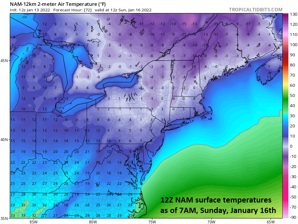
Very impressive cold expected early on Sunday in the Mid-Atlantic region…paves the way for a period of snow/ice at the front-end of the upcoming storm. Map courtesy NOAA, tropicaltidbits.com
Overview
Many ingredients are coming together for a high impact type of storm system in the eastern third of the nation from Sunday into Monday with accumulating snow, ice, heavy rain, coastal flooding, and even high (potentially damaging) winds all on the table. The upper-level wave of energy that will be the catalyst for storm development is just now coming ashore in the Pacific Northwest and it will dive to the south and east over the next few days. Low pressure will develop by early Sunday morning in the southeastern states and this system will then make a move to the northeast and it’ll encounter an Arctic air mass that will be quite reluctant to give up its ground. As a result, a significant snow and ice event is likely to take place across interior sections of Georgia and the Carolinas on Sunday morning and mid-day. After that, precipitation will push into the Mid-Atlantic region with cold, dense air in place and a period of snow and/or ice is likely in most interior sections with rain a likelihood along coastal areas. The DC-to-Philly-to-NYC corridor is in line for accumulating snow on the front-end of this storm and this can be followed by a period of icing given the expectation that the dense, cold low-level air mass will be tough to dislodge.

Powerful low-level jet expected to form during this event leading to some high and potentially damaging winds; especially, along coastal sections of NJ and the Delmarva. Map courtesy NOAA, tropicaltidbits.com
Details
Numerous ingredients are going to come together this weekend for the development of a powerful storm system that will have a high impact on the eastern third of the nation. The first ingredient is a vigorous upper-level disturbance that is currently located near the Pacific Northwest coastline. This upper-level system will drop southeastward over the next couple of days and it’ll phase together with a disturbance riding along in the northern branch of the jet stream to form a potent upper-level low over the south-central states by Saturday afternoon. At the same time, cold, dense Arctic air will become well established across the Mid-Atlantic States and Northeast US thanks to strong high pressure that will build into the southeastern part of Canada. Two other factors that will play crucial roles in this unfolding storm system will include a powerful jet streak that will form in the lower part of the atmosphere and there will be an influx of tropical air on the warm side of the storm containing very high moisture content.

An influx of very moist tropical air will play an important role in this upcoming event. As this moist air rides up and over the cold, dense air up north, significant snow can break out in the storm’s cold sector (NW side). Map courtesy NOAA, tropicaltidbits.com
By early Sunday, the potent upper-level system will reach the Deep South and surface low pressure will begin to take shape at the same time the Arctic high to the north moves to a position over New England. Cold, dense low-level air will pour down the east side of the Appalachians (cold air damming) setting the stage for lots of frozen precipitation on Sunday in the interior sections of Georgia and the Carolinas as the surface low begins its push to the northeast. In fact, the stage may be setting up in this region for a significant and dangerous snow and ice event on Sunday.

The GFS “ensembles” still favor a slightly farther south and east storm track compared to the “operational” run of the model. This is the latest snowfall map from the “ensemble” version of the GFS for the upcoming storm. Map courtesy NOAA, Weather Bell Analytics
By late Sunday, moisture from the storm will arrive in the Mid-Atlantic region and encounter cold, dense air in the lower levels of the atmosphere. As such, snow is likely to break out in the DC-to-Philly-to-NYC late Sunday or early Sunday night and front-end accumulations are quite likely with the higher amounts to the north and west of the big cities. After that, if the storm track ends up slightly inland near or over Route I-95 then slightly milder air would push in from the ocean. This would likely result in a changeover of the snow to sleet and/or freezing rain in the I-95 corridor for a period of time with a struggle to get above freezing; especially, in the northern and western suburbs. Heavy snow would be likely fall well to the west and north of I-95 and plain rain to the south and east. In fact, coastal sections of New Jersey and the Delmarva Peninsula may be in for some heavy rainfall, coastal flooding, and perhaps even some very high (onshore) winds given the expectation of a powerful low-level jet. A slightly inland storm track would result in the heaviest snowfall being across West Virginia, western Virginia, western and central PA, and western and central NY. In those areas where a mixture does take place, the precipitation can actually change back to all snow on the back-end of the storm as colder air wraps back around - perhaps in the early morning hours on Monday.
If the storm track ends up a little farther to the south and east as is currently projected then there can be a more prolonged period of accumulating snow and ice in the immediate I-95 corridor. In my opinion, this outcome is still a realistic possibility as a more “natural” path for the surface low pressure system would be along areas of temperature gradients. Indeed, this time of year the east coast is an area usually with a sharp temperature contrast as the result of the relatively warm waters of the western Atlantic Ocean to the east and the cold land mass to the west. In fact, this kind of a “coastal” storm track is actually being hinted at by some of the “ensemble” runs of the computer forecast models (watch the “Ensemble Forecasting” video found on the “Meteorology 101” page of arcfieldweather.com for a discussion on this type of forecasting). There are still many details that will have to wait a bit longer to get ironed out given the event time is still a few days away.
One final note, the overall weather pattern looks to remain quite a bit colder-than-normal in the central and eastern US as we go through the second half of January - perhaps to include some extreme cold during the week of the 23rd.
Meteorologist Paul Dorian
Arcfield
arcfieldweather.com
Follow us on Facebook, Twitter, YouTube
Video discussion: