*****Major winter storm this weekend to impact a large part of the nation...a crippling ice event in some areas...a significant snowfall in other areas including the Mid-Atlantic region*****
Paul Dorian

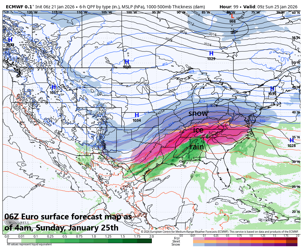
A major winter storm will have big-time impacts this weekend across a large part of the nation to include significant icing in some areas (sleet shown in orange, freezing rain in pink) and substantial snow in others (snow shown in blue). Map courtesy ECMWF, Weather Bell
Overview
The next in a series of Arctic air outbreaks will plunge into the north-central states on Thursday and it’ll swallow up much of the eastern two-thirds of the nation by the upcoming weekend. This next Arctic outbreak will be the real deal featuring some extremely cold air, and it’ll set the stage for widespread impacts this weekend by a major storm system. A crippling ice event is on the table for many in the Texas-to-Virginia corridor, and a significant snowfall in other areas including the Mid-Atlantic region. Following the storm, brutal cold is likely across much of the nation including in the Mid-Atlantic region where morning lows may be pretty amazing indeed during the first half of next week.
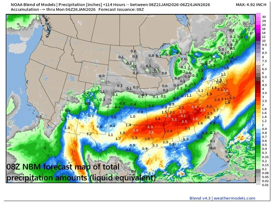
This forecast map by a blend of models of total precipitation amounts (liquid equivalent) for the weekend event is alarming in that much of this moisture will be in areas where Arctic air becomes fully entrenched…the result likely to be a crippling icing event for some and a significant snowfall for others. Map courtesy NOAA, weathermodels.com (Ryan Maue, X)
Details
It’ll actually turn noticeably milder on Thursday in the Mid-Atlantic region with temperatures likely to reach the 50-degree mark in some spots along the I-95 corridor; however, a look at the temperature pattern upstream will raise a red flag that this warmup in the local area will be just a temporary blip. Indeed, the next in a series of Arctic air outbreaks will be invading the north-central states on Thursday and it’ll swallow up much of the eastern two-thirds of the nation by the upcoming weekend. This next Arctic blast will mean business with temperatures dropping to as low as 30 degrees below zero across parts of the Northern Plains – far below-normal in what is climatologically-speaking, the coldest time of the year.
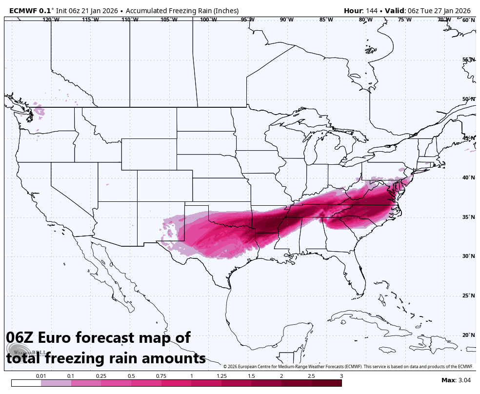
Unfortunately, the weekend storm system is liable to generate significant icing in some areas across the Texas-to-Virginia corridor. The biggest concern for this threat may be in the Arkansas-Tennessee-North Carolina area where ice buildup could become quite large and damaging in nature. Map courtesy ECMWF, Weather Bell
On Friday, copious amounts of moisture will start gathering across the south-central states. As this moisture shield then heads to the north and east, it will encounter a very cold air mass with origins way up in the Arctic. As such, frozen precipitation will break out with significant icing across many southern states this weekend all the way from Texas-to-Virginia....the most worrisome areas may be Arkansas, Tennessee, and North Carolina where the ice buildup could become quite large and damaging in nature.
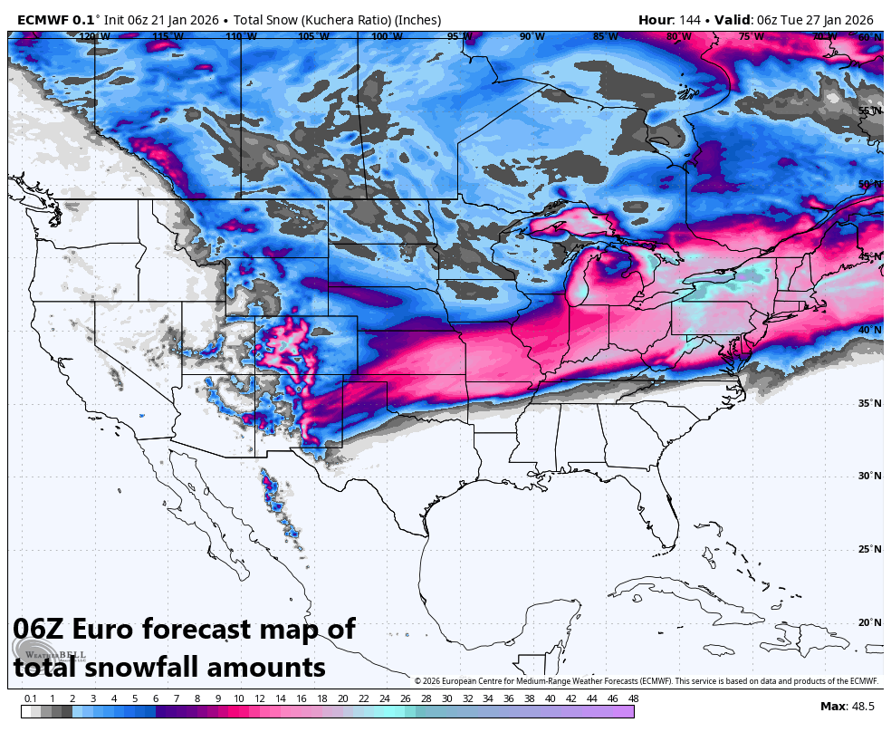
A swath of significant snowfall is in the offing during the upcoming weekend event all the way from the south-central states to the Mid-Atlantic/Northeast US. Map courtesy ECMWF, Weather Bell
As the moisture pushes farther to the north and east, snow will break out, and significant accumulations are on the table all the way from the Central Plains to the Mid-Atlantic/Northeast US. A difficulty in the forecast with respect to total snow accumulations for the immediate DC-to-Philly-to-NYC corridor is that sleet can certainly mix into the picture - perhaps even some freezing rain - during the weekend storm and this would have an impact on final amounts. Despite some very cold surface-level air during the weekend, some slight warming can take place aloft as the initial (primary) surface low heads towards Kentucky/West Virginia before a transfer of energy spawns a secondary low pressure just off the Mid-Atlantic coastline (a “Miller B” type of storm track). As the initial low reaches its most northward extent, so will the slight warming aloft, and then as the secondary low takes full control just off the east coast, colder air aloft will tend to push back down to the south and east.
This next in a series of Arctic outbreaks for the US will mean business…temperatures could drop to as low as 30 degrees below zero in the Northern Plains and it’ll be very cold during the storm across a wide section of the country. Maps courtesy NOAA, Ryan Maue (X)
Despite the threat of some icing, this could turn out to be the biggest snowstorm in a decade for the DC-to-Philly-to-NYC corridor with a foot or more on the table. The timeframe in the Mid-Atlantic’s I-95 corridor appears to from later Saturday night into later Sunday night meaning there can be impacts on travel conditions to start the new work week. Bitter cold air will follow the storm with some rarely-seen low temperatures possible in the Mid-Atlantic region during the first half of next week. The last time Philly and DC recorded temperatures below zero was January 1994…just saying. And a quick look ahead, there can be another major storm system to deal with along the east coast about a week after this weekend’s event (i.e., somewhere around 1/31-2/1)...more on that threat next week.
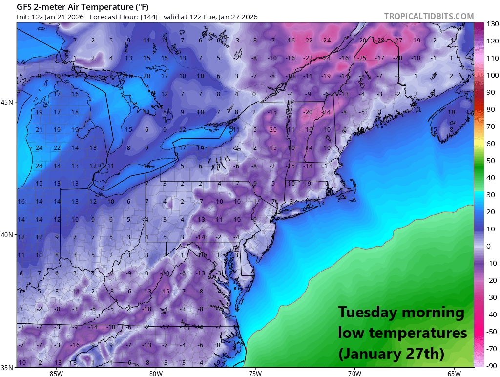
Bitter cold air will push into the Mid-Atlantic region this weekend and stick around through the storm. On the heels of the storm, it’ll remain brutally cold early next week and low temperatures on Tuesday morning could be in seldom seen territory around here. Map courtesy NOAA, tropicaltidbits.com
There are still a few days to go before this weekend’s event and there will likely be some adjustments; however, from this vantage point, all signs continue to point to a major winter storm that will have big-time impacts across a large portion of the nation…this would include a crippling ice event in some areas, and a significant snowfall in other areas including the Mid-Atlantic region.
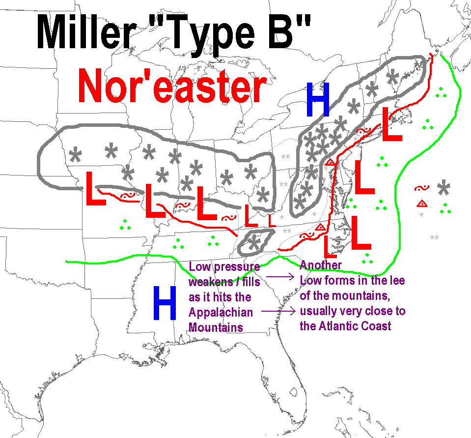
The weekend storm system will likely take the “Miller B” type of track for a nor’easter with an initial (primary) low heading to Kentucky/West Virginia and then a secondary low will form just off the Mid-Atlantic coastline and it’ll become the main player. An alternative track known as a “Miller A” is when a low pressure system rides ride up along or near the eastern seaboard…a threat for that kind of scenario may come in the 1/31-2/1 time frame.
Meteorologist Paul Dorian
Arcfield
arcfieldweather.com
Follow us on Facebook, Twitter, YouTube
Video discussion: