
*****Relentless stretch of bitter cold...closely monitoring a weekend storm threat...it looks like a powerful system, but ultimate path still a question*****
Paul Dorian
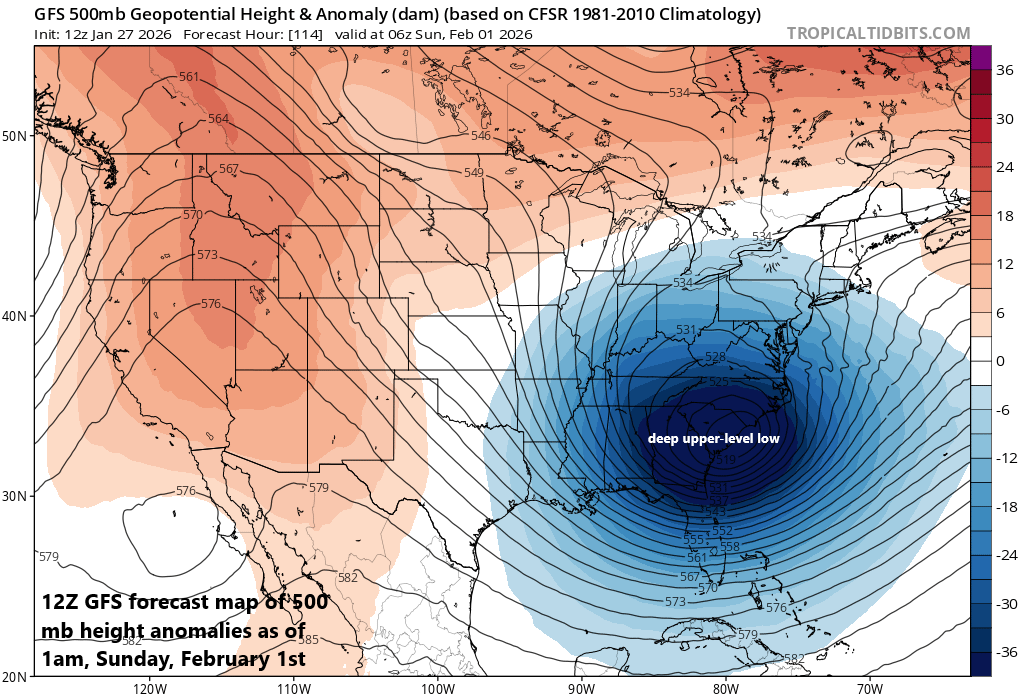
A powerful storm system is likely to develop this weekend near the eastern seaboard supported aloft by a vigorous upper-level low. Map courtesy NOAA, tropicaltidbits.com
Overview
In the wake of the major weekend winter storm, a very cold weather pattern has set up across the eastern states, and it looks like it’ll be quite a memorable stretch both in terms of magnitude and duration. A long-wave trough parked over the eastern US is allowing for the reinforcement of Arctic air masses with an especially bitter one coming to the Mid-Atlantic region for the second half of the week. Low temperatures on Wednesday night, Thursday night, and Friday night are likely to flirt with the zero-degree mark in many locations and challenge low temperature records. In addition, there may be record low high temperatures later in the week with afternoon highs likely limited to the teens - even in the big cities.
In addition to the relentless bitter cold, it looks like a powerful storm system will form this weekend somewhere near the eastern seaboard. This system is likely to have its origins over the Gulf region and then push northeastward to near the east coast while intensifying dramatically. It is still too early to determine its ultimate path, but a close trek to the coast could indeed bring significant snowfall and strong winds to portions of the northeastern states.
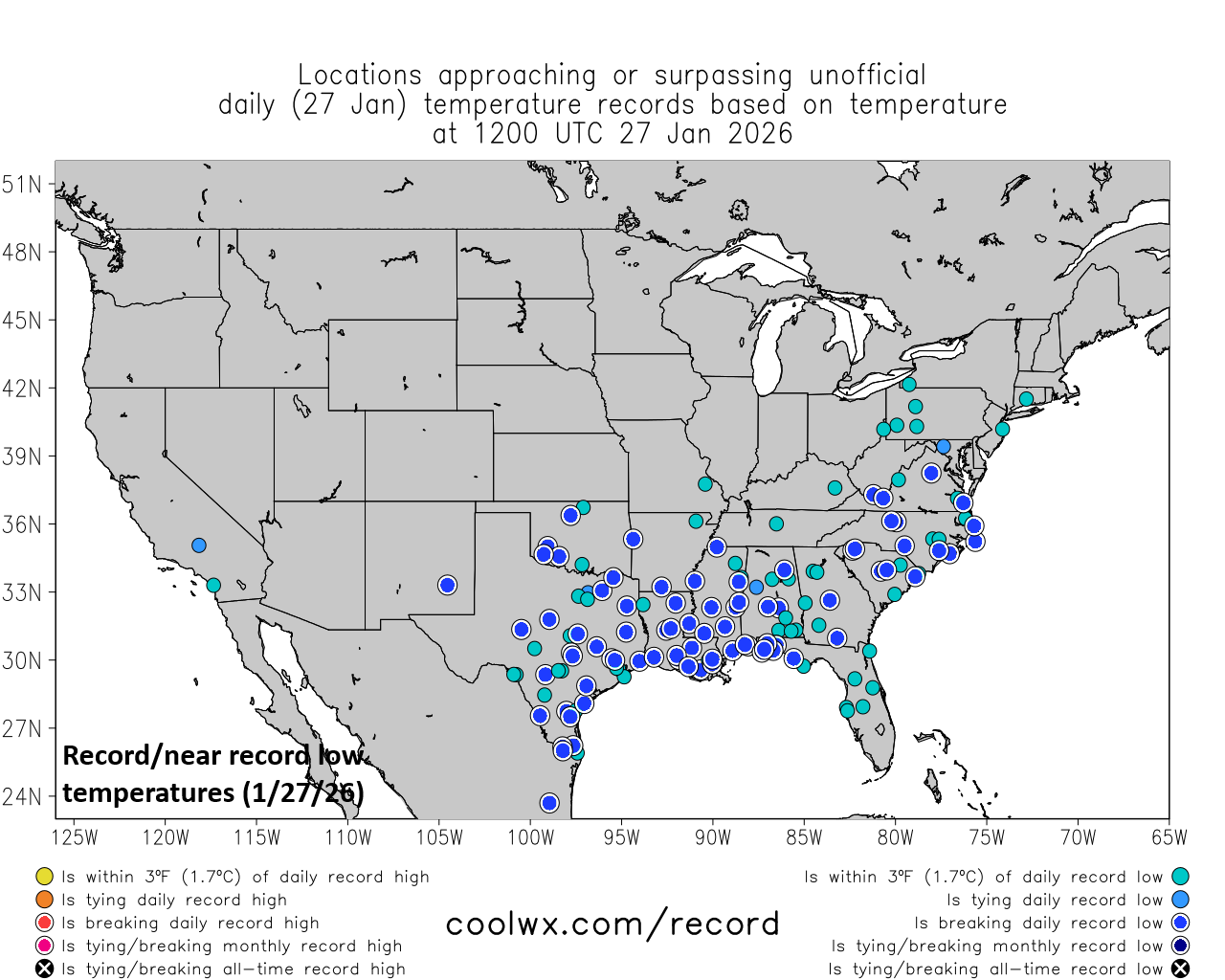
There were numerous record or near record lows this morning across much of the southern and eastern US…better get used to this. Map courtesy NOAA, coolwx.com
Details
A reinforcing shot of Arctic air arrives later tonight as a cold front sweeps through the region and temperatures will take even more of a tumble than they already have for the second half of the week. Overnight lows on Wednesday night, Thursday night, and Friday night will be at or below zero in many spots and daytime highs generally confined to the teens. The last time Philly Airport (PHL) and Reagan National Airport in Washington, D.C. (DCA) recorded temperatures below zero was in January of 1994, and the last time for Central Park in New York City was in February 2016…on the table at all three sites during this bitter cold stretch.
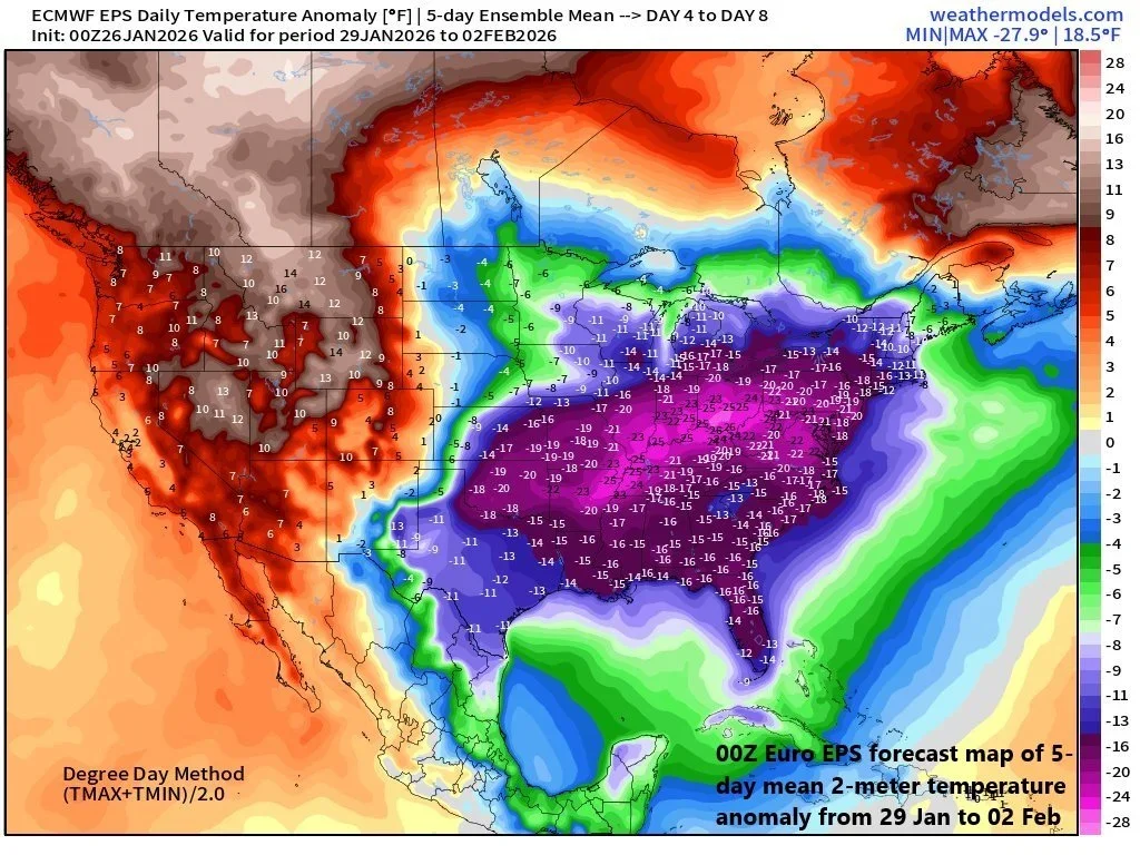
The latter part of the week and weekend will be especially cold in much of the southern and eastern US with Arctic cold impacting areas all the way to central/southern Florida. Map courtesy Euro, weathermodels.com
Other notes on the cold...record lows and record low high temperatures are on the table; especially, later this week. For example, Philly’s record low temperature on Friday, January 30th is 7 degrees set in 2019, and the record low high temperature for the date is 18 degrees set in 1965...both are in jeopardy. In NYC, the longest stretch of below freezing days is 16 and this record may become in play. Finally, this bitter cold is impacting Florida as well with the 30’s pretty widespread this morning and even colder conditions are likely later this weekend on the back side of an expected powerful coastal storm.
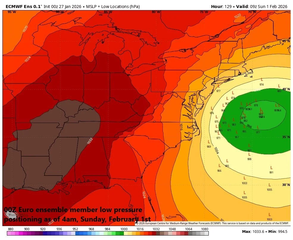
An “ensemble” run of the 00Z Euro produces numerous low pressure positions close to the east coast…a favorable sign of impact in the I-95 corridor…something to closely monitor in coming days as this looks to become quite a powerful storm system. Map courtesy ECMWF, Weather Bell, BAM Weather (X)
In terms of upcoming storm possibilities…there will likely be a powerful storm system this weekend somewhere over the western Atlantic Ocean and not far from the east coast. Signs point to a low pressure system that develops near the Gulf by the weekend and then pushes up along or near the eastern seaboard and intensifies dramatically. It is too early to say if it comes close enough to the coast for a big impact in the Mid-Atlantic/Northeast US or if it will take more of an “out-to-sea” type of track.
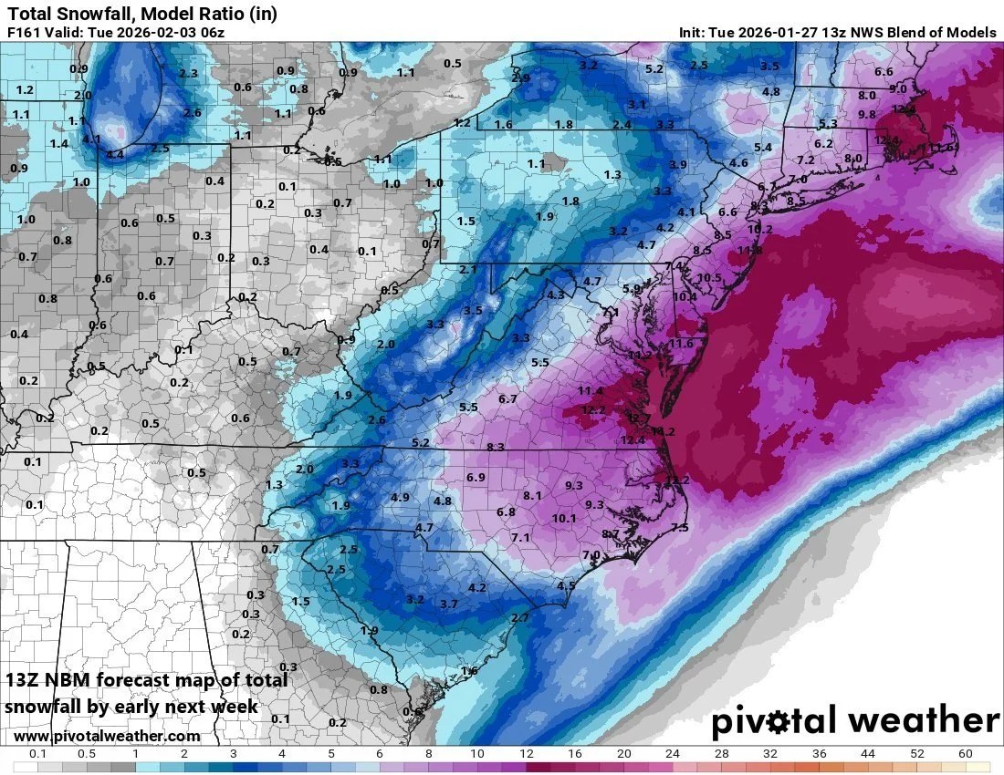
A blend of computer forecast models projects appreciable snowfall this weekend across portions of the northeastern states; especially, along coastal sections where the winds can be quite strong as well. Map courtesy NOAA, Pivotal Weather
The potential is there for significant snowfall in at least some portions of the northeastern states and strong winds as well...especially along coastal sections...as the early indications are for a dramatic intensification of the low-pressure system that begins over the Gulf region. Still several days away, and questions remain on the ultimate path, but stay tuned as there is a lot of potential with this system...and in the big picture…relentless bitter cold and storm possibilities...the worst that winter has to offer.
Meteorologist Paul Dorian
Arcfield
arcfieldweather.com
Follow us on Facebook, Twitter, YouTube
Video discussion: