**Signals point to an active week of weather surrounding Thanksgiving Day and perhaps quite interesting to Christmas...fascinating battle to watch between strong El Nino and stratospheric warming**
Paul Dorian
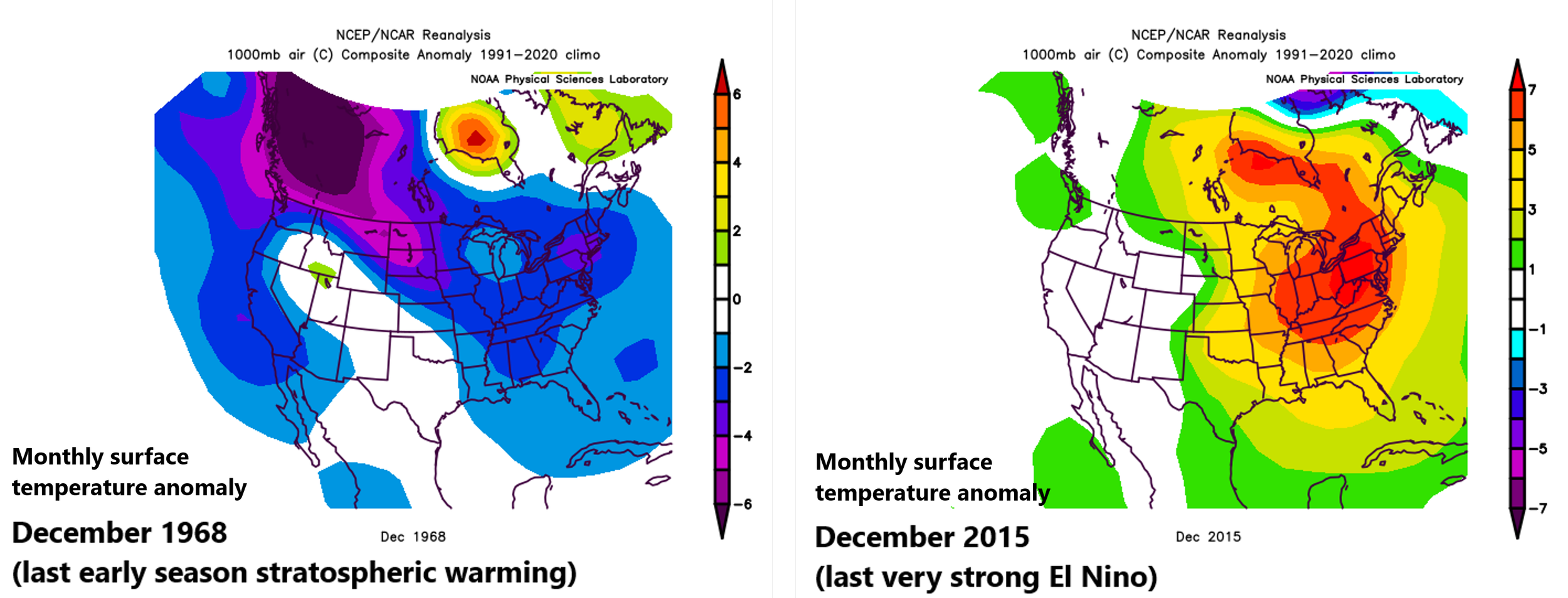
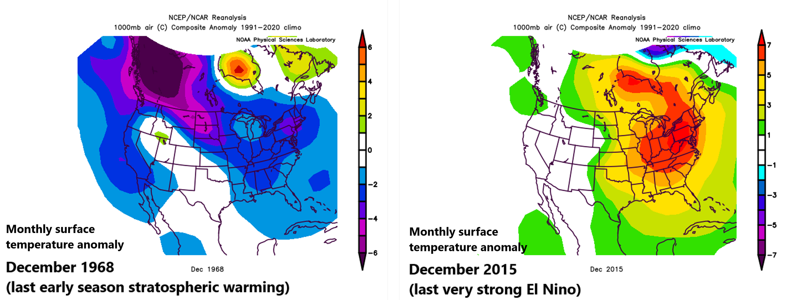
The closest analog to this month’s early season stratospheric warming event came in late November of 1968 during an El Nino event. In that case, the month of December featured colder-than-normal weather across much of the nation (left plot). The last comparable very strong El Nino episode came during 2015-2016 and December 2015 featured much warmer-than-normal weather across the eastern two-thirds of the nation (right). Map courtesy NOAA
Overview
The weather pattern is certainly quite interesting as we close in on the winter season with one of the strongest El Nino events in at least the last fifty years and one of the earliest stratospheric warming events ever recorded over the polar region of the northern hemisphere. In the past, very strong El Nino events have resulted in much warmer-than-normal conditions during December across much of the continental US including the most recent episode of 2015-2016. The current El Nino, however, is by no means your normal “east-based” event as a rare early stratospheric warming event over the polar region throws a monkey wrench in the conventional idea of a warm month of December. Indeed, there are signs of a widespread cold air outbreak later in November during what is likely to be an active Thanksgiving Day week, and signals point to the chance for additional cold air outbreaks as we progress through the first half of December. In fact, it could end up being a very interesting period of weather between Thanksgiving and Christmas.
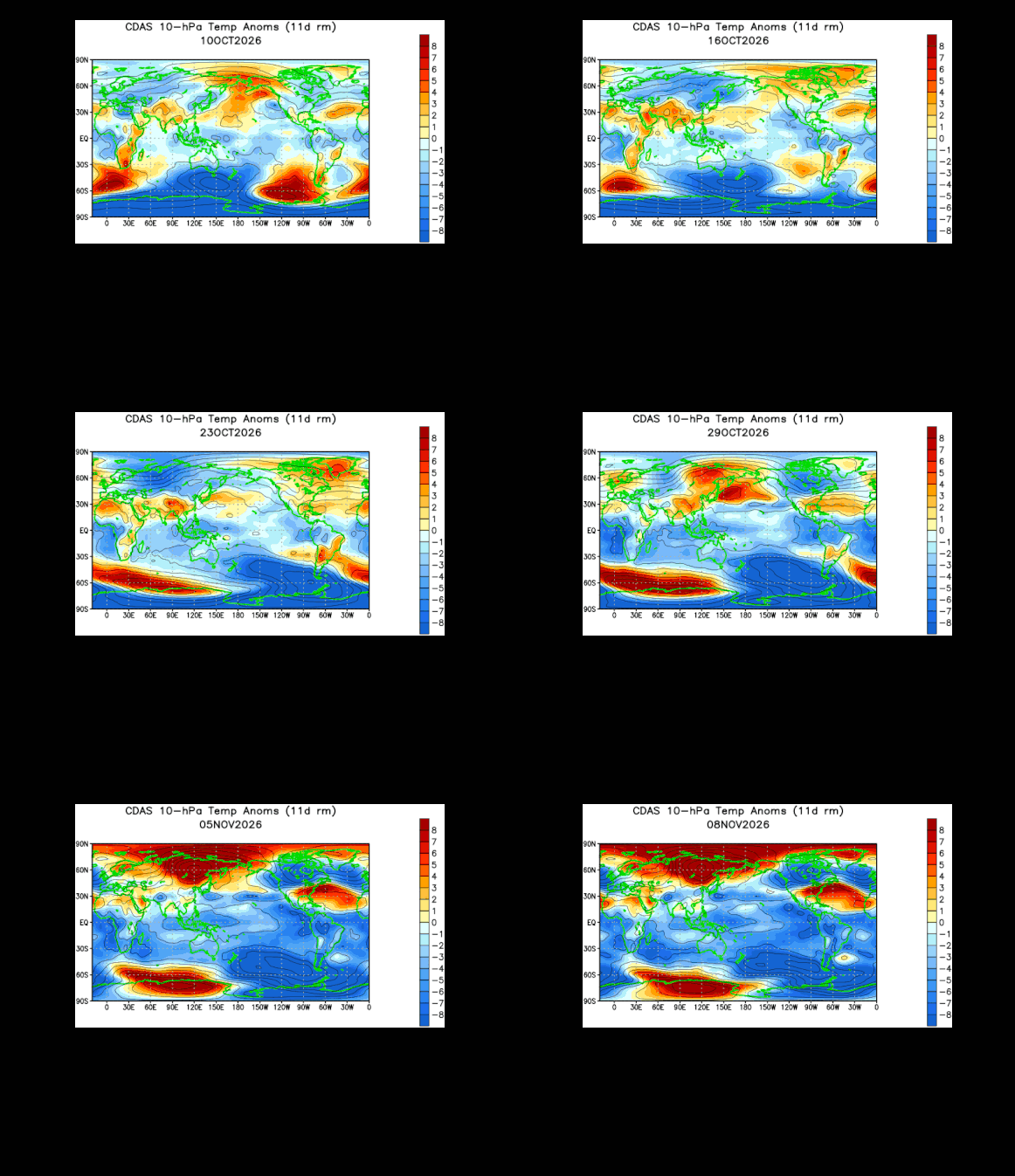
This 30-day loop of stratospheric temperatures (10 millibar level) features dramatic warming (shown in orange) over the northern hemisphere polar region in the early part of November…a very rare event for so early in the winter season. A “sudden stratospheric warming” event of this magnitude can impact temperatures across the central and eastern from later November to December…something we’ll monitor closely here during the next several weeks. Maps courtesy NOAA
Details
The current El Nino is classified as “very strong” and is certainly on par with some of the great episodes during the past fifty years including those of 1982-1983, 1997-1998, and most recently, 2015-2016. The winter season of 2015-2016 actually began with widespread warmth across the continental US in the month of December which is not at all unusual as a very strong El Nino can overwhelm the US with mild Pacific Ocean air; especially, those that have a focus in the eastern Pacific. This year, however, the notion of a warm December is thrown for a loop as we have experienced one of the earliest stratospheric warming event ever recorded in the northern hemisphere. While it certainly can still end up being a warm month of December, several signals point to at least the possibility of occasional cold air outbreaks that make their way from the high latitudes to the middle latitudes.
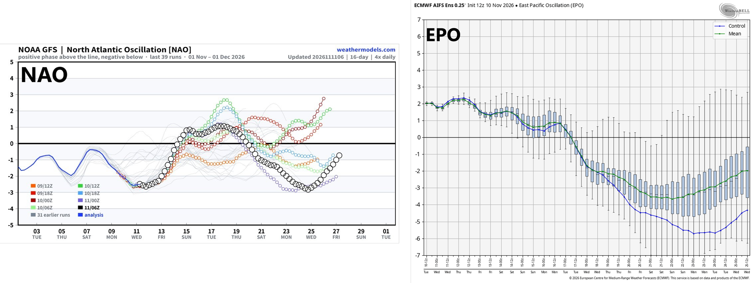
Teleconnection indices such as the NAO (left plot) and EPO (right plot) drops into “negative” territory as we progress through the later part of November and this is usually reflective of more favorable environmental conditions for cold air masses to make their way from the high latitudes into the middle latitudes. Maps courtesy NOAA, Weather Bell, weathermodels.com
In many stratospheric warming events, the impact on temperatures in the central and eastern US can begin several weeks later and it can last for several weeks...in this case, that would potentially put the focus on the time period from late November to late December or roughly, Thanksgiving-to-Christmas. A series of events in the atmosphere begins with the polar vortex disruption that can lead to the increasing likelihood for cold air masses making their way from the Arctic into the middle latitudes with the stratospheric polar vortex acting as an important cold air source.
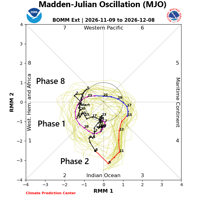
The Madden-Julian Oscillation or MJO is forecasted to move into “phases” (8, 1, 2) or locations that are more favorable this time of year for colder-than-normal weather conditions in the central and eastern US. Map courtesy NOAA, Australia Bureau of Meteorology
Teleconnection indices such as the Eastern Pacific Oscillation (EPO), North Atlantic Oscillation (EPO), and Madden-Julian Oscillation (MJO) support the idea of cold air masses dropping into the US from high latitudes as we get to late November and early December. Specifically, the EPO takes on a negative tilt later this month which is usually reflective of upper-level high pressure ridging popping up near Alaska and over the eastern Pacific. This in turn, blocks mild Pacific air from reaching the US west coast and instead forces Arctic air to plunge southward into Canada and ultimately, into the central/eastern US.
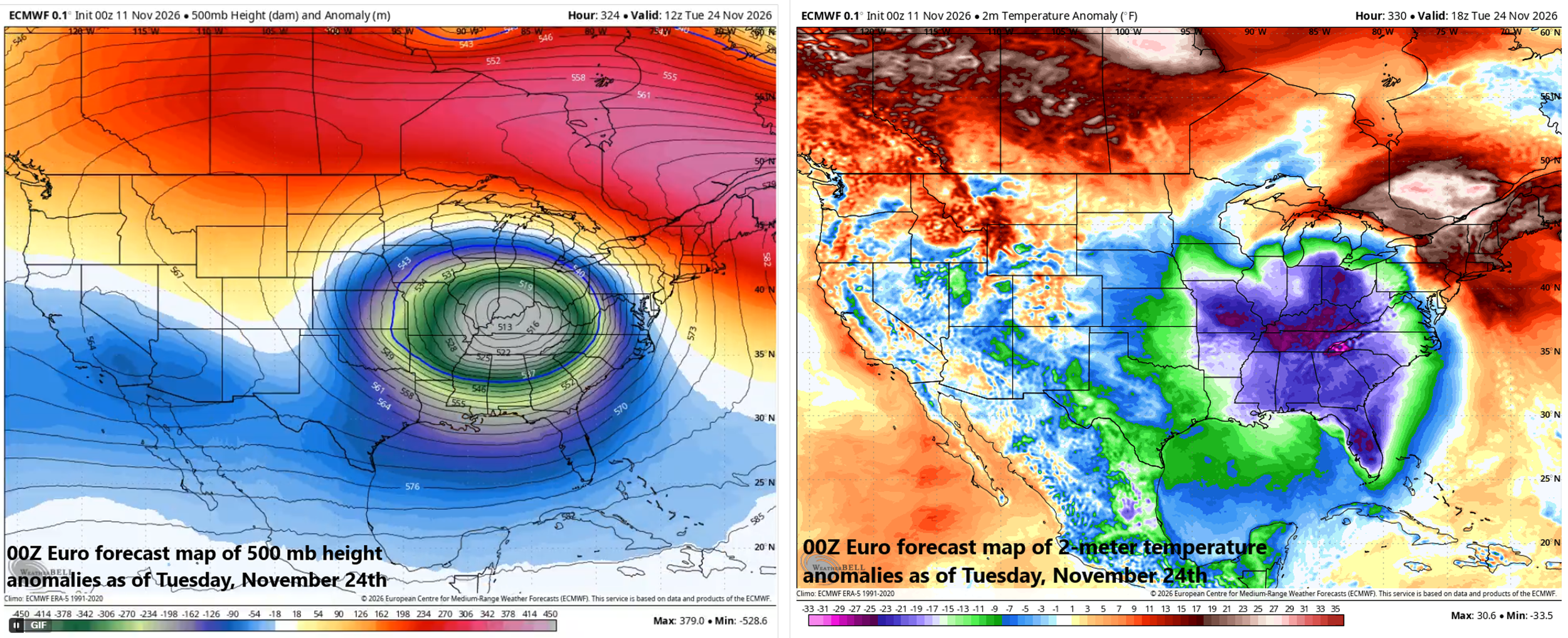
The week of Thanksgiving may be quite active as we potentially transition to a widespread colder-than-normal air mass. While still well in the future, there are signs of a very strong cold frontal pattern that could be disruptive to the all-important travel conditions during this holiday week. Maps courtesy ECMWF, Weather Bell
In addition, a negative NAO for a sustained period of time is usually reflective of a buckling jet stream, which, in turn, can lead to Arctic air outbreaks into the central and eastern US from northern Canada. Furthermore, the MJO which tracks a disturbance across the global tropics will re-position itself into what are called “phases 8, 1 and 2 as we process through late November and into early November and these locations typically favor colder-than-normal this time of year across much of the central and eastern US.
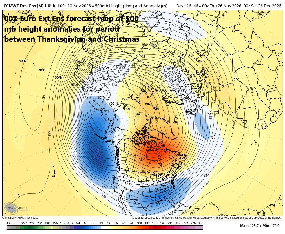
The time period between Thanksgiving and Christmas may be quite active and interesting with persistent “blocking” to the north (shown in orange), an activated sub-tropical jet to the south with upper-level trough of low pressure (shown in blue), and a deep trough over the eastern Pacific Ocean. Map courtesy ECMWF, Weather Bell
As it turns out, Thanksgiving week may be an important transition period with active weather quite possible including a very strong cold front that could cross the country with quite warm air on its front side. The strong cold front could be accompanied by a deep upper-level trough of low pressure, and this combination could lead to rain, snow and strong thunderstorms during a week in which travel conditions are always in focus. Ultimately, much of the nation that holiday week could feature much colder-than-normal conditions on the heels of a strong cold frontal passage.
Stay tuned...this is all in the “speculation” phase at this point, but it might be an interesting week of weather surround the Thanksgiving Day holiday and perhaps an interesting month of December as well.
Meteorologist Paul Dorian
Arcfield
arcfieldweather.com
Follow us on Facebook, Twitter, YouTube
Video discussion: