*Polar vortex disruption is now underway...a very rare event for so early in the season...potential winter-like consequences later November and December*
Paul Dorian
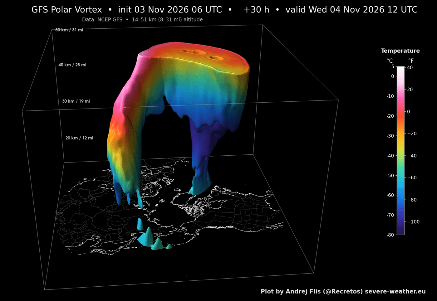
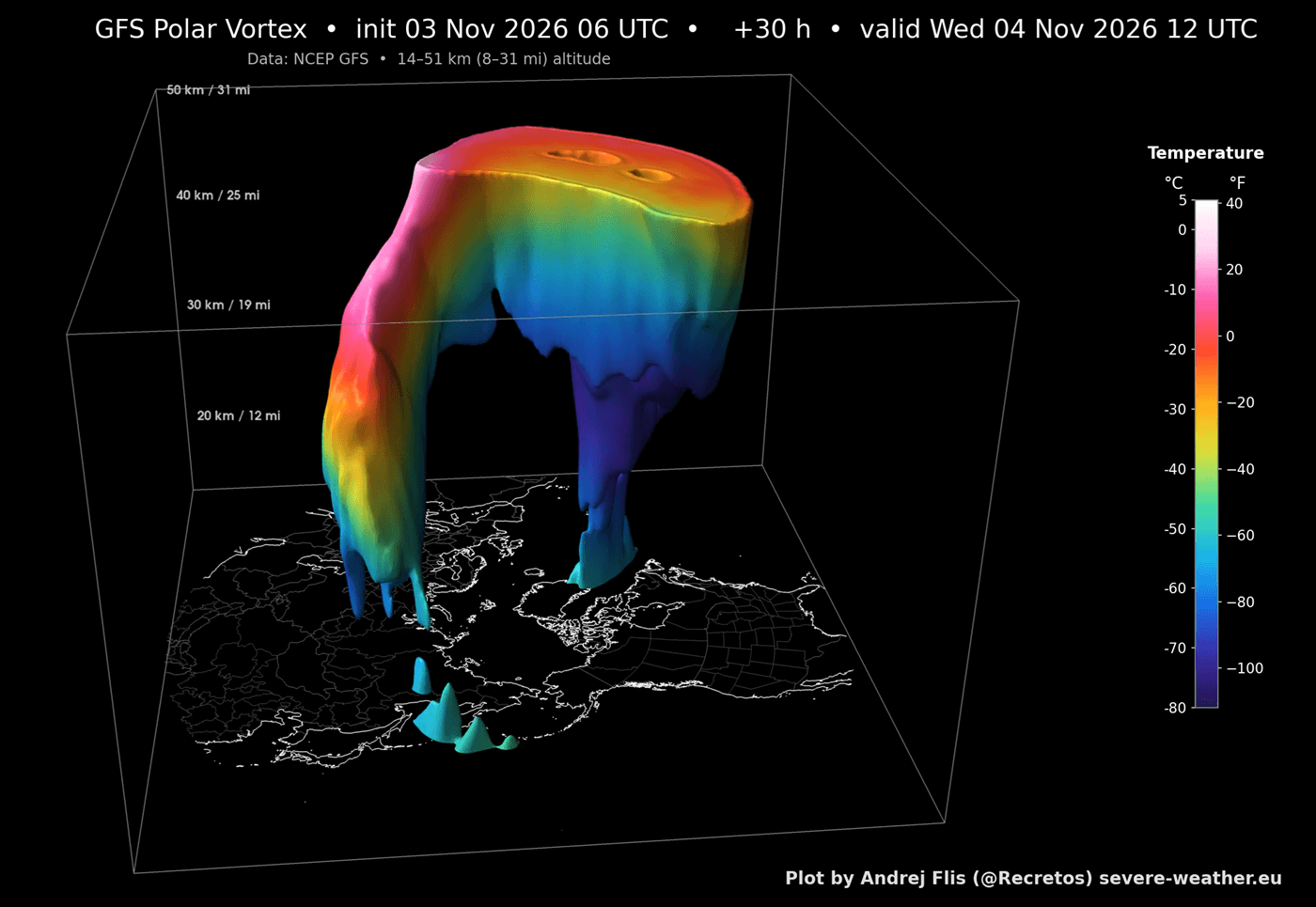
A 3-D view of the current polar vortex temperature pattern at the stratospheric level (10-mb) shows well a “split” with two separate pieces over the Northern Hemisphere. This polar vortex disruption can set off a chain of events in the atmosphere that can result in cold air outbreaks from the high latitudes to the middle latitudes in weeks to come. Graphic courtesy NOAA (GFS) and severe-weather.eu
Overview
An unusually early polar vortex disruption is now underway in the Northern Hemisphere, and it could have winter-like implications on the weather across portions of the continental US later this month and during the month of December. In a typical strong El Nino winter season, mild Pacific Ocean air can overwhelm the nation, but this rare early season polar vortex disruption throws a monkey wrench into the whole concept of a “normal” El Nino winter season. An analysis of upper-level data records going as far back as the 1950’s show just how rare this polar vortex disruption is with the closest analog coming in late November of 1968...some three weeks later than the current rare early season event.
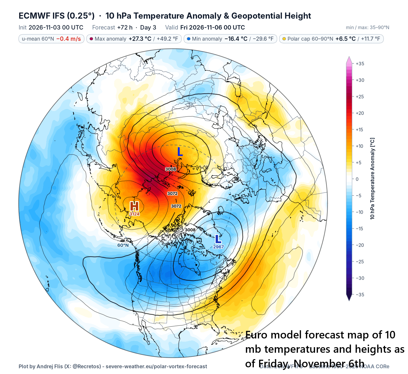
By the end of this week, the polar vortex will be split into two parts and both pieces will be surrounded by areas of stratospheric warming (orange). Map courtesy ECMWF, severe-weather.eu
Details
A stable polar vortex is typically positioned in the upper atmosphere near or over the North Pole this time of year surrounded by strong westerly winds roughly around the 60°N latitude belt. Occasionally, atmospheric energy waves (called Rossby waves) travel upward from the lower atmosphere (troposphere) into the stratosphere causing a slowing down of the westerly winds and causing temperatures high up in the atmosphere to spike dramatically. In fact, if the average zonal (west-to-east) winds at 60 degrees north latitude completely break down so that the average flow runs “backward” (i.e., easterly), meteorologists will qualify this as a major “Sudden Stratospheric Warming (SSW)” event. Indeed, the westerly winds at this latitude have weakened significantly in recent days and a complete reversal of direction from westerly to easterly is looking likely during the next week or so...in other words, a major SSW event, extremely rare for so early in the season.
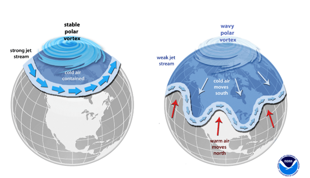
A stable polar vortex is typically surrounded by a band of fast-moving westerly winds (left), but a disruption can lead to a slowing of those “zonal” winds or even a complete reversal in direction to easterly. A polar vortex disruption will usually result in a “buckling” of the upper-level jet stream (right) which can, in turn, unleash cold air masses from the high latitudes to the middle latitudes. Graphic courtesy NOAA
When the westerly winds stop and reverse in the upper atmosphere, the normal tight containment of the vortex and cold air collapses. The polar vortex either stretches, becomes distorted, or splits into multiple pieces. Current forecast models suggest in this case the polar vortex will stretch and split into two pieces with dramatic stratospheric warming taking place surrounding the split vortices.
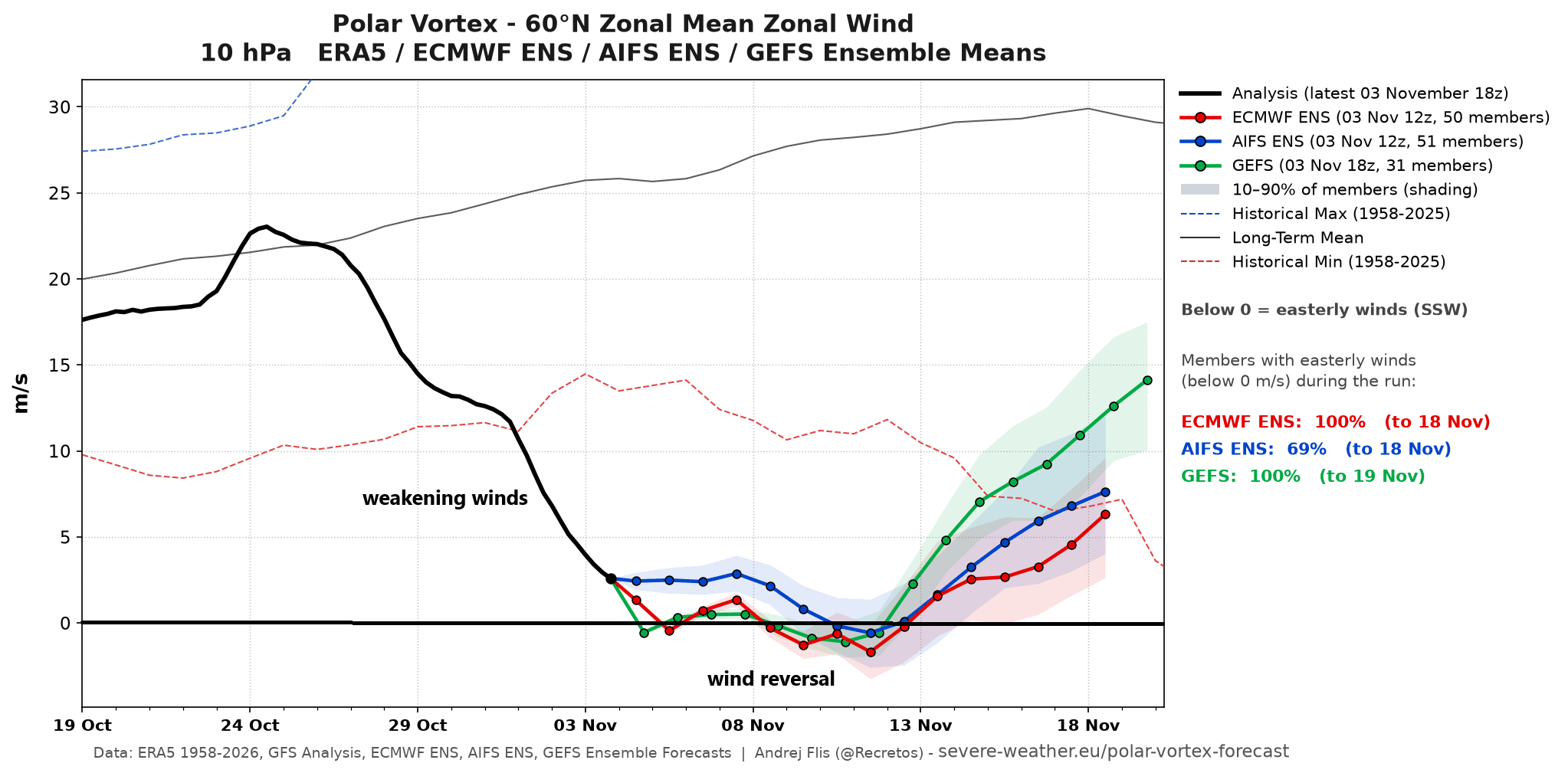
Westerly winds at the stratospheric level around 60 degree north latitude have weakened dramatically in recent days and can reverse in direction during the next few days…meeting the threshold of a major “sudden stratospheric warming” event. Plot courtesy NOAA< ECMWF, severe-weather.eu
This disturbance in the upper atmosphere works its way toward the lower atmosphere, warping the jet stream. Instead of slowing from the normal west-to-east (or called zonal) direction and keeping Arctic air bottled up tightly at high latitudes, the jet stream buckles into large loops, and this allows for the transport of Arctic air into the middle latitudes including parts of the US, often to the east of the Rockies. The whole process from the initial disruption of the polar vortex to the unleashing of the Arctic air can take weeks to unfold which raises the can In terms of potential ramifications on the weather, a polar vortex disruption can promote a more wavy, meridional jet stream pattern, which – in this scenario – suggests there can be winter-like consequences later in November and during the month of December.
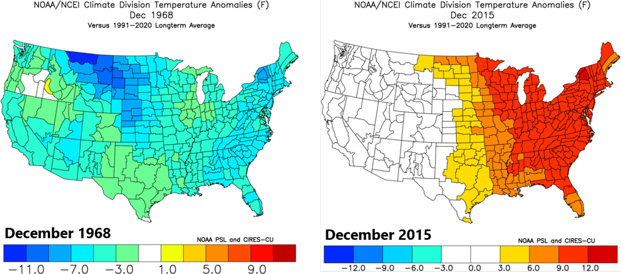
The closest analog to this early season polar vortex disruption came in late November 1968 which happened to be followed by quite a cold nation in December. Meanwhile, the closest analog to the current very strong El Nino came in 2015-2016 and not at all like December 1968, much warmer-than-normal weather dominated across the eastern half of the nation. Maps courtesy NOAA
Stay tuned...this very rare early season polar vortex disruption/stratospheric warming event combined with very strong El Nino conditions could make for quite an interesting latter part of the fall and beginning to the winter season.
Meteorologist Paul Dorian
Arcfield
arcfieldweather.com
Follow us on Facebook, Twitter, YouTube
Video discussion: