*The development of El Nino...already impacting the atmosphere across the nation with an enhancement of severe weather risks and better opportunities for rain from the Rockies to Mid-Atlantic*
Paul Dorian

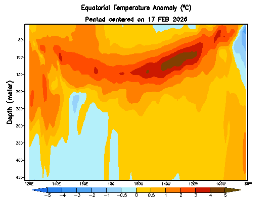
Sub-surface water temperature anomalies (°C) down to a depth of 450 meters are shown here from the equatorial part of the Pacific Ocean in the period from 17 February 2026 to 18 April 2026. Much warmer-than-normal water (shown in orange/brown) is now lurking just beneath the surface (top) across much of the tropical Pacific and the cold water (shown in blue) at and just below the surface level has tended to shrink in extent in recent days. Map courtesy NOAA/CPC, International Research Institute [Note – “Nino 3.4” region is 120°W-170°W.]
Overview
As noted in the 2026 Tropical Outlook, El Nino is likely to be a major player with respect to the upcoming tropical season in the Atlantic Basin and all signs continue to point to the increase of water temperatures in the equatorial Pacific Ocean. Not only have surface water temperatures climbed dramatically in the tropical Pacific Ocean in recent days, but some very warm water lurks just beneath the surface, and it is “bubbling” up to the top.
The development of El Nino in the tropical Pacific is actually having some current effects on the upper air flow across the continental US with a more favorable environment for severe weather outbreaks and better opportunities for rain from the Rocky Mountain States to the Mid-Atlantic region. Looking ahead, the combination of an El Nino episode in the Pacific Ocean and an area of cooler-than-normal water in the Atlantic’s Main Development Region may result in below-normal tropical activity in the Atlantic Basin during the summer and fall seasons. Should El Nino continue into the 2026-2027 winter season - and odds are good - it would also have big implications for the weather across the continental US...something we’ll monitor in the months to come.
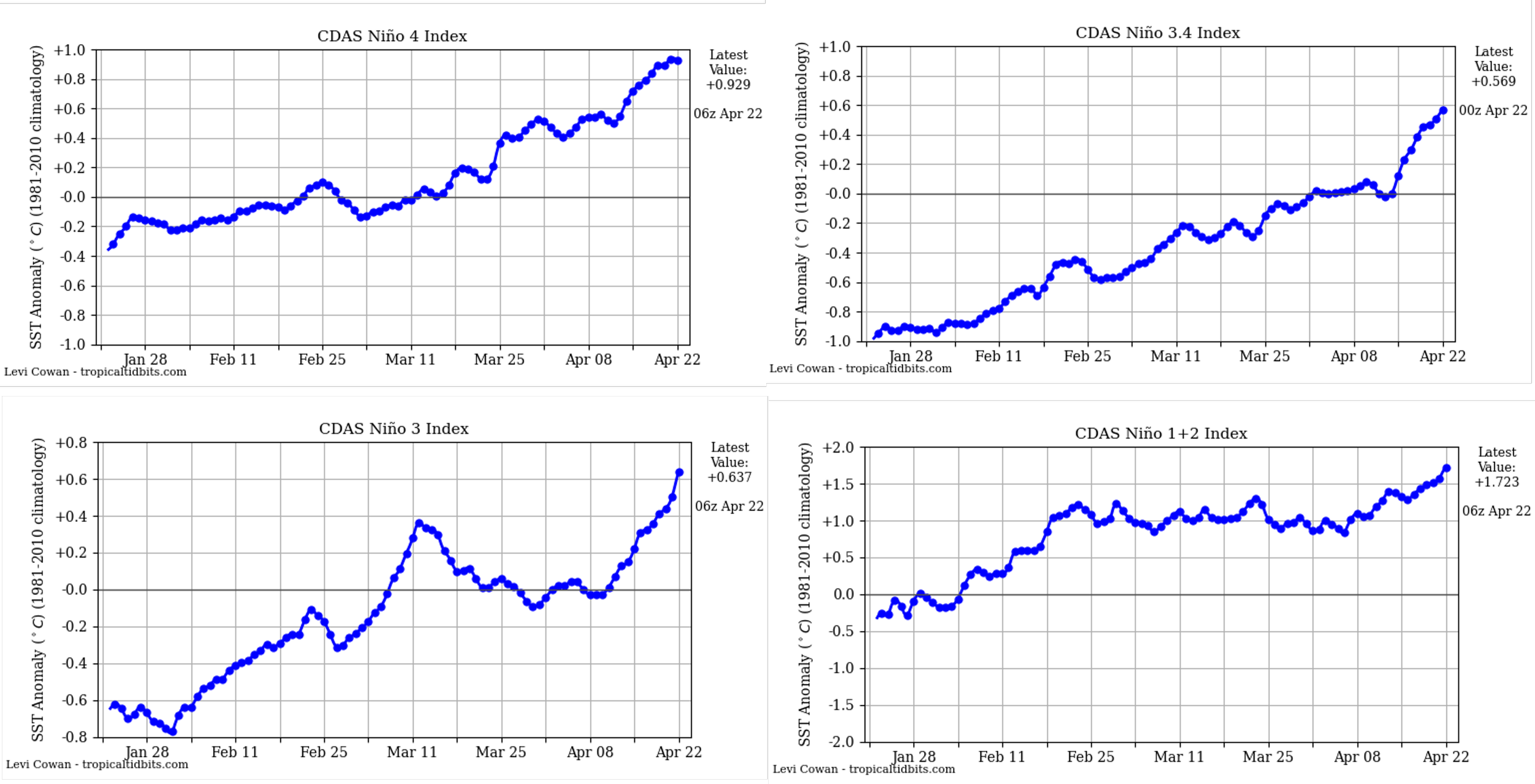
Water temperatures have climbed dramatically in recent days across all four “regions” of the tropical Pacific Ocean as El Nino conditions become better established. Plots courtesy NOAA, tropicaltidbits.com
The development of El Nino
Meteorologists separate the world’s largest ocean into four regions as a way of better pinpointing specific areas in the tropical Pacific and all are experiencing rapid water temperature rises in recent days. In fact, all four regions now feature water temperatures that are above-normal with the warmest relative-to-normal being the far eastern region known as “1+2” that sits just off the west coast of South America.
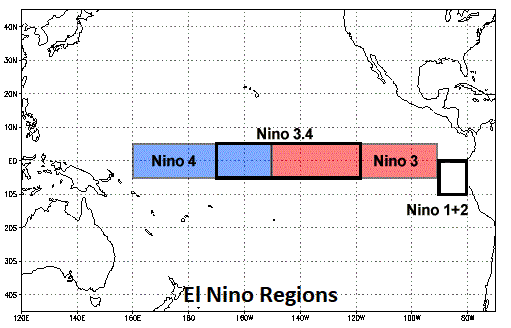
The El Nino region of the Pacific Ocean is sub-divided by meteorologists into sub-sections as outlined on this map with “Nino 3.4” region (5 °N-5°S, 120°W-170°W, boxed region in middle) in the central part of the equatorial Pacific Ocean and “Nino 1+2” (boxed region at right) positioned near the west coast of South America.
Meanwhile, deep-sea buoys in the tropical Pacific Ocean are measuring water temperatures that are far above normal, and all indications are that this warm water is “bubbling” up to the top. These deep-sea buoys in the Pacific TAO (Tropical-Atmosphere Ocean) array operate as part of NOAA’s National Data Buoy Center and have undergone significant upgrades since the original array was completed in 1994. These instruments can capture water temperatures on a frequent basis all the way down to 450 meters beneath the surface...critical real-time observations in the monitoring of El Nino or La Nina in the world’s largest ocean. (Credit to Meteorologist Dr. Louis Uccellini on “deep-sea buoy” information)
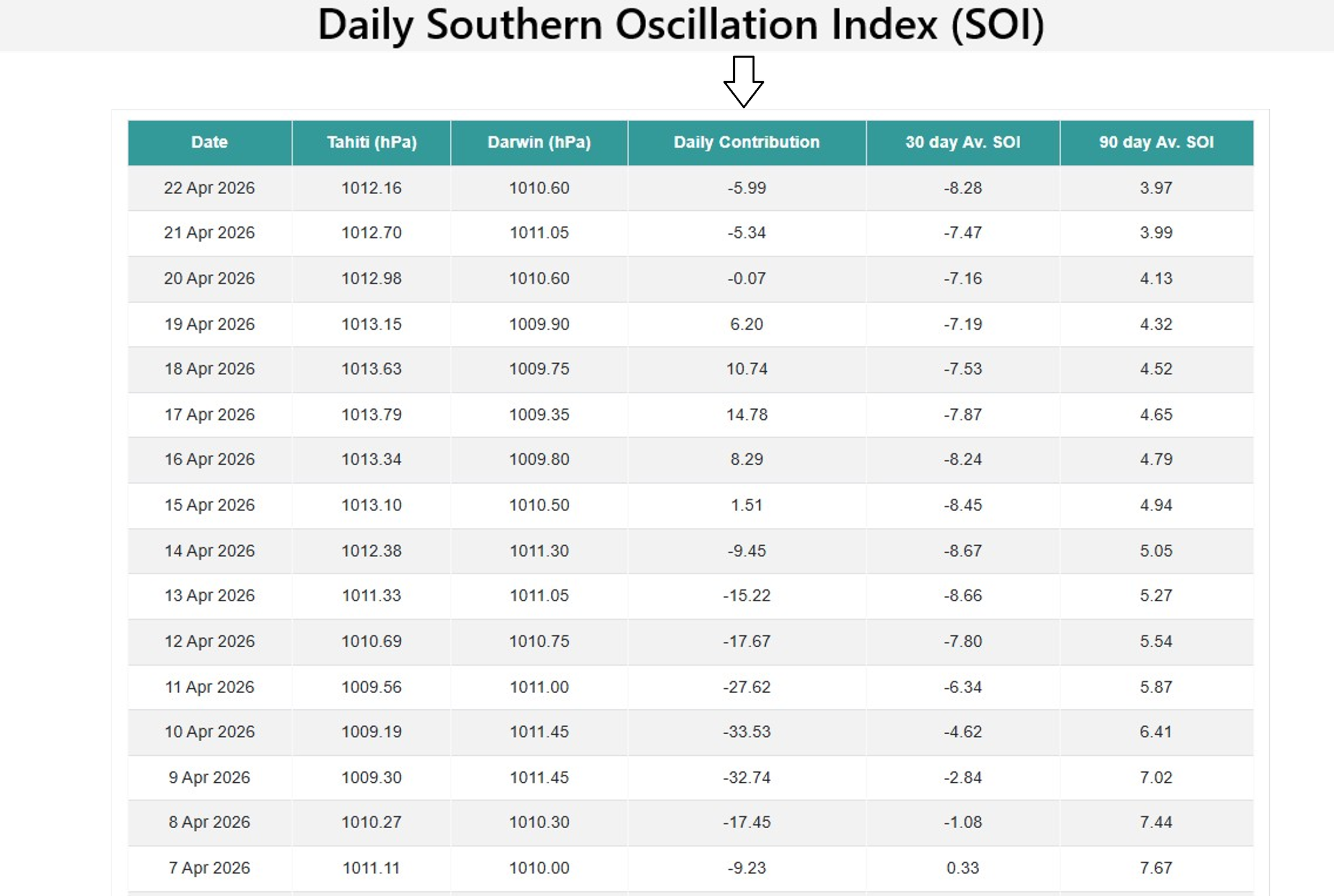
A teleconnection index known as the Southern Oscillation Index or SOI is showing signs of a developing El Nino in the tropical Pacific. This index is calculated by using pressure differences between two southern hemisphere locations (Darwin and Tahiti) and, if in “negative” territory for a sustained period, El Nino conditions will usually be detected.
In addition to these water temperatures observations at the surface and beneath, a teleconnection index known as the Southern Oscillation Index or SOI supports the idea of an incoming El Nino. This index is calculated using the pressure differences between two southern hemisphere regions (Darwin and Tahiti) and when it is in “negative” territory for a sustained period that is usually correlated with El Nino conditions (i.e., warmer than normal water in the Pacific Ocean).
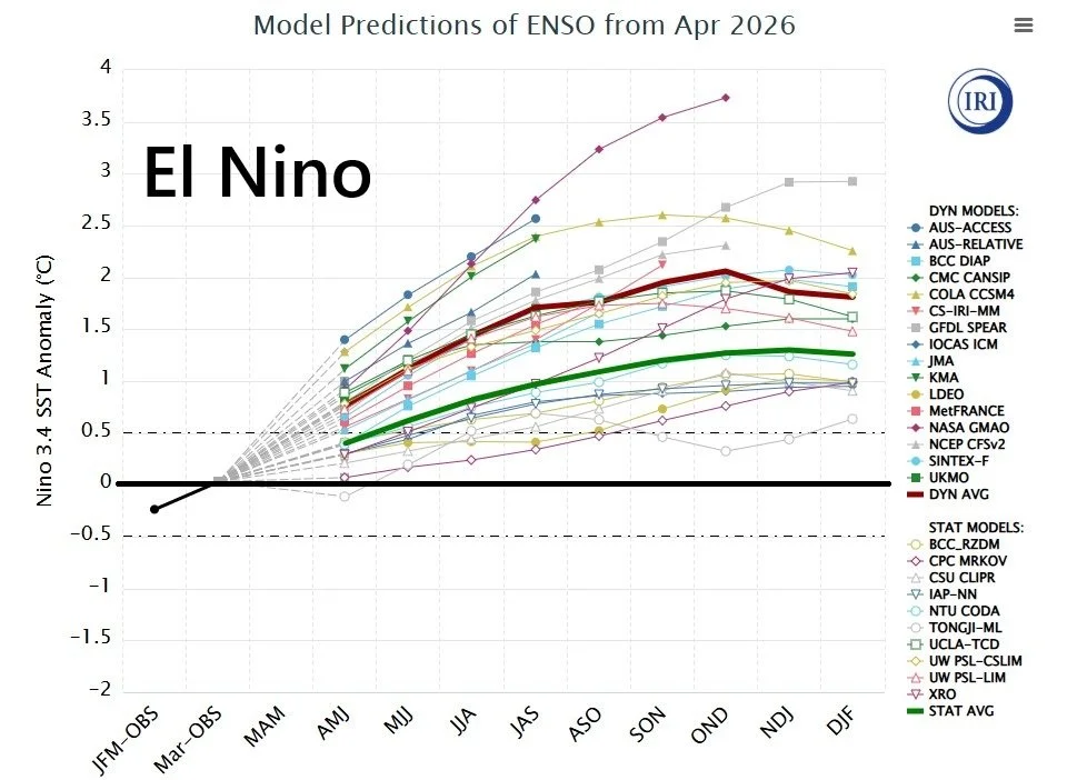
Forecasts of sea surface temperature (SST) anomalies are shown for the “Nino 3.4” region (5 °N-5°S, 120°W-170°W) of the tropical Pacific by a compilation of computer forecast models with general agreement on El Nino conditions after brief period of “ENSO-neutral”. The computer models encompass two types – statistical and dynamic – with the average of each highlighted (red for dynamic, green for statistical). Plot courtesy NOAA, ECMWF, JMA, KMA, Canadian Met Centre, International Research Institute
The SOI was in “negative” territory for a while earlier this month and then returned to “positive” territory for several days, but negative numbers have re-appeared during the past few days. I expect to see this index to drop further into “negative” territory in coming days and El Nino will become more and more established in the equatorial Pacific. Finally, further support for an increasingly strong El Nino event comes from computer forecast models which almost universally predict water temperatures to reach well above neutral levels in time for the summer tropical season in the Atlantic Basin.
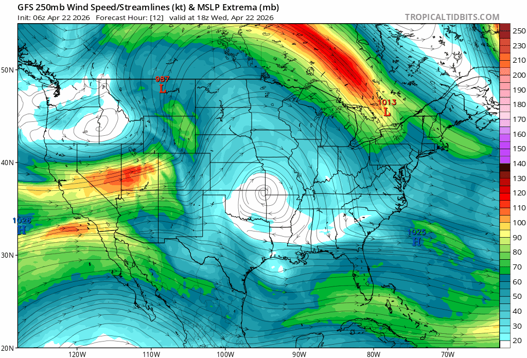
One of the immediate responses by the atmosphere to a developing El Nino will be intensification of the upper-level jet stream across the continental US and a general shifting to the south. This response will lead to higher risks of severe weather in coming days and likely increasing precipitation from the Rocky Mountain States to the Mid-Atlantic region. Maps courtesy NOAA, tropicaltidbits.com
Near-term impacts with the formation of El Nino...severe weather outbreaks...cooler pattern and increased precipitation from the Rockies to the Mid-Atlantic
As El Nino begins to get better established in the Pacific, the upper part of atmosphere appears to already be undergoing some important changes across the continental US. Specifically, the jet stream across the US appears to be shifting gradually to south in response to the development of El Nina and may drop all the way to the US/Mexico border by the early part of May with troughs aloft digging farther to the south. The response by the atmosphere to the developing El Nino will have noticeable effects on weather across the US with, for example, better setups for severe weather outbreaks; especially across the central states, and the next several days will have that kind of risk.
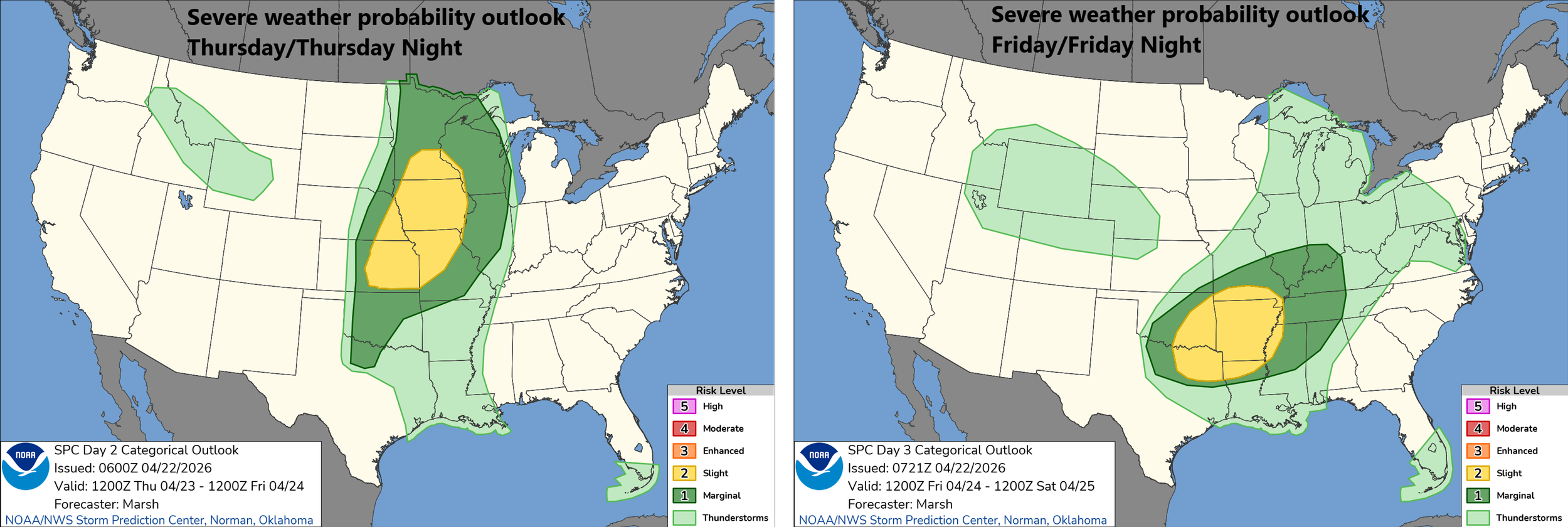
With an intensifying and shifting jet stream in response to the development of El Nino, the risk of severe weather will be enhanced in coming days; especially, across the central states. Maps courtesy NOAA/SPC
In addition, with upper-level troughs digging farther and farther to the south, it’ll turn cooler from the Rockies to the Mid-Atlantic region and the chance for precipitation will increase...welcomed news as dry conditions have prevailed in most areas. In the Mid-Atlantic region, some decent rain is likely on Saturday, and a soaker is possible around next Tuesday or so...other opportunities for rain will follow during the next ten days or so. Another impact by El Nino which was highlighted in the 2026 Tropical Outlook will be increased wind shear this summer across portions of the Atlantic Basin (e.g., Caribbean Sea) and this should be an inhibiting factor on overall tropical activity.
Meteorologist Paul Dorian
Arcfield
arcfieldweather.com
Follow us on Facebook, Twitter, YouTube
Video discussion: