
***Severe weather risk later Monday/Monday Night with a focus on Missouri, Illinois and Indiana...threats to continue into May with an active jet stream and additional cold air outbreaks***
Paul Dorian
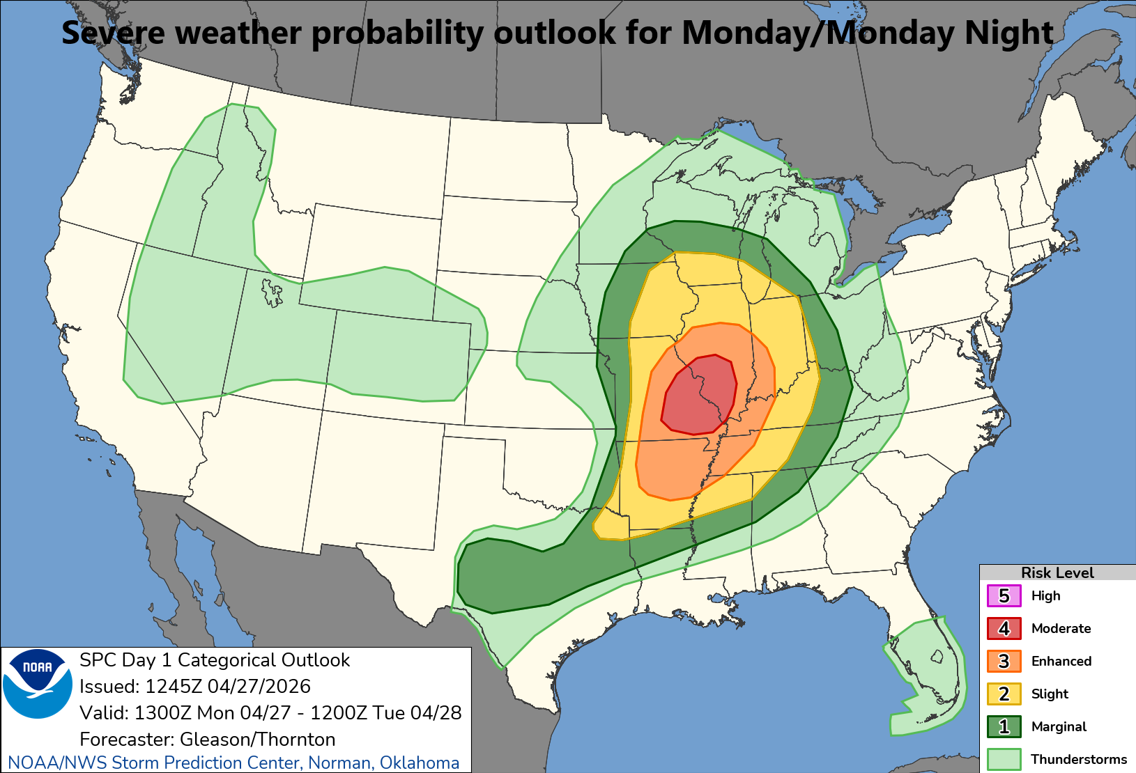
There is an “enhanced” to “moderate” risk of severe weather later today and tonight across the middle Mississippi Valley region with the concentrated threat region from Arkansas to Indiana. Map courtesy NOAA/SPC
Overview
A combination of ingredients will come together later today and tonight to enhance the risk of severe weather in the Middle Mississippi Valley region with a focus on the region from Arkansas to Indiana. One of the contributing factors in today’s severe weather threat is an active jet stream that has intensified in recent days across the central and southern US in an atmospheric response to the initial phase of El Nino in the tropical Pacific. The threat of severe weather will shift slightly to the south and east on Tuesday mainly to the Middle and Lower Mississippi Valley regions. In fact, the threat of severe weather will likely continue well into the month of May as additional cold air masses are destined to drop southeastward from central Canada into the northern US. This evolving weather pattern will produce below-normal temperatures across much of the eastern half of the nation from late April into at least the middle of May and multiple rain events are likely to be included from the Rockies to the eastern seaboard.
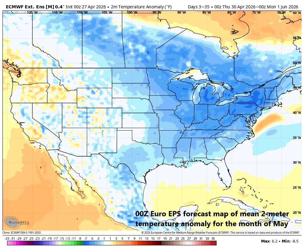
Colder-than-normal conditions appear likely in much of the eastern half of the nation during the month of May. Map courtesy ECMWF, Weather Bell Analytics
Details
Severe weather is quite likely to develop later today and continue tonight across the middle Mississippi Valley region with a concentrated risk in the region from northern Arkansas to western Indiana. The combination of strong surface low pressure, an active jet stream, an influx of warm, humid air, and an advancing colder-than-normal air mass will destabilize the atmosphere, and this severe weather risk will include the possibility of intense tornadoes (EF-3+). The genesis of El Nino in the tropical Pacific is having some current effects on the weather across the continental US as the jet stream has become more active and has shifted farther south compared to its usual location this time of year. A more active jet stream and a shift to the south results in areas of enhanced upward motion across the nation’s mid-section...all of which play an important role in severe weather outbreaks. With the southward displacement of the jet stream, colder than normal air masses from central Canada have a much better chance of penetrating into the northern US and this will likely result in colder-than-normal weather during at least the next ten days or so across much of the eastern half of the nation. In fact, some teleconnection indices such as the Madden-Julian Oscillation (MJO) and North Atlantic Oscillation (NAO) suggest the colder-than-normal temperature pattern could last throughout much of May in the eastern half of the nation.
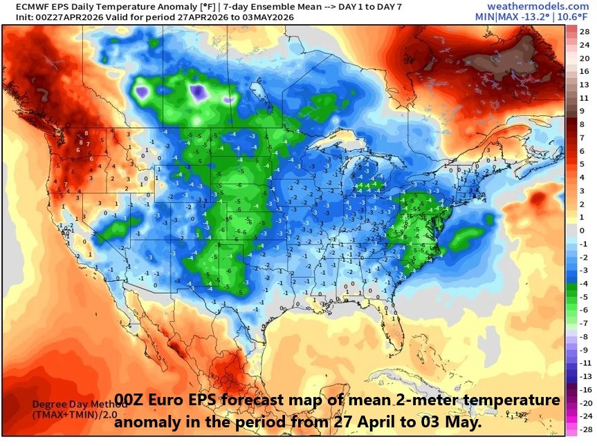
Colder-than-normal conditions appear likely in much of the eastern half of the nation during the period of April 27th to May 3rd. Map courtesy ECMWF, weathermodels.com
In addition to the chillier pattern, an active jet stream that has shifted southward in recent days to the central and southern US will allow for multiple upper-level lows to move through the Great Lakes, Mid-Atlantic and Northeast US. The bottom line here is that multiple rain events are on the table during the next couple of weeks from the Rockies to the eastern seaboard...generally welcomed news in what has been a dry section of the nation in recent weeks. Indeed, there was some beneficial rainfall this past weekend in the Mid-Atlantic region, and another round of welcome rain is on the way from later Wednesday to early Thursday. This mid-week rain event for the Mid-Atlantic could include some strong-to-severe thunderstorm activity late Wednesday; especially to the south of the PA/MD border. Another rain event is possible early this weekend in the Mid-Atlantic region depending on the exact movement of a coastal storm system.
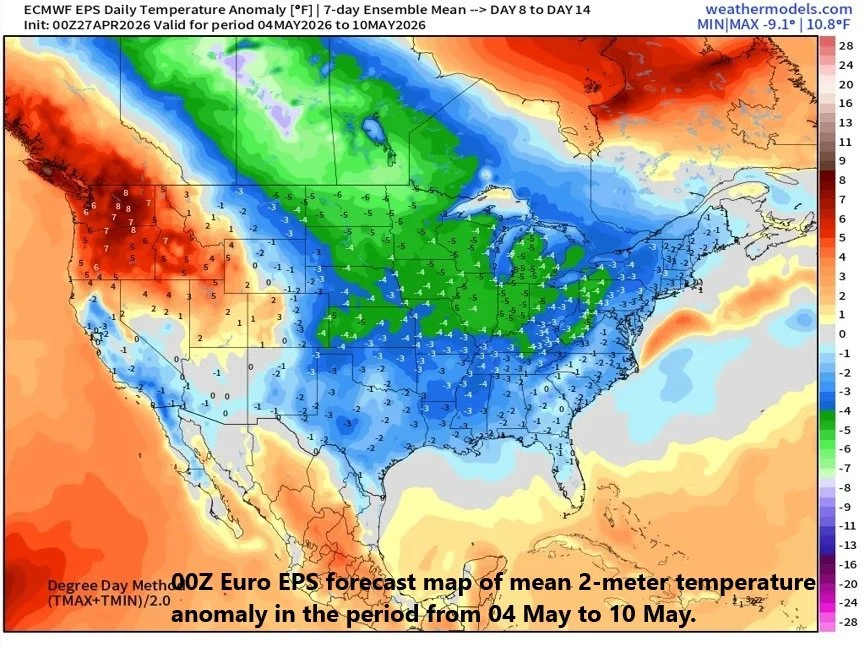
Colder-than-normal conditions appear likely in much of the eastern half of the nation during the period of May 4th to May 10th. Map courtesy ECMWF, weathermodels.com
Longer term, the development of El Nino in the tropical Pacific Ocean should lead to increased wind shear (change of wind speed and direction with altitude) in much of the Atlantic Basin including the Caribbean Sea and Gulf of Mexico. As a result, the upcoming tropical season is likely to turn out to be less active than normal in the Atlantic Basin (2026 Tropical Outlook) as low-level wind shear can disrupt circulation centers…an inhibiting factor for tropical storm formation or intensification.
Meteorologist Paul Dorian
Arcfield
arcfieldweather.com
Follow us on Facebook, Twitter, YouTube
Video discussion: