***Severe weather on Wed/Wed Night with multiple strong tornadoes a risk...a multi-day extreme rain/flooding event...both of which will be focused on the Middle MS Valley/TN Valley/Ohio Valley***
Paul Dorian
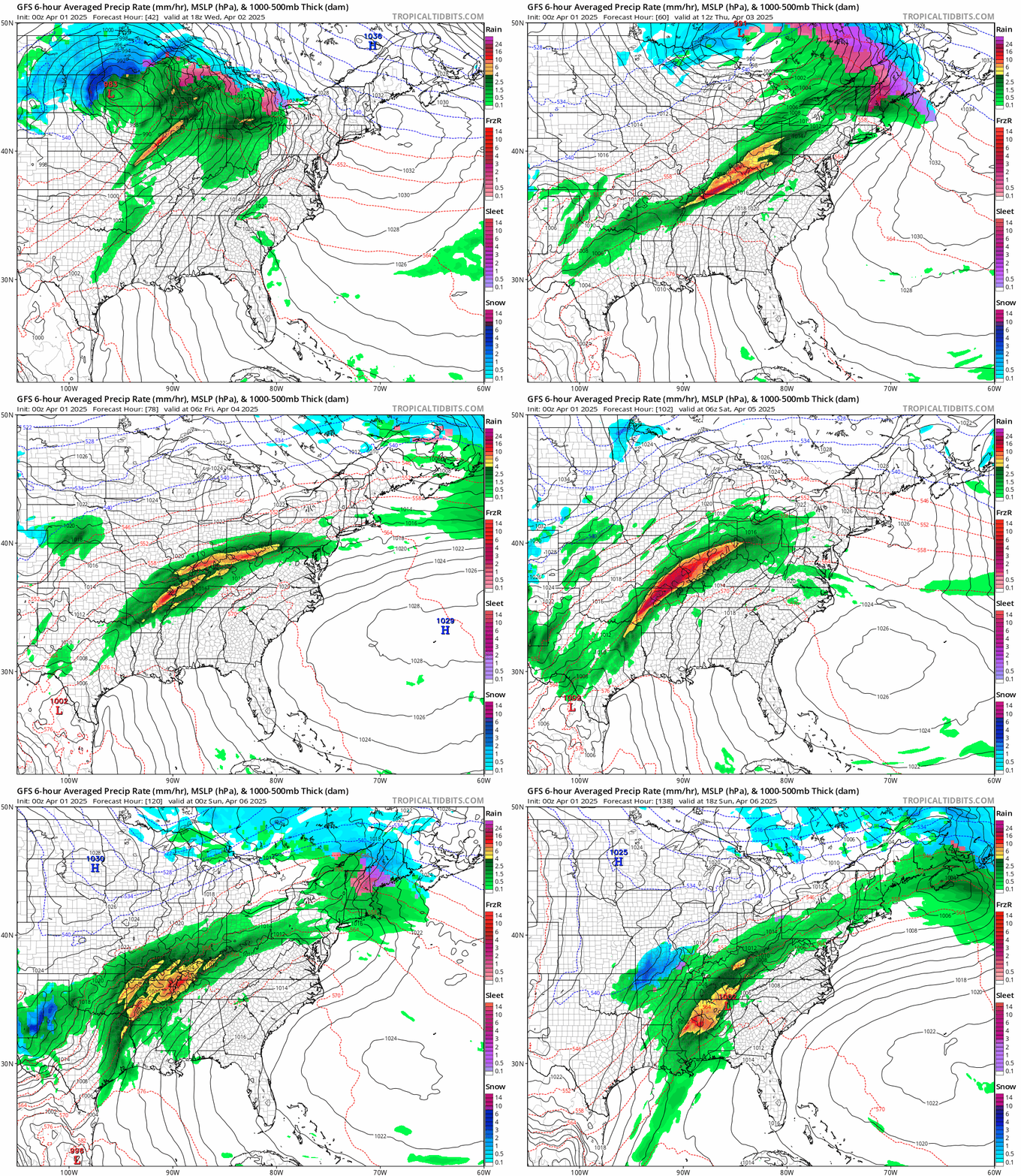
An extreme rain event is on the table for the Middle Mississippi Valley/Tennessee Valley/Ohio Valley between later tomorrow and the late weekend with a foot or more on the table. Ground conditions are rather moist in this part of the nation even before heading into this potential extreme event raising concern for widespread flooding issues in coming days. The loop of surface maps shown from the 00Z GFS model run depict multiple rounds of heavy rain in coming days along what will be a stalled-out frontal boundary zone. Maps courtesy NOAA, tropicaltidbits.com
Overview
An on-going active weather pattern will result in strong-to-severe thunderstorms later today and tonight across the middle of the country and there can be isolated tornadoes as well. On Wednesday and Wednesday night, the severe weather threat will become enhanced across the Middle Mississippi Valley/Tennessee Valley and Ohio Valley and, this time, multiple strong tornadoes will be on the table. In this same part of the nation, it appears that a multi-day extreme rainfall event is on the way from later tomorrow through the upcoming weekend with widespread serious flooding a real concern.
Severe weather is a threat today across the middle of the nation particularly across Oklahoma and Kansas and the threat becomes even more widespread on Wednesday/Wednesday Night in the Mississippi Valley/Tennessee Valley/Ohio Valley. Map courtesy NOAA/SPC
Severe weather threat including the risk of strong tornadoes
As long as colder-than-normal air masses keep pushing across the nation the threat of severe weather outbreaks will continue, and this appears to be in the cards for at least the next few weeks. A significant stratospheric warming event that got underway in February has raised the chances substantially for cold air outbreaks into the central and eastern US from Canada in coming weeks, and there has been a continuous progression of colder-than-normal air masses from the eastern Pacific Ocean into the western US. In fact, colder-than-normal air is pushing east today across the Rocky Mountain States, and it will help to produce a “battle zone” region in the nation’s mid-section raising the chance of severe weather there from later today into tonight. Thunderstorms are likely to develop rapidly by the end of the day over the central and southern Plains and a few supercells are possible with a risk of large hail and strong tornadoes...particularly across parts of Oklahoma and Kansas.
In the cold sector of this unfolding storm system, the snow can be significant during the next couple of days with a foot or more possible in portions of the Northern Plains/western Great Lakes. Map courtesy NOAA, tropicaltidbits.com
The threat of severe weather and tornadoes becomes even more serious on Wednesday/Wednesday night and over a larger area with numerous severe storms likely and the risk of large hail and multiple strong tornadoes. The ingredients involved will include a broad mid-level trough of low pressure, a powerful jet streak, and the usual clash of cold, dry air advancing from west-to-east into warm, humid air that’ll funnel northward from the Gulf region. In addition, very strong surface low pressure will push northeastward to the Northern Plains later tomorrow and its associated cold front should sweep eastward with widespread strong-to-severe storms along and ahead of it. The region of concern on Wednesday and Wednesday night for the severe thunderstorm activity and possible strong tornadoes will be the Middle Mississippi Valley, Tennessee Valley, and Ohio Valley, and perhaps as far north as the Lower Great Lakes and as far south as Arkansas/Louisiana/Texas.
An extreme rainfall event is likely from later tomorrow into the late weekend across the Middle Mississippi Valley/Tennessee Valley/Ohio Valley where a foot or more can fall raising serious concern for widespread flooding. Map courtesy NOAA, weathermodels.com (Dr. Ryan Maue, X)
A multi-day extreme rainfall/flooding event
The same part of the nation that may get hit hard tomorrow/tomorrow night with widespread severe thunderstorm activity and possible strong tornadoes will likely have to deal with a multi-day extreme rainfall event from later tomorrow through the upcoming weekend. In fact, some parts of the Middle Mississippi Valley, Tennessee Valley, and Ohio Valley can receive more than a foot of rain between later tomorrow and Sunday and widespread serious flooding is a big concern; especially, considering soil moisture is rather high already in many of these areas.
The combination of humid air flowing northward from the Gulf region and a stalled out frontal boundary zone will lead to multiple rounds of heavy rain across this region from later tomorrow into (at least) the latter part of the weekend. Winds in the upper part of the atmosphere will generally flow from southwest-to-northeast from mid-week into the weekend and this will cause the cold front to stall out in the same SW-to-NE fashion and right over the Middle Mississippi Valley, Tennessee Valley, and Ohio Valley. One final note, in the cold sector of this storm system, accumulating snow will fall potentially on the order of a foot or more from the Northern Plains to the western Great Lakes.
Meteorologist Paul Dorian
Arcfield
arcfieldweather.com
Follow us on Facebook, Twitter, YouTube
Video discussion:


