***Severe weather outbreak likely with multiple strong (EF-3+) tornadoes...a multi-day extreme rain/flooding event...areas of concern include TN Valley, MS Valley, OH Valley, and Mid-South***
Paul Dorian
A strong jet streak in the upper part of the atmosphere will add to the instability in the atmosphere later today and tonight (i.e., enhanced upward motion) and the possibility of strong (EF-3+) tornadic activity. Map courtesy NOAA, tropicaltidbits.com
Overview
The risk is high today for a severe weather outbreak across the Tennessee Valley, Mississippi Valley, Ohio Valley, and Mid-South and this threat includes the possibility of multiple strong (EF-3+) tornadoes. Numerous ingredients are coming together to result in a widespread severe weather outbreak later today and tonight including strong jet streaks at multiple levels of the atmosphere, a clash of air masses with cold, dry air to the north and west and warm, humid air to the east and south, and a strong surface low pressure system with its attendant cold front. In addition to the severe weather, it appears that a multi-day extreme rainfall event is on the way for much of this same part of the nation from later today through the first half of the weekend with widespread flooding a serious concern.
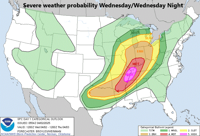
There is a “high risk” of severe weather and tornadic activity later today and tonight across the TN and MS Valley region and the area of concern extends all the north to the Upper Midwest/Ohio Valley and all the way south to Texas and Louisiana. Map courtesy NOAA/SPC
Severe weather outbreak including the high risk of strong (EF-3+) tornadoes
Numerous ingredients are coming together to produce a widespread severe weather outbreak later today and tonight and the risk is high for multiple strong (EF-3+) tornadoes. The ingredients include a broad mid-level trough of low pressure, powerful jet streaks at multiple levels of the atmosphere, and the “often seen scenario” in recent weeks of cold, dry air to the west and north clashing with warm, humid to the east and south. In addition, very strong surface low pressure will push northeastward to the Northern Plains and its associated cold front will edge eastward with widespread strong-to-severe storms along and ahead of it.
A strong jet streak in the lower part of the atmosphere will add to the instability in the atmosphere later today and tonight and the possibility of strong (EF-3+) tornadic activity. Map courtesy NOAA, tropicaltidbits.com
The area of concern for severe weather and strong tornadic activity later today and tonight extends all the way from the Mid-South (Arkansas, Louisiana, Texas) to the Upper Midwest/Ohio Valley (Indiana, Illinois, Ohio) and has a concentrated “highest risk area” of the Tennessee Valley and Lower/Middle Mississippi Valley. This “highest risk area” for severe weather and strong tornadoes includes such population centers as Memphis, TN, Pine Bluff, AR, and Jonesboro, AR and a “moderate” risk area includes Louisville, KY and Little Rock, AR.
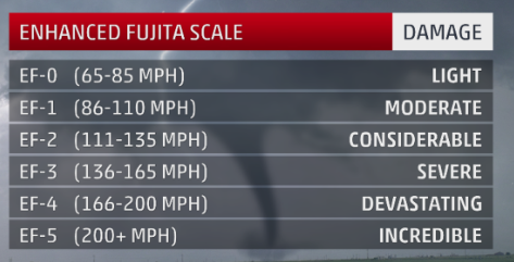
The “Enhanced Fujita” scale replaced the original back in 2007…EF-3+ tornadoes are on the table during this severe weather outbreak.
(EF-3 tornadoes on the “Enhanced Fujita” scale are associated with winds of 136-165 mph and the potential of causing severe damage. The last EF-4 tornadoes that took place occurred just a few weeks ago in the mid-March outbreak across portions of Louisiana and Mississippi. There hasn’t been an EF-5 tornado recorded since May 2013 when one formed in Moore, Oklahoma).
As much as a foot of rain can fall between today and Saturday night across the TN and MS Valley regions raising concerns for widespread and serious flooding. This part of the nation has had decent rainfall in recent weeks and the soil moisture is rather high…not a good thing going into this excessive rainfall event. Map courtesy NOAA, tropicaltidbits.com
A multi-day extreme rainfall/flooding event
Much of this same part of the nation that gets hit hard with widespread severe weather in the near-term will have to deal with a multi-day extreme rainfall event that lasts from later today through Saturday night. In fact, some parts of the Middle Mississippi Valley, Tennessee Valley, and Ohio Valley can receive more than a foot of rain between later today and Saturday night and widespread flooding is a serious concern; especially, since soil moisture is already rather high in many of these areas.
The winds aloft will be quite persistent in coming days across the Mississippi/Tennessee Valley from a southwest-to-northeast direction (as indicated by the arrow) and this will result in a stalled-out frontal boundary zone in the same area. This boundary zone will act as a conduit for moisture to flow along resulting in multiple bands of heavy rain between later today and Saturday night. The end result may be as much as a foot of rain in some sections raising concerns for widespread and serious flooding in the MS and TN Valley regions. Map courtesy NOAA, tropicaltidbits.com
The combination of humid air flowing northward from the Gulf region and a stalled out frontal boundary zone will lead to multiple rounds of heavy rain across this region right into the middle of the upcoming weekend. Winds in the upper part of the atmosphere will generally flow from southwest-to-northeast during the next few days and this will cause the cold frontal system that is edging to the east today to stall out in the same SW-to-NE fashion as the winds aloft...and right over the Middle Mississippi Valley, Tennessee Valley, and Ohio Valley. One final note, in the cold sector of this storm system, accumulating snow will fall during the next couple of days potentially on the order of 6-12 inches from the Northern Plains to the western Great Lakes.
Meteorologist Paul Dorian
Arcfield
arcfieldweather.com
Follow us on Facebook, Twitter, YouTube
Video discussion:


