**Signals for an early-to-mid November polar vortex disruption...quite a rare event for this early in the season**
Paul Dorian
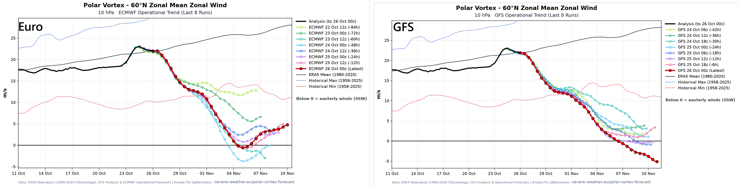
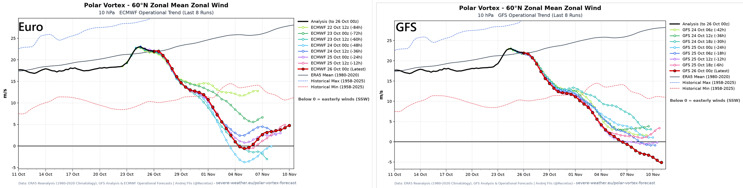
A weakening of the stratospheric winds around 60 degrees North latitude is predicted for early-to-mid November by both the Euro (left) and GFS (right). A polar vortex disruption this early in the season is quite rare and it could have “winter-like” ramifications on the weather across the US later in November and during December. Maps courtesy NOAA, ECMWF
Overview
In our “2026-2027 Winter Outlook” that was issued a couple of weeks ago, we focused on the strong El Nino episode in the tropical Pacific Ocean that looks to continue well into the upcoming winter season. In addition, we discussed in detail the generally favorable prospects for a polar vortex disruption during the upcoming winter; especially, during the second half of the season. Little did we know that there could be polar vortex disruption as soon as the early-to-middle part of November which would be quite a rare event indeed for this early in the season. Computer forecast models indicate there will be a weakening of stratospheric winds sometime during the first half of November indicating a slowing or disruption of the Arctic polar vortex which could have “winter-like” ramifications on the weather across the continental US later in the month or during December.
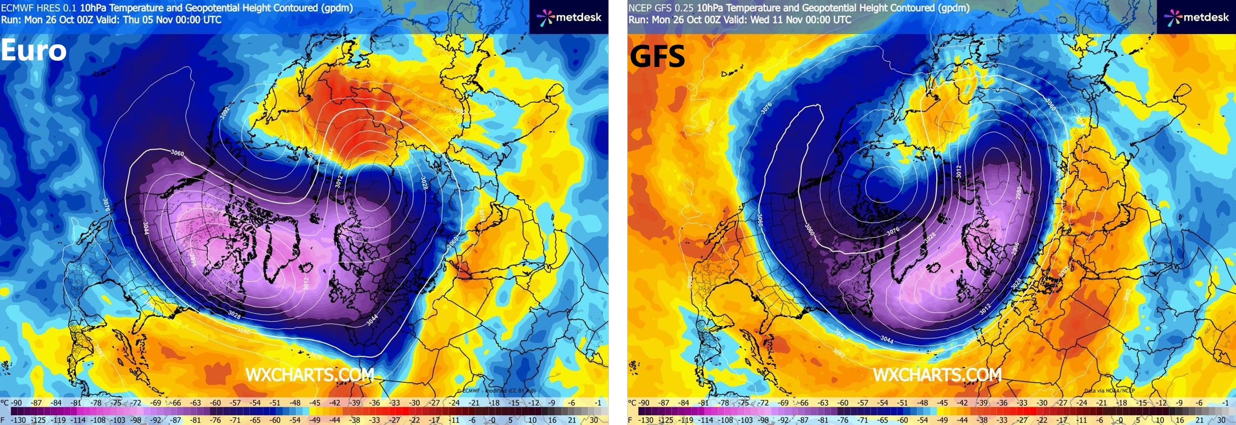
A polar vortex “stretching” is depicted here by both the Euro (left, purple) and GFS (right, purple) with warming at the stratospheric levels in areas nearby (orange). Maps courtesy NOAA, ECMWF, wxcharts.com, metdesk
Details
A stable polar vortex is typically positioned near or over the North Pole this time of year surrounded by strong westerly winds roughly around the 60°N latitude belt. If these westerly winds were to weaken – as is depicted by multiple computer forecast models – that would indicate a disruption is on the table which could manifest itself as a “displacement”, “stretching” or “splitting” of the polar vortex. If the weakening is severe enough to cause the westerly winds to completely reverse and turn easterly, it would trigger a big-time stratospheric warming event. In fact, multiple computer forecast models currently feature a “stretched” polar vortex during the first half of November with surrounding areas of warming at the stratospheric level.
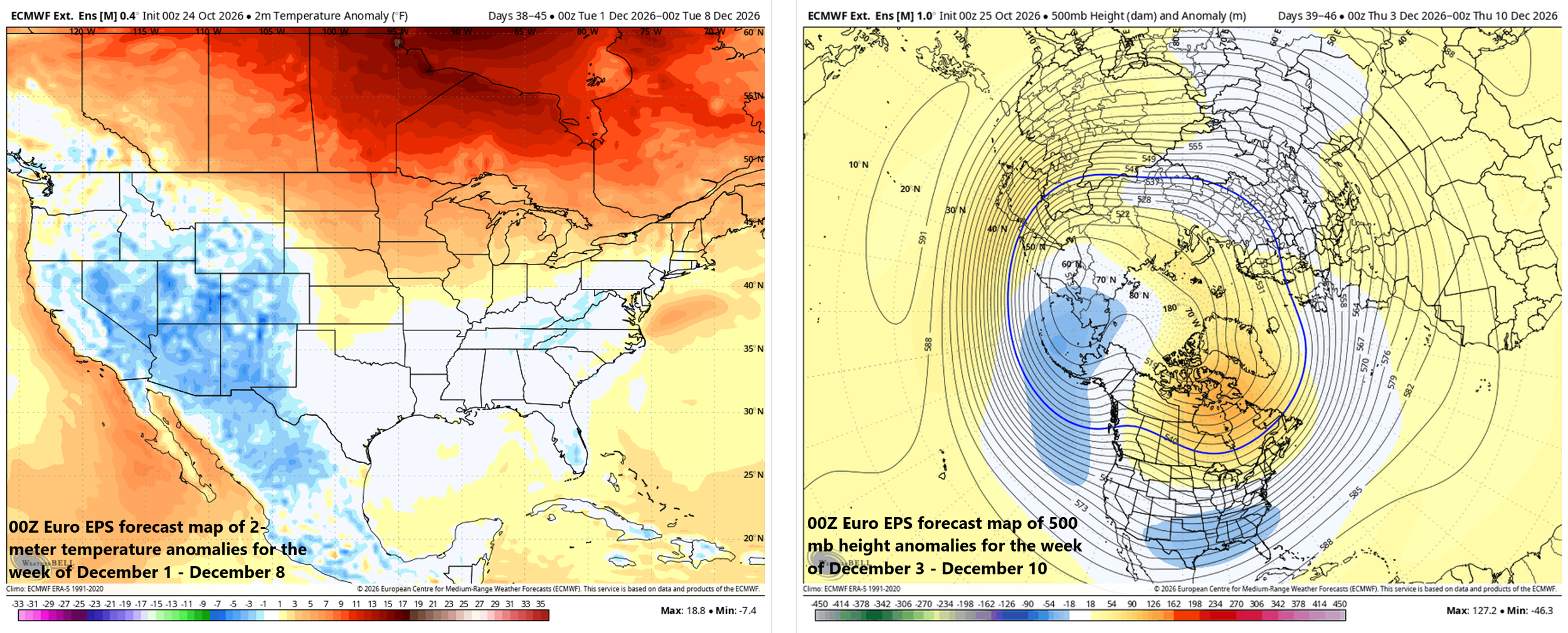
This long-range forecast from the ensemble version of the Euro features at or below normal 2-meter temperatures across the Mid-Atlantic, southern and western US (left plot) while there is a trough centered over the Deep South and high pressure ridging over Canada and Greenland (right plot)…an interesting pattern indeed for early December likely contributed to by a polar vortex disruption predicted for early-to-mid November. Maps courtesy Weather Bell Analytics, ECMWF
In terms of potential ramifications on the weather, a polar vortex disruption can promote a more wavy, meridional jet stream pattern, which can increase the chance for cold air outbreaks to move from the Arctic region to lower-latitude areas of North America, Europe or Asia. In terms of timing for possible impact, a disrupted polar vortex often couples downward to the lower atmosphere (tropopause) weeks later which could make for some interesting weather later in November and during December...especially when teamed up with an activated sub-tropical jet stream that is pumped up with lots of moisture thanks to the strong El Nino in the tropical Pacific. Long-range forecast maps from the Euro ensemble for the early part of December currently favor the idea of strong high-pressure ridging centered over Canada/Greenland and an upper-level trough centered over the Deep South while at the same time 2-meter temperatures are at or below normal across the Mid-Atlantic region, and many of the southern and western states.
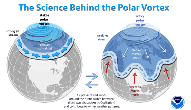
A stable polar vortex (left) this time of year would feature strong westerly winds surrounding it, but if those winds weaken or even reverse to easterly, a wavy polar vortex (right) would form potentially unleashing cold air outbreaks from the Arctic region to the middle latitudes. Graphic courtesy NOAA
Stay tuned...an early November polar vortex disruption could make for an interesting second half of the fall season.
Meteorologist Paul Dorian
Arcfield
arcfieldweather.com
Follow us on Facebook, Twitter, YouTube
Video discussion: